Spacewalk Complete And New Astronaut Record Set! Shane Kimbrough and Peggy Whitson of NASA Successfully

Spacewalk complete and new astronaut record set! Shane Kimbrough and Peggy Whitson of NASA successfully reconnected cables and electrical connections on an adapter-3 that will provide the pressurized interface between the station and the second of two international docking adapters to be delivered to the complex to support the dockings of U.S. commercial crew spacecraft in the future. The duo were also tasked with installing four thermal protection shields on the Tranquility module of the International Space Station.
Having completed her eighth spacewalk, Whitson now holds the record for the most spacewalks and accumulated time spacewalking by a female astronaut. Spacewalkers have now spent a total of 1,243 hours and 42 minutes outside the station during 199 spacewalks in support of assembly and maintenance of the orbiting laboratory.
Astronaut Thomas Pesquet of ESA posted this image and wrote, ' Shane and Peggy on their way to their first #spacewalk tasks.'
Credit: ESA/NASA
More Posts from Nasa and Others
Solar System: Things to Know This Week
There’s even more to Mars.

1. Batten Down the Hatches
Good news for future astronauts: scientists are closer to being able to predict when global dust storms will strike the Red Planet. The winds there don't carry nearly the same force that was shown in the movie "The Martian," but the dust lofted by storms can still wreak havoc on people and machines, as well as reduce available solar energy. Recent studies indicate a big storm may be brewing during the next few months.
+ Get the full forecast

2. Where No Rover Has Gone Before
Our Opportunity Mars rover will drive down an ancient gully that may have been carved by liquid water. Several spacecraft at Mars have observed such channels from a distance, but this will be the first up-close exploration. Opportunity will also, for the first time, enter the interior of Endeavour Crater, where it has worked for the last five years. All this is part of a two-year extended mission that began Oct. 1, the latest in a series of extensions going back to the end of Opportunity's prime mission in April 2004. Opportunity landed on Mars in January of that year, on a mission planned to last 90 Martian days (92.4 Earth days). More than 12 Earth years later, it's still rolling.
+ Follow along + See other recent pictures from Endeavour Crater

3. An Uphill Climb
Opportunity isn't the only NASA Mars rover getting a mission extension. On the other side of the planet, the Curiosity rover is driving and collecting samples amid some of the most scenic landscapes ever visited on Mars. Curiosity's two-year mission extension also began Oct. 1. It's driving toward uphill destinations, including a ridge capped with material rich in the iron-oxide mineral hematite, about a mile-and-a-half (two-and-a-half kilometers) ahead. Beyond that, there's an exposure of clay-rich bedrock. These are key exploration sites on lower Mount Sharp, which is a layered, Mount-Rainier-size mound where Curiosity is investigating evidence of ancient, water-rich environments that contrast with the harsh, dry conditions on the surface of Mars today.
+ Learn more

4. Keep a Sharp Lookout
Meanwhile, the Mars Reconnaissance Orbiter continues its watch on the Red Planet from above. The mission team has just released a massive new collection of super-high-resolution images of the Martian surface.
+ Take a look

5. 20/20 Vision for the 2020 Rover
In the year 2020, Opportunity and Curiosity will be joined by a new mobile laboratory on Mars. In the past week, we tested new "eyes" for that mission. The Mars 2020 rover's Lander Vision System helped guide the rocket to a precise landing at a predesignated target. The system can direct the craft toward a safe landing at its primary target site or divert touchdown toward better terrain if there are hazards in the approaching target area.
+ Get details
Discover the full list of 10 things to know about our solar system this week HERE.
Make sure to follow us on Tumblr for your regular dose of space: http://nasa.tumblr.com
What's next for NASA? In 2019, we’re once again preparing for human missions to the Moon. We're keeping the promise by developing new systems and spacecraft, making innovations in flight and technology, living and doing science on the International Space Station, and delivering images and discoveries from our home planet, our solar system and beyond.
Check out What’s Next for NASA: https://www.nasa.gov/next
Make sure to follow us on Tumblr for your regular dose of space: http://nasa.tumblr.com
Small Business Saturday: Space Edition!
Today is Small Business Saturday, an annual campaign that American Express started back in 2010 on the Saturday after Thanksgiving to support “local places that make our communities strong.”

The U.S. Senate has even taken note by passing a bipartisan resolution recognizing November 25, 2017 as Small Business Saturday: “an opportunity for all Americans to rally behind these local, independently-owned businesses and support the entrepreneurs who keep our families employed.”
Here at NASA, we look to promote and integrate small businesses across the country into the work we do to pioneer the future of space exploration, scientific discovery and aeronautics research.
Our Small Business Innovative Research (SBIR) and Small Business Technology Transfer (STTR) program seeks to fund the research, development and demonstration of innovative technologies that help address space exploration challenges and have significant potential for commercialization. In fiscal year 2017, our program awarded 567 contracts to 277 small businesses and 44 research institutions for a total of $173.5M that will enable our future missions into deep space and advancements in aviation and science, while also benefiting the U.S. economy. This year, the SBIR/STTR program’s Economic Impact Report indicated a $2.74 return for every dollar spent on awards—money well spent!

Our small business partners’ ideas have helped our work become more efficient and have advanced scientific knowledge on the International Space Station. Over 800 small businesses are contributing to the development of our Space Launch System rocket that will carry humans to deep space. SBIR/STTR program awardees are also helping the Curiosity Rover get around Mars and are even preparing the Mars 2020 Rover to search for signs of potential life on the Red Planet.

Small businesses are also contributing to scientific advances here on Earth like helping our satellites get a clearer picture of soil moisture in order to support water management, agriculture, and fire, flood and drought hazard monitoring.

In an effort to improve our understanding of the Arctic and Antarctica, a small business developed a cost-saving unmanned aircraft system that could withstand some of the coldest temperatures on the planet.

Does your small business have a big idea? Your next opportunity to join the SBIR/STTR program starts on January 11, 2018 when our latest solicitation opens.
We’ll be seeking new ideas from small businesses and research institutions for research, development and demonstration of innovative technologies. Go to www.nasa.sbir.gov to learn more.
Make sure to follow us on Tumblr for your regular dose of space: http://nasa.tumblr.com.
Five Record-Setting Gamma-ray Bursts!
For 10 years, our Fermi Gamma-ray Space Telescope has scanned the sky for gamma-ray bursts (GRBs), the universe’s most luminous explosions!

Most GRBs occur when some types of massive stars run out of fuel and collapse to create new black holes. Others happen when two neutron stars, superdense remnants of stellar explosions, merge. Both kinds of cataclysmic events create jets of particles that move near the speed of light.
A new catalog of the highest-energy blasts provides scientists with fresh insights into how they work. Below are five record-setting events from the catalog that have helped scientists learn more about GRBs:
1. Super-short burst in Boötes!

The short burst 081102B, which occurred in the constellation Boötes on Nov. 2, 2008, is the briefest LAT-detected GRB, lasting just one-tenth of a second!
2. Long-lived burst!

Long-lived burst 160623A, spotted on June 23, 2016, in the constellation Cygnus, kept shining for almost 10 hours at LAT energies — the longest burst in the catalog.
For both long and short bursts, the high-energy gamma-ray emission lasts longer than the low-energy emission and happens later.
3. Highest energy gamma-rays!

The highest-energy individual gamma ray detected by Fermi’s LAT reached 94 billion electron volts (GeV) and traveled 3.8 billion light-years from the constellation Leo. It was emitted by 130427A, which also holds the record for the most gamma rays — 17 — with energies above 10 GeV.
4. In a constellation far, far away!

The farthest known GRB occurred 12.2 billion light-years away in the constellation Carina. Called 080916C, researchers calculate the explosion contained the power of 9,000 supernovae.
5. Probing the physics of our cosmos!

The known distance to 090510 helped test Einstein’s theory that the fabric of space-time is smooth and continuous. Fermi detected both a high-energy and a low-energy gamma ray at nearly the same instant. Having traveled the same distance in the same amount of time, they showed that all light, no matter its energy, moves at the same speed through the vacuum of space.
Make sure to follow us on Tumblr for your regular dose of space: http://nasa.tumblr.com.
A Tour of our Moon
Want to go to the Moon?
Let our Lunar Reconnaissance Orbiter take you there!

Our lunar orbiter, also known as LRO, has been collecting data on lunar topography, temperature, resources, solar radiation, and geology since it launched nine years ago. Our latest collection of this data is now in 4K resolution. This updated "Tour of the Moon" takes you on a virtual tour of our nearest neighbor in space, with new science updates from the vastly expanded data trove.
Orientale Basin

First stop, Orientale Basin located on the rim of the western nearside. It's about the size of Texas and is the best-preserved impact structure on the Moon. Topography data from LRO combined with gravity measurements from our twin GRAIL spacecraft reveal the structure below the surface and help us understand the geologic consequences of large impacts.
South-Pole and Shackleton Crater

Unlike Earth, the Moon's axis is barely tilted relative to the Sun. This means that there are craters at the poles where the sunlight never reaches, called permanently shadowed regions. As a result, the Moon's South Pole has some of the coldest measured places in the solar system. How cold? -410 degrees F.
Because these craters are so cold and dark, water that happens to find its way into them never has the opportunity to evaporate. Several of the instruments on LRO have found evidence of water ice, which you can see in the highlighted spots in this visualization.
South-Pole Aitken Basin

South Pole-Aitken Basin is the Moon's largest, deepest and oldest observed impact structure. Its diameter is about 2,200 km or 1,367 miles across and takes up 1/4 of the Moon! If there was a flat, straight road and you were driving 60 mph, it would take you about 22 hours to drive across. And the basin is so deep that nearly two Mount Everests stacked on each other would fit from the bottom of the basin to the rim. South-Pole Aitken Basin is a top choice for a landing site on the far side of the Moon.
Tycho Crater

Now let's go to the near side. Tycho Crater is 100 million years young. Yes, that's young in geologic time. The central peak of the impact crater likely formed from material that rebounded back up after being compressed in the impact, almost like a spring. Check out that boulder on top. It looks small in this image, but it could fill a baseball stadium.
Aristarchus Plateau

Also prominent on the nearside is the Aristarchus Plateau. It features a crater so bright that you could see it with your naked eye from Earth! The Aristarchus Plateau is particularly interesting to our scientists because it reveals much of the Moon's volcanic history. The region is covered in rocks from volcanic eruptions and the large river-like structure is actually a channel made from a long-ago lava flow.
Apollo 17 Landing Site
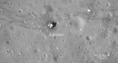
As much as we study the Moon looking for sites to visit, we also look back at places we've already been. This is because the new data that LRO is gathering helps us reinterpret the geology of familiar places, giving scientists a better understanding of the sequence of events in early lunar history.
Here, we descend to the Apollo 17 landing site in the Taurus-Littrow valley, which is deeper than the Grand Canyon. The LRO camera is even able to capture a view of the bottom half of the Apollo 17 Lunar Lander, which still sits on the surface, as well as the rover vehicle. These images help preserve our accomplishment of human exploration on the Moon's surface.
North Pole

Finally, we reach the North Pole. Like the South Pole, there are areas that are in permanent shadow and others that bask in nearly perpetual light. LRO scientists have taken detailed brightness and terrain measurements of the North Pole in order to model these areas of sunlight and shadow through time. Sunlit peaks and crater rims here may be ideal locations for generating solar power for future expeditions to the Moon.
LRO was designed as a one-year mission. Now in its ninth year, the spacecraft and the data emphasize the power of long-term data collection. Thanks to its many orbits around the Moon, we have been able to expand on lunar science from the Apollo missions while paving the way for future lunar exploration. And as the mission continues to gather data, it will provide us with many more opportunities to take a tour of our Moon.
And HERE's the full “Tour of the Moon” video:
We hope you enjoyed the tour. If you'd like to explore the moon further, please visit moon.nasa.gov and moontrek.jpl.nasa.gov.
Make sure to follow @NASAMoon on Twitter for the latest lunar updates and photos.
Make sure to follow us on Tumblr for your regular dose of space: http://nasa.tumblr.com
What is a typical day in the international space station like?? I cant help but express my admiration for you.
Summer Starts in the Northern Hemisphere!
Today is the first day of summer in the Northern Hemisphere -- the solstice! People located in the Northern Hemisphere will have the longest day of the year today, and people located in the Southern Hemisphere will have the shortest day of the year.

The angle between the Earth’s orbit and the axis of its rotation creates our seasons, tilting each hemisphere toward the Sun during summer in that half of the Earth. This is summer in the Northern Hemisphere, and winter in the Southern Hemisphere. The other half of the year, the Northern Hemisphere is tilted away from the Sun, creating winter in the north and summer in the south.

Solstices happen twice per year, at the points in Earth’s orbit where this tilt is most pronounced.

These days are the longest (in the summer hemisphere) and shortest (in the winter hemisphere) of the year, and mark the change of seasons to summer and winter, respectively.
For more Earth science, follow NASA Earth on Twitter, on Facebook, or on the web.
Make sure to follow us on Tumblr for your regular dose of space!
Seeing El Niño…From Space
First, What is El Niño?
This irregularly occurring weather phenomenon is created through an abnormality in wind and ocean circulation. When it originates in the equatorial Pacific Ocean. El Niño has wide-reaching effects. In a global context, it affects rainfall, ocean productivity, atmospheric gases and winds across continents. At a local level, it influences water supplies, fishing industries and food sources.
What About This Year’s El Niño
This winter, weather patterns may be fairly different than what is typical — all because of unusually warm ocean water in the east equatorial Pacific, aka El Niño. California is expected to get more rain while Australia is expected to get less. Since this El Niño began last summer, the Pacific Ocean has already experienced an increase in tropical storms and a decrease in phytoplankton.
How Do We See El Niño?
Here are some of El Niño’s key impacts and how we study them from space:
Rainfall:

El Niño often spurs a change in rainfall patterns that can lead to major flooding, landslides and droughts across the globe.
How We Study It: Our Global Precipitation Measurement mission (GPM), tracks precipitation worldwide and creates global precipitation maps updated every half-hour using data from a host of satellites. Scientists can then use the data to study changes in rain and snow patterns. This gives us a better understanding of Earth’s climate and weather systems.
Hurricanes:

El Niño also influences the formation of tropical storms. El Niño events are associated with fewer hurricanes in the Atlantic, but more hurricanes and typhoons in the Pacific.
How We Study It: We have a suite of instruments in space that can study various aspects of storms, such as rainfall activity, cloud heights, surface wind speed and ocean heat.
Ocean Ecology:

While El Niño affects land, it also impacts the marine food web, which can be seen in the color of the ocean. The hue of the water is influenced by the presence of tiny plants, sediments and colored dissolved organic material. During El Niño conditions, upwelling is suppressed and the deep, nutrient-rich waters aren’t able to reach the surface, causing less phytoplankton productivity. With less food, the fish population declines, severely affecting fishing industries.
How We Study It: Our satellites measure the color of the ocean to derive surface chlorophyll, a pigment in phytoplankton, and observe lower total chlorophyll amounts during El Niño events in the equatorial Pacific Ocean.
Ozone:

El Niño also influences ozone — a compound that plays an important role in the Earth system and human health. When El Niño occurs, there is a substantial change in the major east-west tropical circulation, causing a significant redistribution of atmospheric gases like ozone.
How We Study It: Our Aura satellite is used to measure ozone concentrations in the upper layer of the atmosphere. With more than a decade of Aura data, researchers are able to separate the response of ozone concentrations to an El Niño from its response to change sin human activity, such as manmade fires.
Fires:

El Niño conditions shift patters of rainfall and fire across the tropics. During El Niño years, the number and intensity of fires increases, especially under drought conditions in regions accustomed to wet weather. These fires not only damage lands, but also emit greenhouse gases that trap heat in the atmosphere and contribute to global warming.
How We Study It: Our MODIS instruments on Aqua and Terra satellites provide a global picture of fire activity. MODIS was specifically designed to observe fires, allowing scientists to discern flaming from smoldering burns.
Make sure to follow us on Tumblr for your regular dose of space: http://nasa.tumblr.com
Normal Things…Done in a Not So Normal Way
Floating around in zero gravity may sound like a blast, but it can actually present a lot of challenges to things we do everyday here on Earth with little to no thought. Here are a few ways that astronauts on the International Space Station complete normal tasks in orbit:
1) Washing Hair

You can’t just have a shower on the space station because the water would come out of the faucet and float all over the place. In this video, NASA Astronaut Karen Nyberg demonstrates how she uses a bag of water, no rinse shampoo, a towel and her comb to wash her hair.
2) Drinking Coffee

Believe it or not, there are special cups used on the space station to drink coffee from the new ISSpresso machine. I mean, you wouldn’t want hot coffee floating around in the air…would you? Previously, astronauts drank coffee from plastic bags, but let’s face it, that sounds pretty unenjoyable. Now, there are zero Gravity coffee cups, and an Italian espresso machine aboard the International Space Station! These cups were created with the help of capillary flow experiments conducted in space.
3) Sleeping

There’s nothing like crawling into bed after a long day, but astronauts can’t exactly do that while they’re in microgravity. Instead of beds, crew members use sleeping bags attached to the walls of their small crew cabins. They are able to zipper themselves in so that they don’t float around while they’re asleep. This may sound uncomfortable, but some astronauts, like Scott Kelly, say that they sleep better in space than they do on Earth!
4) Exercising

Exercising in general is an important part of a daily routine. In space, it even helps prevent the effects of bone and muscle loss associated with microgravity. Typically, astronauts exercise two hours per day, but the equipment they use is different than here on Earth. For example, if an astronaut wants to run on the treadmill, they have to wear a harness and bungee cords so that they don’t float away.
Solar System: Top 5 Things to Know This Week
1. A Ceres of Fortunate Events

Our Dawn mission continues its exploration at Ceres, and the team is working with the data coming back to Earth, looking for explanations for the tiny world’s strange features. Follow Dawn’s expedition HERE.
2. Icy Moon Rendezvous
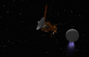
One of the most interesting places in the entire solar system is Saturn’s moon Enceladus, with its underground ocean and spectacular geyser plume. This month, the Cassini spacecraft will be buzzing close by Enceladus several times, the last such encounters of the mission. On October 14, Cassini will perform a targeted flyby at a distance of just 1,142 miles (1,838 kilometers) over the moon’s northern latitudes. Ride along with Cassini HERE.
3. Make Your Own Mars Walkabout
You can retrace Opportunity’s journey, see where the Curiosity rover is now, or even follow along with fictional astronaut Mark Watney from The Martian movie using the free online app MarsTrek. The app lets you zoom in on almost any part of the planet and see images obtained by our spacecraft, so you can plan your on Red Planet excursion. Take a hike HERE.
4. Elusive Features on Jupiter

New imagery from our Hubble Space Telescope is capturing details never before seen on Jupiter. High-resolution maps and spinning globes, rendered in the 4K Ultra HD format, reveal an elusive wave and changes to Jupiter’s Great Red Spot. Explore Jupiter HERE.
5. Mr. Blue Sky

Another week, another amazing picture from Pluto. The first color images of Pluto’s atmospheric hazes, returned by our New Horizons spacecraft last week, reveal that the hazes are blue. Who would have expected a blue sky in the Kuiper Belt? Most of the data collected during July’s Pluto flyby remains aboard the spacecraft, but the team publishes new batches of pictures and other findings on a weekly basis. Keep up with the latest HERE.
Make sure to follow us on Tumblr for your regular dose of space: http://nasa.tumblr.com
-
 rustyheart1 reblogged this · 4 years ago
 -
rustyheart1 liked this · 4 years ago
-
 lunaghostmoth liked this · 5 years ago
 -
 wiggz liked this · 5 years ago
 -
 megacosms reblogged this · 5 years ago
 -
 nervespike reblogged this · 5 years ago
 -
 a-dream-seeking-light reblogged this · 5 years ago
 -
a-dream-seeking-light liked this · 5 years ago
-
 8-bitmaster liked this · 5 years ago
 -
 mazzumblr reblogged this · 5 years ago
 -
 geamohr liked this · 5 years ago
 -
 abstractandedgyname reblogged this · 5 years ago
 -
abstractandedgyname liked this · 5 years ago
-
 o-blivia reblogged this · 5 years ago
 -
o-blivia liked this · 5 years ago
-
 eswat2 liked this · 5 years ago
 -
 curatorofthisdigitalmorass reblogged this · 5 years ago
 -
curatorofthisdigitalmorass liked this · 5 years ago
-
 jad-ee liked this · 5 years ago
 -
 0ll reblogged this · 5 years ago
 -
 6-lvck reblogged this · 5 years ago
 -
 swlfxx reblogged this · 5 years ago
 -
 c4abra-da-peste reblogged this · 5 years ago
 -
 illknight reblogged this · 6 years ago
 -
 cincoprascinco reblogged this · 6 years ago
 -
c4abra-da-peste reblogged this · 6 years ago
-
 lacrandoempalavras-blog reblogged this · 6 years ago
 -
 theandyzee liked this · 6 years ago
 -
 pretty-trukgar liked this · 6 years ago
 -
lacrandoempalavras-blog liked this · 6 years ago
Explore the universe and discover our home planet with the official NASA Tumblr account
1K posts