How Do Hurricanes Form?
How Do Hurricanes Form?
Hurricanes are the most violent storms on Earth. People call these storms by other names, such as typhoons or cyclones, depending on where they occur.

The scientific term for ALL of these storms is tropical cyclone. Only tropical cyclones that form over the Atlantic Ocean or eastern and central Pacific Ocean are called “hurricanes.”

Whatever they are called, tropical cyclones all form the same way.
Tropical cyclones are like giant engines that use warm, moist air as fuel. That is why they form only over warm ocean waters near the equator. This warm, moist air rises and condenses to form clouds and storms.

As this warmer, moister air rises, there's less air left near the Earth's surface. Essentially, as this warm air rises, this causes an area of lower air pressure below.

This starts the 'engine' of the storm. To fill in the low pressure area, air from surrounding areas with higher air pressure pushes in. That “new” air near the Earth's surface also gets heated by the warm ocean water so it also gets warmer and moister and then it rises.

As the warm air continues to rise, the surrounding air swirls in to take its place. The whole system of clouds and wind spins and grows, fed by the ocean’s heat and water evaporating from the surface.
As the storm system rotates faster and faster, an eye forms in the center. It is vey calm and clear in the eye, with very low air pressure.

Tropical cyclones usually weaken when they hit land, because they are no longer being “fed” by the energy from the warm ocean waters. However, when they move inland, they can drop many inches of rain causing flooding as well as wind damage before they die out completely.
There are five types, or categories, of hurricanes. The scale of categories is called the Saffir-Simpson Hurricane Scale and they are based on wind speed.

How Does NASA Study Hurricanes?
Our satellites gather information from space that are made into pictures. Some satellite instruments measure cloud and ocean temperatures. Others measure the height of clouds and how fast rain is falling. Still others measure the speed and direction of winds.

We also fly airplanes into and above hurricanes. The instruments aboard planes gather details about the storm. Some parts are too dangerous for people to fly into. To study these parts, we use airplanes that operate without people.
Learn more about this and other questions by exploring NASA Space Place and the NASA/NOAA SciJinks that offer explanations of science topics for school kids.
Make sure to follow us on Tumblr for your regular dose of space: http://nasa.tumblr.com.
Credits: NASA Space Place & NASA/NOAA SciJinks
More Posts from Nasa and Others
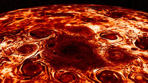
With unearthly jet-streams, many massive swirling cyclones and winds running deep into its atmosphere — new data from our Juno Mission to Jupiter unveils discoveries and clues about the gas-giant planet.
This composite image, derived from data collected by the Jovian Infrared Auroral Mapper (JIRAM) instrument aboard our Juno spacecraft, shows the central cyclone at the planet’s north pole and the eight cyclones that encircle it.
However, as tightly spaced as the cyclones are, they have remained distinct, with individual morphologies over the seven months of observations. The question is, why do they not merge? We are beginning to realize that not all gas giants are created equal.
Read more about these discoveries HERE.
Make sure to follow us on Tumblr for your regular dose of space: http://nasa.tumblr.com.
Our Planet: 8 Stunning Views of Earth from Space
Swirling clouds, deep blue oceans and textured land- and icescapes are among the many faces of our planet revealed in NASA’s new photo-essay book: Earth. This collection of 69 images captured by satellites tells a story of a 4.5-billion-year-old planet where there is always something new to see. Earth is a beautiful, awe-inspiring place, and it is the only world most of us will ever know. It is your planet. It is NASA’s mission. The book is available now in hardcover and ebook, and online with interactive features.
Here are eight of those breathtaking images for your viewing pleasure.
Channel Country, Australia

These wide floodplains in Queensland, Australia are unique on the planet. Scientists think they are caused by the extreme variation in water and sediment discharges from the rivers. In many years there is no rainfall at all, and the rivers are effectively non-existent. In years of modest rainfall, the main channels will carry some water, sometimes spilling over into narrow water holes known as billabongs.
Every few decades, the floodplain carries extremely high discharges of water. For instance, tropical storms to the north can lead to great water flows that inundate the entire width of the floodplain. On such occasions, the floodplain appears as series of brown and green water surfaces with only tree tops indicating the location of the islands. Such is the case in this image taken from the International Space Station in September 2016.
Grounded in the Caspian, Kazakhstan

A wide variety of ice forms in the Caspian Sea, which stretches from Kazakhstan to Iran. Just offshore, a well-developed expanse of consolidated ice appears bright white. Farther offshore, a gray-white field of chunky, hummocked ice has detached and is slowly drifting around a polynya, an area of open water surrounded by sea ice. That darker patch is actually growing young, thin ice and nilas, a term that designates sea ice crust up to 10 centimeters (4 inches) in thickness.
The close-up shows nilas and a white, diamond-shaped piece of ice. It might look like this chunk is on the move, cutting a path through thinner ice. But it’s more likely that the “diamond” was stuck to the sea bottom and the wind pushed ice around it.
Tsauchab River Bed, Namibia

The Tsauchab River is a famous landmark for the people of Namibia and tourists. Yet few people have ever seen the river flowing with water. In December 2009, an astronaut on the International Space Station caught this glimpse of the Tsauchab River bed jutting into the sea of red dunes. It ends in a series of light-colored, silty mud holes on the dry lake floor.
Like several other rivers around the Namib Desert, the Tsauchab brings sediment down from the hinterland toward the coastal lowland. This sediment is then blown from the river beds, and over tens of millions of years it has accumulated as the red dunes of the Namib Sand Sea.
Taranaki and Egmont, New Zealand

The circular pattern of New Zealand’s Egmont National Park stands out from space as a human fingerprint on the landscape. The park protects the forested and snow-capped slopes around Mount Taranaki (Mount Egmont to British settlers). It was established in 1900, when officials drew a radius of 10 kilometers around the volcanic peak. The colors differentiate the protected forest (dark green) from once-forested pasturelands (light- and brown-green).
Named by the native Maori people, Taranaki stands 2,518 meters (8,260 feet) tall, and it is one of the world’s most symmetric volcanoes. It first became active about 135,000 years ago. By dating lava flows, geologists have figured out that small eruptions occur roughly every 90 years and major eruptions every 500 years. Landsat 8 acquired this image of Taranaki and the park in July 2014.
Storms Stir Up Sediment in Bermuda

In October 2014, the eye of Hurricane Gonzalo passed right over Bermuda. In the process, the potent storm stirred up the sediments in the shallow bays and lagoons around the island, spreading a huge mass of sediment across the North Atlantic Ocean. This Landsat 8 image shows the area after Gonzalo passed through.
The suspended sediments were likely a combination of beach sand and carbonate sediments from around the shallows and reefs. Coral reefs can produce large amounts of calcium carbonate, which stays on the reef flats (where there are coralline algae that also produce carbonate) and builds up over time to form islands.
Framing an Iceberg in the South Atlantic Ocean

In June 2016, the Suomi NPP satellite captured this image of various cloud formations in the South Atlantic Ocean. Note how low stratus clouds framed a hole over iceberg A-56 as it drifted across the sea.
The exact reason for the hole in the clouds is somewhat of a mystery. It could have formed by chance, although imagery from the days before and after this date suggest something else was at work. It could be that the relatively unobstructed path of the clouds over the ocean surface was interrupted by thermal instability created by the iceberg. In other words, if an obstacle is big enough, it can divert the low-level atmospheric flow of air around it, a phenomenon often caused by islands.
Lofted Over Land in Madagascar

Along the muddy Mania River, midday clouds form over the forested land but not the water. In the tropical rainforests of Madagascar, there is ample moisture for cloud formation. Sunlight heats the land all day, warming that moist air and causing it to rise high into the atmosphere until it cools and condenses into water droplets. Clouds generally form where air is ascending (over land in this case), but not where it is descending (over the river). Landsat 8 acquired this image in January 2015.
A Lava Lamp Look at the Atlantic Ocean

Stretching from tropical Florida to the doorstep of Europe, the Gulf Stream carries a lot of heat, salt, and history. This river of water is an important part of the global ocean conveyor belt, moving water and heat from the Equator toward the far North Atlantic. It is one of the strongest currents on Earth and one of the most studied. Its discovery is often attributed to Benjamin Franklin, though sailors likely knew about the current long before they had a name for it.
This image shows a small portion of the Gulf Stream off of South Carolina as it appeared in infrared data collected by the Landsat 8 satellite in April 2013. Colors represent the energy—heat—being emitted by the water, with cooler temperatures in purple and the warmest water being nearly white. Note how the Gulf Stream is not a uniform band but instead has finer streams and pockets of warmer and colder water.
These images are just a few from our new book called Earth. Explore the other 61 images here.
Make sure to follow us on Tumblr for your regular dose of space: http://nasa.tumblr.com
Solar System: Things to Know This Week
Our Dawn mission to the asteroid belt is no ordinary deep space expedition.
Instead of traditional chemical rockets, the spacecraft uses sophisticated ion engines for propulsion. This enabled Dawn to become the first mission to orbit not one, but two different worlds — first the giant asteroid Vesta and now the dwarf planet Ceres. Vesta and Ceres formed early in the solar system's history, and by studying them, the mission is helping scientists go back in time to the dawn of the planets. To mark a decade since Dawn was launched on Sept. 27, 2007, here are 10 things to know about this trailblazing mission.
1. Ion Engines: Not Just for Sci-Fi Anymore

Most rocket engines use chemical reactions for propulsion, which tend to be powerful but short-lived. Dawn's futuristic, hyper-efficient ion propulsion system works by using electricity to accelerate ions (charged particles) from xenon fuel to a speed seven to 10 times that of chemical engines. Ion engines accelerate the spacecraft slowly, but they're very thrifty with fuel, using just milligrams of xenon per second (about 10 ounces over 24 hours) at maximum thrust. Without its ion engines, Dawn could not have carried enough fuel to go into orbit around two different solar system bodies. Try your hand at an interactive ion engine simulation.
2. Time Capsules

Scientists have long wanted to study Vesta and Ceres up close. Vesta is a large, complex and intriguing asteroid. Ceres is the largest object in the entire asteroid belt, and was once considered a planet in its own right after it was discovered in 1801. Vesta and Ceres have significant differences, but both are thought to have formed very early in the history of the solar system, harboring clues about how planets are constructed. Learn more about Ceres and Vesta—including why we have pieces of Vesta here on Earth.
3. Portrait of a Dwarf Planet

This view of Ceres built from Dawn photos is centered on Occator Crater, home of the famous "bright spots." The image resolution is about 460 feet (140 meters) per pixel.
Take a closer look.
4. What's in a Name?
Craters on Ceres are named for agricultural deities from all over the world, and other features carry the names of agricultural festivals. Ceres itself was named after the Roman goddess of corn and harvests (that's also where the word "cereal" comes from). The International Astronomical Union recently approved 25 new Ceres feature names tied to the theme of agricultural deities. Jumi, for example, is the Latvian god of fertility of the field. Study the full-size map.
5. Landslides or Ice Slides?

Thanks to Dawn, evidence is mounting that Ceres hides a significant amount of water ice. A recent study adds to this picture, showing how ice may have shaped the variety of landslides seen on Ceres today.
6. The Lonely Mountain

Ahuna Mons, a 3-mile-high (5-kilometer-high) mountain, puzzled Ceres explorers when they first found it. It rises all alone above the surrounding plains. Now scientists think it is likely a cryovolcano — one that erupts a liquid made of volatiles such as water, instead of rock. "This is the only known example of a cryovolcano that potentially formed from a salty mud mix, and that formed in the geologically recent past," one researcher said. Learn more.
7. Shining a Light on the Bright Spots

The brightest area on Ceres, located in the mysterious Occator Crater, has the highest concentration of carbonate minerals ever seen outside Earth, according to studies from Dawn scientists. Occator is 57 miles (92 kilometers) wide, with a central pit about 6 miles (10 kilometers) wide. The dominant mineral of this bright area is sodium carbonate, a kind of salt found on Earth in hydrothermal environments. This material appears to have come from inside Ceres, and this upwelling suggests that temperatures inside Ceres are warmer than previously believed. Even more intriguingly, the results suggest that liquid water may have existed beneath the surface of Ceres in recent geological time. The salts could be remnants of an ocean, or localized bodies of water, that reached the surface and then froze millions of years ago. See more details.
8. Captain's Log
Dawn's chief engineer and mission director, Marc Rayman, provides regular dispatches about Dawn's work in the asteroid belt. Catch the latest updates here.
9. Eyes on Dawn
Another cool way to retrace Dawn's decade-long flight is to download NASA's free Eyes on the Solar System app, which uses real data to let you go to any point in the solar system, or ride along with any spacecraft, at any point in time—all in 3-D.
10. No Stamp Required

Send a postcard from one of these three sets of images that tell the story of dwarf planet Ceres, protoplanet Vesta, and the Dawn mission overall.
Make sure to follow us on Tumblr for your regular dose of space: http://nasa.tumblr.com.
Congratulations to the Winner of the Name the Artemis Moonikin Challenge!

Congratulations to Campos! After a very close competition among eight different names, the people have decided: Commander Moonikin Campos is launching on Artemis I, our first uncrewed flight test of the Space Launch System rocket and Orion spacecraft around the Moon later this year.

The name Campos is a dedication to Arturo Campos, electrical power subsystem manager for the Apollo 13 lunar module. He is remembered as not only a key player instrumental to the Apollo 13 crew’s safe return home, but as a champion for equality in the workplace. The final bracket challenge was between Campos and Delos, a reference to the island where Apollo and Artemis were born, according to Greek mythology.

The Moonikin is a male-bodied manikin previously used in Orion vibration tests. Campos will occupy the commander’s seat inside and wear a first-generation Orion Crew Survival System — a spacesuit Artemis astronauts will wear during launch, entry, and other dynamic phases of their missions. Campos' seat will be outfitted with sensors under the headrest and behind the seat to record acceleration and vibration data throughout the mission. Data from the Moonikin’s experience will inform us how to protect astronauts during Artemis II, the first mission around the Moon with crew in more than 50 years.

The Moonikin is one of three passengers flying in place of crew aboard Orion on the mission to test the systems that will take astronauts to the Moon for the next generation of exploration. Two female-bodied model human torsos, called phantoms, will also be aboard Orion. Zohar and Helga, the phantoms named by the Israel Space Agency and the German Aerospace Center respectively, will support an investigation called the Matroshka AstroRad Radiation Experiment to provide data on radiation levels during lunar missions.

Campos, Zohar, and Helga are really excited to begin the journey around the Moon and back. The Artemis I mission will be one of the first steps to establishing a long-term presence on and around the Moon under Artemis, and will help us prepare for humanity's next giant leap — sending the first astronauts to Mars.
Be sure to follow Campos, Zohar, and Helga on their journey by following @NASAArtemis on Facebook, Twitter, and Instagram. Make sure to follow us on Tumblr for your regular dose of space!
What did the astronauts on the International Space Station see when they looked upon the Earth from orbit in 2017? See some of the top Earth observations from the year and download these pics, as chosen by our Earth Science and Remote Sensing Unit at the Johnson Space Center in Houston. Astronauts have used hand-held cameras to photograph the Earth for more than 55 years. Beginning with the Mercury missions in the early 1960s, astronauts have taken more than 1.5 million photographs of the Earth. Today, the International Space Station continues this tradition of Earth observation from human-tended spacecraft. Operational since November 2000, the space station is well suited for documenting Earth features. The orbiting laboratory maintains an altitude of about 250 miles above the Earth, providing an excellent stage for observing most populated areas of the world.
Make sure to follow us on Tumblr for your regular dose of space: http://nasa.tumblr.com.
Flying Observatory Has Big Plans for New Zealand

Our flying observatory, called SOFIA, carries a 100-inch telescope inside a Boeing 747SP aircraft. Scientists onboard study the life cycle of stars, planets (including the atmospheres of Pluto and Jupiter), nearby planetary systems, galaxies, black holes and complex molecules in space.

Flying South
Usually based in California, SOFIA and its team are returning to the Southern Hemisphere to study objects that aren't visible from the Northern Hemisphere and to take advantage of the long winter nights. The team operates from Christchurch, New Zealand, regularly between June and August and continues with more big plans for this year.

Working with New Horizons
Our SOFIA and New Horizons teams are working together again, to learn more about the next object that the New Horizons spacecraft will fly past, Kuiper Belt Object 2014 MU69, or MU69. This will be the farthest object ever encountered by any spacecraft, but little is known about it. Our team on SOFIA will be searching for possible debris around MU69 that could damage the spacecraft and will measure its size, helping the New Horizons team plan their next flyby.

How We Study Distant Celestial Objects from Earth
Our SOFIA team will study MU69 on July 10, 2017, well before New Horizons arrives in January 2019. We can study this distant object from Earth by flying in the faint shadow that it will cast on Earth’s surface as it passes in front of a star. SOFIA will fly directly into the center of this shadow as it moves across the Pacific Ocean. From inside the shadow, the team onboard will study how the light from the star changes as MU69 passes in front it, allowing them to measure its size and to establish if there are any rings or debris around it. The observations will work in the same way that we studied Pluto using SOFIA two weeks before New Horizon’s Pluto Flyby in 2015.

Observing Other Galaxies
The Magellanic Clouds are neighboring galaxies to our own Milky Way Galaxy. We’re studying how stars are forming in the Large and Small Magellanic clouds to compare those processes to star formation in our own galaxy. The Magellanic Clouds are best observed from the southern hemisphere.

And Supernova 1987A
Inside the Large Magellanic Cloud is Supernova 1987A, the closest supernova explosion witnessed in almost 400 years. Our team onboard SOFIA will continue studying this supernova to better understand the material expanding out from it, which may become the building blocks of future stars and planets. Many of our telescopes have studied Supernova 1987A, including the Hubble Space Telescope, the Chandra X-ray Observatory and SOFIA’s predecessor, the Kuiper Airborne Observatory, but the instruments on SOFIA are the only tools we can use to study the debris around it at infrared wavelengths, to better understand characteristics of the dust that cannot be measured using other wavelengths of light.
Make sure to follow us on Tumblr for your regular dose of space: http://nasa.tumblr.com
Happy International Women’s Day!

Today we celebrate International Women’s Day, a day in which we honor and recognize the contributions of women…both on Earth and in space.

Since the beginning, women have been essential to the progression and success of America’s space program.

Throughout history, women have had to overcome struggles in the workplace. The victories for gender rights were not achieved easily or quickly, and our work is not done.

Today, we strive to make sure that our legacy of inclusion and excellence lives on.

We have a long-standing cultural commitment to excellence that is largely driven by data, including data about our people. And our data shows progress is driven by questioning our assumptions and cultural prejudices – by embracing and nurturing all talent we have available, regardless of gender, race or other protected status, to build a workforce as diverse as our mission. This is how we, as a nation, will take the next giant leap in exploration.

As a world leader in science, aeronautics, space exploration and technology, we have a diverse mission that demands talent from every corner of America, and every walk of life.

So, join us today, and every day, as we continue our legacy of inclusion and excellence.

Happy International Women’s Day!
Learn more about the inspiring woman at NASA here: https://women.nasa.gov/
What dose it feel like being inside a space suit?
The suit weighs about 300 pounds. We are made neutrally buoyant in the pool, but over time we can become negatively buoyant. The suit can feel heavy, even the bearings can become stiff, so it can be difficult to operate in the suit. With practice and the help of a great spacewalk team, we can make a spacewalk look seamless.
Solar System: Things to Know This Week
Mark your calendars for summer 2018: That's when we're launching a spacecraft to touch the sun.
In honor of our first-ever mission to the heart of the solar system, this week we’re delving into the life and times of this powerful yellow dwarf star.

1. Meet Parker
Parker Solar Probe, our first mission to go to the sun, is named after Eugene Parker, an American astrophysicist who first theorized that the sun constantly sends out a flow of particles and energy called the solar wind. This historic mission will explore one of the last regions of the solar system to be visited by a spacecraft and help scientists unlock answers to questions they've been pondering for more than five decades.

2. Extra SPF, Please
Parker Solar Probe will swoop within 4 million miles of the sun's surface, facing heat and radiation like no spacecraft before it. The mission will provide new data on solar activity to help us better understand our home star and its activity - information that can improve forecasts of major space-weather events that could impact life on Earth.

3. Majorly Massive
The sun is the center of our solar system and makes up 99.8 percent of the mass of the entire solar system. If the sun were as tall as a typical front door, Earth would be about the size of a nickel.
4. Different Spin
Since the sun is not a solid body, different parts of the sun rotate at different rates. At the equator, the sun spins once about every 25 days, but at its poles the sun rotates once on its axis every 36 Earth days.

5. Can't Stand on It
The sun is a star and a star doesn't have a solid surface. Rather, it's a ball of ionized gas 92.1% hydrogen (H2) and 7.8% helium (He) held together by its own gravity.
6. Center of Attention
The sun isn't a planet, so it doesn't have any moons. But, the sun is orbited by eight planets, at least five dwarf planets, tens of thousands of asteroids, and hundreds of thousands to trillions of comets and icy bodies.

7. It's Hot in There
And we mean really, really hot. The temperature at the sun's core is about 27 million degrees Fahrenheit. However, its atmosphere, the corona, can reach temperatures of 3 million degrees. (That's as if it got hotter the farther away you got from a fire, instead of cooler!) Parker Solar Probe will help scientists solve the mystery of why the corona's temperature is so much higher than the surface.

8. Travel Conditions
The sun influences the entire solar system, so studying it helps us better understand the space weather that our astronauts and spacecraft travel through.
9. Life on the Sun?
Better to admire from afar. Thanks to its hot, energetic mix of gases and plasma, the sun can't be home to living things. However, we can thank the sun for making life on Earth possible by providing the warmth and energy that supply Earth’s food chain.
10. Chance of a Lifetime
Last but not least, don't forget that the first total solar eclipse to sweep across the U.S. from coast-to-coast since 1918 is happening on August 21, 2017. Our toolkit has you need to know to about it.
Want to learn more? Read our full list of the 10 things to know this week about the solar system HERE.
Make sure to follow us on Tumblr for your regular dose of space: http://nasa.tumblr.com
How Climate Change Showed Up in 2021
2021 was tied for the sixth-hottest year since modern record keeping began. We work together with the National Oceanic and Atmospheric Administration to track temperatures around the world and study how they change from year to year.

For decades, the overall global temperature has been increasing because of human activities. The last decade has been the warmest on record. Each individual year’s average temperature, however, can be affected by things like ocean circulation, volcanic eruptions, and specific weather events.
For instance, last year we saw the beginning of La Niña – a pattern of cooler waters in the Pacific – that was responsible for slightly cooling 2021’s average temperature. Still, last year continued a long-term trend of global warming.
Globally, Earth’s temperature in 2021 was nearly 2°F warmer than the late 19th Century, for the seventh year in a row.

The Record
Studying 142 Years
Since 1880, we can put together a consistent record of temperatures around the planet and see that it was much colder in the late-19th century. Before 1880, uncertainties in tracking global temperatures are larger. Temperatures have increased even faster since the 1970s, the result of increasing greenhouse gases in the atmosphere.
Tracking Millions of Individual Observations
Our scientists use millions of individual observations of data from more than 20,000 weather stations and Antarctic research stations, together with ship- and buoy-based observations of sea surface temperatures, to track global temperatures.

Reviewing Multiple Independent Records
Our global temperature record – GISTEMP – is one of a number of independent global temperature records, all of which show the same pattern of warming.

The Consequences
Everywhere Experiences Climate Change Differently
As Earth warms, temperature changes occur unevenly around the globe. The Arctic is currently warming about four times faster than the rest of the planet – a process called Arctic amplification. Similarly, urban areas tend to warm faster than rural areas, partly because building materials like asphalt, steel and concrete retain heat.

Droughts and Floods in Warmer Weather
More than 88% of the Western US experienced drought conditions in 2021. At the same time, communities in Western Europe saw two months’ worth of rain in 24 hours, breaking records and triggering flash floods. Because a hotter climate means more water can be carried in the atmosphere, areas like the Western US suffer drought from the increased 'thirstiness' of the atmosphere, while precipitation events can become more extreme as the amount of moisture in the atmosphere rises.

Sea Levels Continue to Rise
Melting ice raises sea levels around the world, as meltwater drains into the ocean. In addition, heat causes the ocean water to expand. From 1993 to today, global mean sea level has been rising around 3.4 millimeters per year. In 2021, sea level data from the recently launched NASA/ESA Sentinel-6 Michael Freilich mission became available to the public.

There is Hope
“This is not good news, but the fact that we are able to track this in real time and understand why it’s changing, and get people to notice why it’s changing and how we can change things to change the next trajectory, that gives me hope. Because we’re not in the dark here. We’re not the dinosaurs who are unaware the comet is coming. We can see the comet coming, and we can act.” – Dr. Gavin Schmidt, director of NASA GISS, where the global temperature record is calculated
Make sure to follow us on Tumblr for your regular dose of space!
-
 sirtakus liked this · 4 months ago
 -
 zero-phuks-given reblogged this · 10 months ago
 -
 fysanayairani liked this · 1 year ago
 -
 nycinfernoparty liked this · 2 years ago
 -
 wolf-fxxx liked this · 4 years ago
Explore the universe and discover our home planet with the official NASA Tumblr account
1K posts