The Return Of The Dragon 🐉
The return of the Dragon 🐉
One month ago, SpaceX’s Dragon capsule arrived at the International Space Station. Now it’s time for the Dragon to come home. The return trip, a crucial part of its mission, brings scientific hardware, data and experiments down to waiting researchers.
Check out a few of the pieces of research taking that ride back to Earth.

A cinematic look at life and science aboard the space station
You may one day get to experience the product of The ISS Experience. A team is creating a cinematic virtual reality (VR) film from footage taken during in space covering crew life, execution of science and the international partnerships involved on the space station.

Every week or so, footage is transferred from the camera onto solid state drives – an original and a backup – for storage and downlinking. One of each pair of drives returns to Earth for editing and production.
Seeking Alzheimer’s understanding in microgravity
Amyloid fibrils, a conglomeration of proteins that can build up in the body, are associated with a number of neurodegenerative diseases such as Alzheimer’s and Parkinson’s diseases. The Amyloid Aggregation investigation assesses whether microgravity affects formation of these fibrils.

Samples exposed to microgravity are coming back to Earth using a facility that maintains a chilly temperature of -20°C. Teams on the ground must quickly retrieve the equipment and keep the samples at -20°C until they are analyzed.
The SPHERES return home
Synchronized Position Hold, Engage, Reorient, Experimental Satellites, or SPHERES, are bowling-ball sized satellites used to study formation flying, control algorithms and material science.

First sent to the station in 2006, these satellites have been employed in a dozen different investigations.

The Dragon brings back hardware from two recent experiments that examined the behavior of fluids in microgravity, SPHERES Tether Slosh and SPHERES-Slosh.
From microgravity lab to manufacturing facility
The Fiber Optic Production investigation created optical fibers on the space station using a blend of materials called ZBLAN to see whether making the fibers in microgravity has advantages over the process used on Earth. ZBLAN optical fibers offer high bandwidth for the telecommunications industry, and potential applications for uses like laser surgery and environmental monitoring.

The fiber produced on the space station is coming to Earth for testing to help verify previous studies and guide future efforts to manufacture large volumes of such fiber in microgravity.
Read more about the science returning on Dragon here!
For daily updates, follow @ISS_Research, Space Station Research and Technology News or our Facebook. Follow the ISS National Lab for information on its sponsored investigations. For opportunities to see the space station pass over your town, check out Spot the Station.
Make sure to follow us on Tumblr for your regular dose of space: http://nasa.tumblr.com.
More Posts from Nasa and Others
10 Ways to Observe the Moon for International Observe the Moon Night
On Saturday, October 5, we will host the 10th annual International Observe the Moon Night. One day each year, everyone on Earth is invited to observe and learn about the Moon together, and to celebrate the cultural and personal connections we all have with our nearest celestial neighbor! This year is particularly special as we mark the 50th anniversary of the Apollo 11 Moon landing while looking forward to our Artemis program, which will send the first woman and next man to the Moon.
There are many ways to participate in International Observe the Moon Night. You can attend an event, host your own or just look up! Here are 10 of our favorite ways to observe the Moon.
1. Look up

Image Credit: NASA’s Scientific Visualization Studio/Ernie Wright
The simplest way to observe the Moon is simply to look up. The Moon is the brightest object in our night sky, the second brightest in our daytime sky and can be seen from all around the world — from the remote and dark Atacama Desert in Chile to the brightly lit streets of Tokyo. On October 5, we have a first quarter Moon, which means that the near side of the Moon will be 50 percent illuminated. The first quarter Moon is a great phase for evening observing. Furthermore, the best lunar observing is typically along the Moon's terminator (the line between night and day) where shadows are the longest, rather than at full Moon. See the Moon phase on October 5 or any other day of the year!
2. Peer through a telescope or binoculars

Image Credit: NASA/Molly Wasser
With some magnification help, you will be able to focus in on specific features on the Moon. In honor of this year’s 50th Anniversary of the Apollo 11 Moon Landing, see if you can find Mare Tranquillitatis (Sea of Tranquility)! Download our Moon maps for some guided observing on Saturday.
3. Photograph the Moon

Image Credit: NASA/GSFC/Arizona State University
Our Lunar Reconnaissance Orbiter (LRO) has taken more than 20 million images of the Moon, mapping it in stunning detail. You can see featured, captioned images on LRO’s camera website, like the crater seen above. And, of course, you can take your own photos from Earth. Check out our tips on photographing the Moon!
4. Relax on your couch

Image Credit: NASA’s Scientific Visualization Studio/Ernie Wright
Is it cloudy? Luckily, you can observe the Moon from the comfort of your own home. The Virtual Telescope Project will livestream the Moon from above the Roman skyline. Or, you can take and process your own lunar images with the MicroObservatory Robotic Telescopes. Would you prefer a movie night? There are many films that feature our nearest neighbor. Also, you can spend your evening with our lunar playlist on YouTube or this video gallery, learning about the Moon’s role in eclipses, looking at the Moon phases from the far side and seeing the latest science portrayed in super high resolution.
5. Touch the topography

Image Credit: NASA GSFC/Jacob Richardson
Observe the Moon with your hands! If you have access to a 3D printer, you can peruse our library of 3D models and lunar landscapes. This collection of Apollo resources features 3D models of the Apollo landing sites using topographic data from LRO and the SELENE mission. The 3D printed model you see above is of the Ina D volcanic landform.
6. Make and admire Moon art

Image Credit: LPI/Andy Shaner
Enjoy artwork of the Moon and create your own! For messy fun, lunar crater paintings demonstrate how the lunar surface changes due to frequent meteorite impacts.
7. Listen to the Moon
Image Credit: NASA Explorers: Apollo/System Sounds
Treat your ears this International Observe the Moon Night. Our audio series, NASA Explorers: Apollo features personal stories from the Apollo era to now, including yours! You can participate by recording and sharing your own experiences of Apollo with us. Learn some lunar science with the second season of our Gravity Assist podcast with NASA Chief Scientist, Jim Green. Make a playlist of Moon-themed songs. For inspiration, check out this list of lunar tunes. We also recommend LRO’s official music video, The Moon and More, featuring Javier Colon, season 1 winner of NBC’s “The Voice.” Or you can watch this video featuring “Clair de Lune,” by French composer Claude Debussy, over and over.
8. Take a virtual field trip

Image Credit: NASA/SSERVI
Plan a lunar hike with Moon Trek. Moon Trek is an interactive Moon map made using NASA data from our lunar spacecraft. Fly anywhere you’d like on the Moon, calculate the distance or the elevation of a mountain to plan your lunar hike, or layer attributes of the lunar surface and temperature. If you have a virtual reality headset, you can experience Moon Trek in 3D.
9. See the Moon through the eyes of a spacecraft

Image Credit: NASA/GSFC/MIT
Visible light is just one tool that we use to explore our universe. Our spacecraft contain many different types of instruments to analyze the Moon’s composition and environment. Review the Moon’s gravity field with data from the GRAIL spacecraft or decipher the maze of this slope map from the laser altimeter onboard LRO. This collection from LRO features images of the Moon’s temperature and topography. You can learn more about the different NASA missions to explore the Moon here.
10. Continue your observations throughout the year

Image Credit: NASA’s Scientific Visualization Studio/Ernie Wright
An important part of observing the Moon is to see how it changes over time. International Observe the Moon Night is the perfect time to start a Moon journal. See how the shape of the Moon changes over the course of a month, and keep track of where and what time it rises and sets. Observe the Moon all year long with these tools and techniques!
However you choose to celebrate International Observe the Moon Night, we want to hear about it! Register your participation and share your experiences on social media with #ObserveTheMoon or on our Facebook page. Happy observing!
Make sure to follow us on Tumblr for your regular dose of space: http://nasa.tumblr.com.
Our Spacecraft Have Discovered a New Magnetic Process in Space
Just as gravity is one key to how things move on Earth, a process called magnetic reconnection is key to how electrically-charged particles speed through space. Now, our Magnetospheric Multiscale mission, or MMS, has discovered magnetic reconnection – a process by which magnetic field lines explosively reconfigure – occurring in a new and surprising way near Earth.

Invisible to the eye, a vast network of magnetic energy and particles surround our planet — a dynamic system that influences our satellites and technology. The more we understand the way those particles move, the more we can protect our spacecraft and astronauts both near Earth and as we explore deeper into the solar system.

Earth’s magnetic field creates a protective bubble that shields us from highly energetic particles that stream in both from the Sun and interstellar space. As this solar wind bathes our planet, Earth’s magnetic field lines get stretched. Like elastic bands, they eventually release energy by snapping and flinging particles in their path to supersonic speeds.

That burst of energy is generated by magnetic reconnection. It’s pervasive throughout the universe — it happens on the Sun, in the space near Earth and even near black holes.

Scientists have observed this phenomenon many times in Earth’s vast magnetic environment, the magnetosphere. Now, a new study of data from our MMS mission caught the process occurring in a new and unexpected region of near-Earth space. For the first time, magnetic reconnection was seen in the magnetosheath — the boundary between our magnetosphere and the solar wind that flows throughout the solar system and one of the most turbulent regions in near-Earth space.

The four identical MMS spacecraft — flying through this region in a tight pyramid formation — saw the event in 3D. The arrows in the data visualization below show the hundreds of observations MMS took to measure the changes in particle motion and the magnetic field.

The data show that this event is unlike the magnetic reconnection we’ve observed before. If we think of these magnetic field lines as elastic bands, the ones in this region are much smaller and stretchier than elsewhere in near-Earth space — meaning that this process accelerates particles 40 times faster than typical magnetic reconnection near Earth. In short, MMS spotted a completely new magnetic process that is much faster than what we’ve seen before.

What’s more, this observation holds clues to what’s happening at smaller spatial scales, where turbulence takes over the process of mixing and accelerating particles. Turbulence in space moves in random ways and creates vortices, much like when you mix milk into coffee. The process by which turbulence energizes particles in space is still a big area of research, and linking this new discovery to turbulence research may give insights into how magnetic energy powers particle jets in space.
Keep up with the latest discoveries from the MMS mission: @NASASun on Twitter and Facebook.com/NASASunScience.
Make sure to follow us on Tumblr for your regular dose of space: http://nasa.tumblr.com.
6 Ways NASA is Involved in Climate Science
When it comes to climate change, we play a unique role in observing and understanding changes to the planet. Thanks to NASA’s Earth observations and related research, we know our planet and its climate are changing profoundly. We also know human activities, like releasing carbon dioxide and methane into the atmosphere, are driving this change.
Not only do we make these observations, we help people and groups use this knowledge to benefit society. The work we do at NASA is critical to helping us understand the ways our planet is responding to increased temperatures.

Here are 6 ways that we are involved in climate science and informing decisions:
1. Monitoring Earth’s vital signs
Just like a doctor checks your vitals when you go in for a visit, here at NASA we are constantly monitoring Earth’s vital signs - carbon dioxide levels, global temperature, Arctic sea ice minimum, the ice sheets and sea level, and more.

We use satellites in space, observations from airplanes and ships, and data collected on the ground to understand our planet and its changing climate. Scientists also use computers to model and understand what's happening now and what might happen in the future.

People who study Earth see that the planet’s climate is getting warmer. Earth's temperature has gone up more than 1 degree Celsius (~2 degrees Fahrenheit) in the last 100 years. This may not seem like much, but small changes in Earth's temperature can have big effects. The current warming trend is of particular significance, because it is predominantly the result of human activity since the mid-20th century and is proceeding at an unprecedented rate.

People drive cars. People heat and cool their houses. People cook food. All those things take energy. Human-produced greenhouse gas emissions are largely responsible for warming our planet. Burning fossil fuels -- which includes coal, oil, and natural gas -- releases greenhouse gases such as carbon dioxide into the atmosphere, where they act like an insulating blanket and trap heat near Earth’s surface.
At NASA, we use satellites and instruments on board the International Space Station to confirm measurements of atmospheric carbon levels. They’ve been increasing much faster than any other time in history.

2. Tracking global land use and its impacts
We also monitor and track global land use. Currently, half the world's population lives in urban areas, and by 2025, the United Nations projects that number will rise to 60%.

With so many people living and moving to metropolitan areas, the scientific world recognizes the need to study and understand the impacts of urban growth both locally and globally.

The International Space Station helps with this effort to monitor Earth. Its position in low-Earth orbit provides variable views and lighting over more than 90% of the inhabited surface of Earth, a useful complement to sensor systems on satellites in higher-altitude polar orbits. This high-resolution imaging of land and sea allows tracking of urban and forest growth, monitoring of hurricanes and volcanic eruptions, documenting of melting glaciers and deforestation, understanding how agriculture may be impacted by water stress, and measuring carbon dioxide in Earth’s atmosphere.
3. Research into the causes of climate change
Being able to monitor Earth’s climate from space also allows us to understand what’s driving these changes.

With the CERES instruments, which fly on multiple Earth satellites, our scientists measure the Earth’s planetary energy balance – the amount of energy Earth receives from the Sun and how much it radiates back to space. Over time, less energy being radiated back to space is evidence of an increase in Earth’s greenhouse effect. Human emissions of greenhouse gases are trapping more and more heat.

NASA scientists also use computer models to simulate changes in Earth’s climate as a result of human and natural drivers of temperature change.

These simulations show that human activities such as greenhouse gas emissions, along with natural factors, are necessary to simulate the changes in Earth’s climate that we have observed; natural forces alone can’t do so.
4. Research into the effects of climate change
Global climate change has already had observable effects on the environment. Glaciers and ice sheets have shrunk, ice on rivers and lakes is breaking up earlier, plant and animal ranges have shifted, and trees are flowering sooner.

The effects of global climate change that scientists predicted are now occurring: loss of sea ice, accelerated sea level rise and longer, more intense heat waves.
Climate modelers have predicted that, as the planet warms, Earth will experience more severe heat waves and droughts, larger and more extreme wildfires, and longer and more intense hurricane seasons on average. The events of 2020 are consistent with what models have predicted: extreme climate events are more likely because of greenhouse gas emissions.

Plants are also struggling to keep up with rising carbon dioxide levels. Plants play a key role in mitigating climate change. The more carbon dioxide they absorb during photosynthesis, the less carbon dioxide remains trapped in the atmosphere where it can cause temperatures to rise. But scientists have identified an unsettling trend – 86% of land ecosystems globally are becoming progressively less efficient at absorbing the increasing levels of carbon dioxide from the atmosphere.
Helping organizations to use all the data and knowledge NASA generates is another part of our job. We’ve helped South Dakota fight West Nile Virus, helped managers across the Western U.S. handle water, helped The Nature Conservancy protect land for shorebirds, and others. We also support developing countries as they work to address climate and other challenges through a 15-year partnership with the United States Agency for International Development.
5. Action on sustainability
Sustainability involves taking action now to enable a future where the environment and living conditions are protected and enhanced. We work with many government, nonprofit, and business partners to use our data and modeling to inform their decisions and actions. We are also working to advance technologies for more efficient flight, including hybrid-electric propulsion, advanced materials, artificial intelligence, and machine learning.

These advances in research and technology will not only bring about positive changes to the climate and the world in which we live, but they will also drive the economic engine of America and our partners in industry, to remain the world-wide leader in flight development.
We partner with the private sector to facilitate the transfer of our research and NASA-developed technologies. Many innovations originally developed for use in the skies above help make life more sustainable on Earth. For example:
Our Earth-observing satellites help farmers produce more with less water.
Expertise in rocket engineering led to a technique that lessens the environmental impact of burning coal.
A fuel cell that runs equipment at oil wells reduces the need to vent greenhouse gases.
6. Applying climate research to preserve NASA centers in coastal areas
Sea level rise in the two-thirds of Earth covered by water may jeopardize up to two-thirds of NASA's infrastructure built within mere feet of sea level.

Some NASA centers and facilities are located in coastal real estate because the shoreline is a safer, less inhabited surrounding for launching rockets. But now these launch pads, laboratories, airfields, and testing facilities are potentially at risk because of sea level rise. We’ve worked internally at NASA to identify climate risks and support planning at our centers.
NASA Climate Science
Climate change is one of the most complex issues facing us today. It involves many dimensions – science, economics, society, politics, and moral and ethical questions – and is a global problem, felt on local scales, that will be around for decades and centuries to come. With our Eyes on the Earth and wealth of knowledge on the Earth’s climate system and its components, we are one of the world’s experts in climate science.
Visit our Climate site to explore and learn more.
Make sure to follow us on Tumblr for your regular dose of space: http://nasa.tumblr.com
Go Behind-the-Scenes at NASA
Are you active on social media? Want to go behind-the-scenes at NASA and meet our scientists, engineers, astronauts and managers? Want to see and feel a rocket launch in-person? Then you would love our NASA Social events!

A NASA Social is a program that provides opportunities for our social media followers (like you!) to learn and share information about our missions, people and programs. Formerly known as NASA Tweetups, these socials include both special in-person events and social media credentials for people who share the news in a significant way. To date, this program has brought thousands of people together for unique social media experiences of exploration and discovery.

NASA Socials range from two hours to two days in length and include a “meet and greet” session to allow participants to mingle with fellow socialites and the people behind our social media accounts. The participants are selected from those who register their interest for the event on the web.

Do you need to have a social media account to register for a NASA Social?
Yes. The socials are designed for social media users who follow @NASA on a variety of platforms. The goal of NASA Socials is to allow people who regularly interact with each other via these platforms to meet in person and discuss one of their favorite subjects: NASA!
What types of events have we hosted in the past? Take a look:

Participants for a NASA Social surrounding the launch of a SpaceX cargo vehicle to the International Space Station met with former Deputy Administrator Lori Garver underneath the engines of the Saturn V rocket.

A participant at a NASA Social in Washington tweets as he listens to astronaut Joe Acaba answer questions about his time living aboard the International Space Station.

Juno launch Tweetup participants pose for a group photo with NASA Administrator Charles Bolden with the Vehicle Assembly Building (VAB) in the background at Kennedy Space Center.

And of course, some of our NASA Socials culminate with a rocket launch! You can experience one in-person. Apply to attend a once in a lifetime experience.
For more information about NASA Social events, and to see upcoming opportunities, visit: http://www.nasa.gov/social
Make sure to follow us on Tumblr for your regular dose of space: http://nasa.tumblr.com
The Martian Movie and Our Real Journey to Mars
The Martian movie is set 20 years in the future, but here at NASA we are already developing many of the technologies that appear in the film. The movie takes the work we’re doing and extends it into fiction set in the 2030s, when NASA astronauts are regularly traveling to Mars and living on the surface. Here are a few ways The Martian movie compares to what we’re really doing on our journey to Mars:
Analog Missions

MOVIE: In the film, Astronaut Mark Watney is stranded on the Red Planet.
REALITY: In preparation for sending humans to Mars, we have completed one of the most extensive isolation missions in Hawaii, known as HI-SEAS. The goal of this study was to see how isolation and the lack of privacy in a small group affects social aspects of would-be explorers. The most recent simulation was eight months long, and the next mission is planned to last a year.
Spaceport

MOVIE: The Martian movie launches astronauts on the Aries missions from a refurbished and state of the art space center.
REALITY: Currently, the Ground Systems Development and Operations’ primary objective is to prepare the center to process and launch the next-generation vehicles and spacecraft designed to achieve our goals for space exploration. We are not only working to develop new systems, but also refurbishing and upgrading infrastructure to meet future demands.
Deep Space Propulsion

MOVIE: In the film, the astronauts depart the Red Planet using a propulsion system know as the Mars Ascent Vehicle (MAV).
REALITY: We are currently developing the most powerful rocket we’ve ever built, our Space Launch System (SLS). Once complete, this system will enable astronauts to travel deeper into the solar system than ever before! The RS-25 engines that will be used on the SLS, were previously utilized as the main engine on our space shuttles. These engines have proven their reliability and are currently being refurbished with updated and improved technology for our journey to Mars.
Mission Control

MOVIE: In the movie, Mission Control operations support the Aries 3 crew.
REALITY: On our real journey to Mars, Mission Control in Houston will support our Orion spacecraft and the crew onboard as they travel into deep space.
Habitat

MOVIE: The artificial living habitat on Mars in The Martian movie is constructed of industrial canvas and contains an array of life support systems.
REALITY: The Human Exploration Research Analog (HERA), formerly known as the Deep Space Habitat, is a three-story module that was designed and created through a series of university competitions. Studies conducted in habitat mockups will allow us to evolve this technology to create a reliable structures for use on Mars.
Rover

MOVIE: The characters in the film are able to cruise around the Red Planet inside the Mars Decent Vehicle (MDV).
REALITY: We are currently developing a next generation vehicle for space exploration. Our Mars Exploration Vehicle (MEV) is designed to be flexible depending on the destination. It will have a pressurized cabin, ability to house two astronauts for up to 14 days and will be about the size of a pickup truck.
Harvest

MOVIE: Astronaut Mark Watney grows potatoes on Mars in The Martian movie.
REALITY: We’re already growing and harvesting lettuce on the International Space Station in preparation for deep space exploration. Growing fresh food in space will provide future pioneers with a sustainable food supplement, and could also be used for recreational gardening during deep space missions.
Spacesuit

MOVIE: The spacesuit worn by astronauts in the film allows them to work and function on the surface of Mars, while protecting them from the harsh environment.
REALITY: Prototypes of our Z-2 Exploration Suit are helping to develop the technologies astronauts will use to live and work on the the Martian surface. Technology advances in this next generation spacesuit would shorten preparation time, improve safety and boost astronaut capabilities during spacewalks and surface activities.
Pumpkin space latte, anyone? ☕
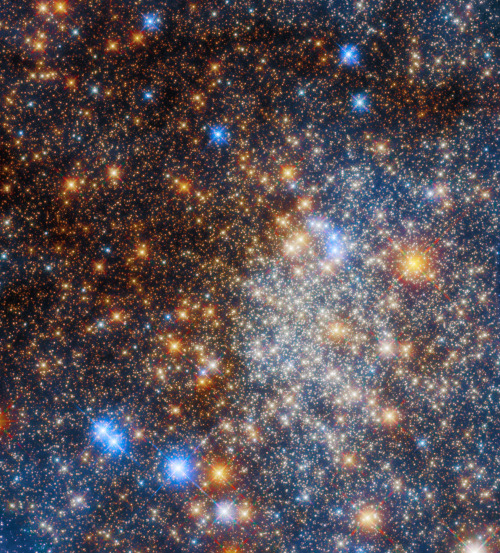
Hubble captured this festive array of stars, Terzan 12, found in the Milky Way about 15,000 light-years from Earth. The stars in this cluster are bound together by gravity in a sphere-like shape and are shrouded in gas and dust. As the starlight travels through that gas and dust to Earth, blue light scatters, leaving the redder wavelengths to come through.
Download the full-resolution image here.
Make sure to follow us on Tumblr for your regular dose of space!
Let It Snow for Science
When the weather outside is frightful…
Science in the field gets even more delightful. Two different missions are in the field right now, studying snow and how it affects communities around the country.
From our Wallops Flight Facility in Virginia, the IMPACTS mission is flying up and down the East Coast, investigating how snow forms inside clouds. In Grand Mesa, Colorado, SnowEx’s teams on the ground and in the air are taking a close look at how much water is stored in snow.

Hate going out in the storm? The IMPACTS mission can help with that! IMPACTS uses two planes – a P-3 Orion and an ER-2 – flying through and high above the clouds to study where intense bands of snowfall form. Better understanding where intense snow will fall can improve forecast models down the road — helping prepare communities for snowstorms.

Cameras mounted on the wings of the P3 took microscopic images of snowflakes, like this one.

At the same time, the SnowEx team is in Colorado, studying the depth and density of snow. Researchers are making radar spirals with snowmobiles and working in giant snow pits to measure things like snow water equivalent, or how much water is stored in snow.

SnowEx is helping us better understand snow’s role in ecosystems and human systems, like irrigation for agriculture. If you want to bring some corn for popping, SnowEx’s science can help grow that crop.

Follow along with our teams as they brave the cold and snow: https://twitter.com/nasaexpeditions
Make sure to follow us on Tumblr for your regular dose of space: http://nasa.tumblr.com
Eclipse Across America
August 21, 2017, the United States experienced a solar eclipse!

An eclipse occurs when the Moon temporarily blocks the light from the Sun. Within the narrow, 60- to 70-mile-wide band stretching from Oregon to South Carolina called the path of totality, the Moon completely blocked out the Sun’s face; elsewhere in North America, the Moon covered only a part of the star, leaving a crescent-shaped Sun visible in the sky.

During this exciting event, we were collecting your images and reactions online.
Here are a few images of this celestial event...take a look:

This composite image, made from 4 frames, shows the International Space Station, with a crew of six onboard, as it transits the Sun at roughly five miles per second during a partial solar eclipse from, Northern Cascades National Park in Washington. Onboard as part of Expedition 52 are: NASA astronauts Peggy Whitson, Jack Fischer, and Randy Bresnik; Russian cosmonauts Fyodor Yurchikhin and Sergey Ryazanskiy; and ESA (European Space Agency) astronaut Paolo Nespoli.
Credit: NASA/Bill Ingalls

The Bailey's Beads effect is seen as the moon makes its final move over the sun during the total solar eclipse on Monday, August 21, 2017 above Madras, Oregon.
Credit: NASA/Aubrey Gemignani

This image from one of our Twitter followers shows the eclipse through tree leaves as crescent shaped shadows from Seattle, WA.
Credit: Logan Johnson

“The eclipse in the palm of my hand”. The eclipse is seen here through an indirect method, known as a pinhole projector, by one of our followers on social media from Arlington, TX.
Credit: Mark Schnyder

Through the lens on a pair of solar filter glasses, a social media follower captures the partial eclipse from Norridgewock, ME.
Credit: Mikayla Chase

While most of us watched the eclipse from Earth, six humans had the opportunity to view the event from 250 miles above on the International Space Station. European Space Agency (ESA) astronaut Paolo Nespoli captured this image of the Moon’s shadow crossing America.
Credit: Paolo Nespoli

This composite image shows the progression of a partial solar eclipse over Ross Lake, in Northern Cascades National Park, Washington. The beautiful series of the partially eclipsed sun shows the full spectrum of the event.
Credit: NASA/Bill Ingalls
In this video captured at 1,500 frames per second with a high-speed camera, the International Space Station, with a crew of six onboard, is seen in silhouette as it transits the sun at roughly five miles per second during a partial solar eclipse, Monday, Aug. 21, 2017 near Banner, Wyoming.
Credit: NASA/Joel Kowsky
To see more images from our NASA photographers, visit: https://www.flickr.com/photos/nasahqphoto/albums/72157685363271303
Make sure to follow us on Tumblr for your regular dose of space: http://nasa.tumblr.com
Blizzard 2016 from Space
As an intense winter storm approaches the mid-Atlantic this weekend, our satellites watch from above. The storm is expected to produce a wade swath of more than 2 feet of snow in some areas.

The below supercomputer simulation crunched the data to provide a look at the flow of clouds from storm systems around the globe, including the developing blizzard across the eastern United States.
This storm won’t only have a snowy impact on the mid-Atlantic region, but will also cause severe weather in the Gulf Coast. Satellites observe extreme rainfall in the area.

Data from NASA-NOAA Suomi NPP satellite and NOAA’s GOES-East satellite are being used to create images and animation of the movement of this powerful storm. For updates, visit: http://www.nasa.gov/feature/goddard/2016/nasa-sees-major-winter-storm-headed-for-eastern-us

Make sure to follow us on Tumblr for your regular dose of space: http://nasa.tumblr.com
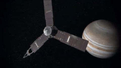
Let Us See Jupiter Through Your Eyes

Our Juno spacecraft will fly over Jupiter’s Great Red Spot on July 10 at 10:06 p.m. EDT. This will be humanity’s first up-close and personal view of the gas giant’s iconic 10,000-mile-wide storm, which has been monitored since 1830 and possibly existing for more than 350 years.

The data collection of the Great Red Spot is part of Juno’s sixth science flyby over Jupiter’s mysterious cloud tops. Perijove (the point at which an orbit comes closest to Jupiter’s center) will be July 10 at 9:55 p.m. EDT.

At the time of perijove, Juno will be about 2,200 miles above the planet’s cloud tops. Eleven minutes and 33 seconds later…Juno will have covered another 24,713 miles and will be directly above the coiling crimson cloud tops of the Great Red Spot. The spacecraft will pass about 5,600 miles above its clouds.
When will we see images from this flyby?
During the flyby, all eight of the spacecraft’s instruments will be turned on, as well as its imager, JunoCam. Because the spacecraft will be collecting data with its Microwave Radiometer (MWR), which measures radio waves from Jupiter’s deep atmosphere, we cannot downlink information during the pass. The MWR can tell us how much water there is and how material is moving far below the cloud tops.
During the pass, all data will be stored on-board…with a downlink planned afterwards. Once the downlink begins, engineering data from the spacecraft’s instruments will come to Earth first, followed by images from JunoCam.
The unprocessed, raw images will be located HERE, on approximately July 14. Follow @NASAJuno on Twitter for updates.
Did you know you can download and process these raw images?
We invite the public to act as a virtual imaging team…participating in key steps of the process, from identifying features of interest to sharing the finished images online. After JunoCam data arrives on Earth, members of the public can process the images to create color pictures. The public also helps determine which points on the planet will be photographed. Learn more about voting on JunoCam’s next target HERE.

JunoCam has four filters: red, green, blue and near-infrared. We get red, green and blue strips on one spacecraft rotation (the spacecraft rotation rate is 2 revolutions per minute) and the near-infrared strips on the second rotation. To get the final image product, the strips must be stitched together and the colors lined up.
Anything from cropping to color enhancing to collaging is fair game. Be creative!
Submit your images to Juno_outreach@jpl.nasa.gov to be featured on the Mission Juno website!
Check out some of these citizen-scientist processed images from previous Juno orbits:

Credit: Sean Doran (More)

Credit: Amelia Carolina (More)

Credit: Michael Ranger (More)

Credit: Jason Major (More)
Make sure to follow us on Tumblr for your regular dose of space: http://nasa.tumblr.com
-
 mona-vainy liked this · 2 years ago
 -
 anthigua liked this · 3 years ago
 -
 thesciencenerd liked this · 4 years ago
 -
 it-getsweirder liked this · 4 years ago
 -
 studywzubi liked this · 4 years ago
 -
 innerfa18eww2tarawadean liked this · 5 years ago
 -
 unknown-uwoit liked this · 5 years ago
 -
 apostelleeducation-blog liked this · 5 years ago
 -
 agentemp4 liked this · 5 years ago
 -
 61peepsonaroad liked this · 5 years ago
 -
 zataradaderler liked this · 5 years ago
 -
 mortadelino liked this · 5 years ago
 -
 eveesnorlax42-blog liked this · 5 years ago
 -
 mynameisgabebutthatstaken liked this · 5 years ago
 -
 chatdog69-blog liked this · 5 years ago
 -
 motherfire reblogged this · 5 years ago
 -
 spacetimewithstuartgary reblogged this · 5 years ago
 -
 mrjeorge liked this · 5 years ago
 -
 multifandombi liked this · 5 years ago
 -
 haxy-blog1 liked this · 5 years ago
 -
 ghostlineage liked this · 5 years ago
 -
 thewondersofspace reblogged this · 5 years ago
 -
foxdiggler liked this · 5 years ago
-
 nerdyshapeshifter liked this · 5 years ago
 -
 honeylemony liked this · 5 years ago
 -
 andromeda1023 reblogged this · 5 years ago
 -
 adt-space reblogged this · 5 years ago
 -
 eeveelov liked this · 5 years ago
 -
 synn8 liked this · 5 years ago
 -
 kanzaki19 liked this · 5 years ago
 -
 lex-1804 liked this · 5 years ago
 -
 smol-bean-dragon-hoard liked this · 5 years ago
 -
 star-bles liked this · 5 years ago
 -
 spilloverlove liked this · 5 years ago
 -
 getsmashed reblogged this · 5 years ago
 -
getsmashed liked this · 5 years ago
-
 fira315 liked this · 5 years ago
 -
 isaestudos-blog liked this · 5 years ago
Explore the universe and discover our home planet with the official NASA Tumblr account
1K posts