The Island Named After A Satellite
The Island Named After a Satellite
It is so small that you cannot see it on Google maps. It measures 25 by 45 meters (27 by 49 yards), about half the size of a football field. This barren bit of rock off the coast of Canada also has an unusual namesake: the Landsat 1 satellite. The small size is actually what made the island notable in 1973, when it was initially discovered. Well, that, and the polar bear trying to eat one of the surveyors.
Betty Fleming, a researcher with the Topographic Survey of Canada, was hunting for uncharted islands and rocks amidst data from the new Landsat 1 satellite. She was particularly interested in the new satellite's ability to find small features. Working with the Canadian Hydrographic Service, Fleming scanned images of the Labrador coast, an area that was poorly charted. About 20 kilometers (12 miles) offshore, the satellite detected a tiny, rocky island. Surveyors were sent to verify the existence of the island and encountered a hungry polar bear on the island. The surveyor quickly retreated. Eventually, the island became known as “Landsat Island,” after the satellite that discovered it. Watch the video to learn more about Betty Fleming and how Landsat Island was discovered by satellite and ground surveyors.
For more details about Landsat Island, read the full stories here:
The Island Named After a Satellite
The Unsung Woman Who Discovered an Unknown Island
Make sure to follow us on Tumblr for your regular dose of space: http://nasa.tumblr.com.
More Posts from Nasa and Others
Back to School Resources
Need help with your science homework? We’ve got you covered! Here are some out-of-this world (pun intended) resources for your science and space questions.
Let’s take a look…
NASA Space Place

From questions like “Why does Saturn have rings?” to games that allow you to explore different galaxies, NASA Space Place has a variety of content for elementary-age kids, parents and anyone who likes science and technology topics.
Visit the NASA Space Place website or follow @NASASpacePlace on Twitter.
SciJinks

Targeting middle-school students and teachers, this NOAA and NASA partnership has games and useful information about weather and other Earth science subjects.
Visit the SciJinks website or follow @SciJinks on Twitter.
NASA Education

The NASA Education website includes an A-Z list of education opportunities that we offer throughout the year, as well as education programs, events and resources for both students and educators.
We have a diverse set of resources for multiple age groups:
Grades K-4
Grades 5-8
Grades 9-12
Higher Education
Informal Education
Visit the NASA Education website or follow @NASAedu on Twitter.
Want to get NASA Education materials for your classroom? Click HERE.
A Year of Education on the International Space Station

Although on different crews, astronauts Joe Acaba and Ricky Arnold - both former teachers - will work aboard the International Space Station. K-12 and higher education students and educators can do NASA STEM activities related to the station and its role in our journey to Mars. Click HERE for more.
Sally Ride EarthKAM

Also on the International Space Station, the Sally Ride EarthKAM @ Space Camp allows students to program a digital camera on board the space station to photograph a variety of geographical targets for study in the classroom.
Registration is now open until Sept. 25 for the Sept. 26-30 mission. Click HERE for more.
NASA eClips™

NASA eClips™ are short, relevant educational video segments. These videos inspire and engage students, helping them see real world connections by exploring current applications of science, technology, engineering and mathematics, or STEM, topics. The programs are produced for targeted audiences: K-5, 6-8, 9-12 and the general public.
Space Operations Learning Center

The Space Operations Learning Center teaches school-aged students the basic concepts of space operations using the web to present this educational content in a fun and engaging way for all grade levels. With fourteen modules, there’s lots to explore for all ages.
The Mars Fun Zone

The Mars Fun Zone is a compilation of Red Planet-related materials that engage the explorer inside every kid through activities, games, and educational moments.
Fly Away with NASA Aeronautics

Frequent flyer or getting ready to earn your first set of wings? From children’s books for story time to interactive flight games, we’ve got Aeronautics activities for students of all ages that are sure to inspire future scientists, mathematicians and engineers.
On Pinterest? We have a board that highlights NASA science, technology, engineering and math (STEM) lessons, activities, tools and resources for teachers, educators and parents.
Check it out here: https://www.pinterest.com/nasa/nasa-for-educators/
Make sure to follow us on Tumblr for your regular dose of space: http://nasa.tumblr.com.
Did you have a favorite astronaut as a kid? If not, who were your inspirations? :)
Of course Mae Jemison was an inspiration, but I didn’t have a favorite. Because how do you pick out of such a great group?

🌊🌊🌊 This natural-color image captured May 17 near the coast of Guinea-Bissau in West Africa shows estuaries branching out like a network of roots from a plant. Crossfading to a data visualization helps reveals water clarity due to dissolved organic matter in Guinea-Bissau.
With their long tendrils, the rivers meander through the country’s lowland plains to join the Atlantic Ocean. On the way, they carry water, nutrients, but also sediments out from the land. These estuaries play an important role in agriculture for this small country that is mostly made up of flat terrain. While the coastal valleys can flood often during the rainiest part of the year in the summer, the rain makes the valleys good locations for farming, especially rice cultivation. Using satellite data, researchers continue to observe the country's change in terrain and as a result, they're documenting a regrowth of previously eroded coastal areas.
Learn more
Make sure to follow us on Tumblr for your regular dose of space: http://nasa.tumblr.com
Vice President Mike Pence visited our Kennedy Space Center in Florida today. While there, he delivered remarks to the workforce and toured our complex to see progress toward sending humans deeper into space, and eventually to Mars. He also had the opportunity to see our work with commercial companies to launch humans from U.S. soil to the International Space Station.
How Do You Solve a Problem Like Dark Energy?

Here’s the deal — the universe is expanding. Not only that, but it’s expanding faster and faster due to the presence of a mysterious substance scientists have named “dark energy.”
But before we get to dark energy, let’s first talk a bit about the expanding cosmos. It started with the big bang — when the universe started expanding from a hot, dense state about 13.8 billion years ago. Our universe has been getting bigger and bigger ever since. Nearly every galaxy we look at is zipping away from us, caught up in that expansion!

The expansion, though, is even weirder than you might imagine. Things aren’t actually moving away from each other. Instead, the space between them is getting larger.
Imagine that you and a friend were standing next to each other. Just standing there, but the floor between you was growing. You two aren’t technically moving, but you see each other moving away. That’s what’s happening with the galaxies (and everything else) in our cosmos ... in ALL directions!

Astronomers expected the expansion to slow down over time. Why? In a word: gravity. Anything that has mass or energy has gravity, and gravity tries to pull stuff together. Plus, it works over the longest distances. Even you, reading this, exert a gravitational tug on the farthest galaxy in the universe! It’s a tiny tug, but a tug nonetheless.
As the space between galaxies grows, gravity is trying to tug the galaxies back together — which should slow down the expansion. So, if we measure the distance of faraway galaxies over time, we should be able to detect if the universe's growth rate slows down.

But in 1998, a group of astronomers measured the distance and velocity of a number of galaxies using bright, exploding stars as their “yardstick.” They found out that the expansion was getting faster.
Not slowing down.
Speeding up.

⬆️ This graphic illustrates the history of our expanding universe. We do see some slowing down of the expansion (the uphill part of the graph, where the roller coaster is slowing down). However, at some point, dark energy overtakes gravity and the expansion speeds up (the downhill on the graph). It’s like our universe is on a giant roller coaster ride, but we’re not sure how steep the hill is!

Other researchers also started looking for signs of accelerated expansion. And they found it — everywhere. They saw it when they looked at individual stars. They saw it in large scale structures of the universe, like galaxies, galaxy groups and clusters. They even saw it when they looked at the cosmic microwave background (that’s what’s in this image), a "baby picture" of the universe from just a few hundred thousand years after the big bang.
If you thought the roller coaster was wild, hold on because things are about to get really weird.
Clearly, we were missing something. Gravity wasn’t the biggest influence on matter and energy across the largest scales of the universe. Something else was. The name we’ve given to that “something else” is dark energy.

We don’t know exactly what dark energy is, and we’ve never detected it directly. But we do know there is a lot of it. A lot. If you summed up all the “stuff” in the universe — normal matter (the stuff we can touch or observe directly), dark matter, and dark energy — dark energy would make up more than two-thirds of what is out there.
That’s a lot of our universe to have escaped detection!
Researchers have come up with a few dark energy possibilities. Einstein discarded an idea from his theory of general relativity about an intrinsic property of space itself. It could be that this bit of theory got dark energy right after all. Perhaps instead there is some strange kind of energy-fluid that fills space. It could even be that we need to tweak Einstein’s theory of gravity to work at the largest scales.
We’ll have to stay tuned as researchers work this out.

Our Wide Field Infrared Survey Telescope (WFIRST) — planned to launch in the mid-2020s — will be helping with the task of unraveling the mystery of dark energy. WFIRST will map the structure and distribution of matter throughout the cosmos and across cosmic time. It will also map the universe’s expansion and study galaxies from when the universe was a wee 2-billion-year-old up to today. Using these new data, researchers will learn more than we’ve ever known about dark energy. Perhaps even cracking open the case!
You can find out more about the history of dark energy and how a number of different pieces of observational evidence led to its discovery in our Cosmic Times series. And keep an eye on WFIRST to see how this mystery unfolds.
Make sure to follow us on Tumblr for your regular dose of space: http://nasa.tumblr.com
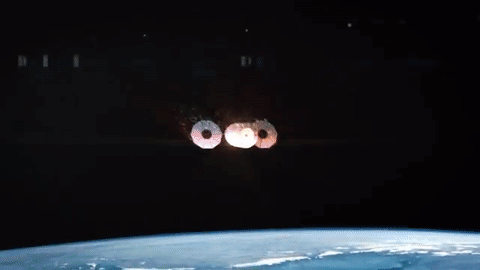
How will Cygnus Spacecraft Dock to Space Station?
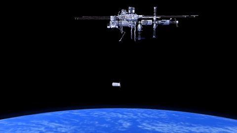
Orbital ATK’s Cygnus CRS-6 spacecraft launched to the International Space Station on March 22.
Cygnus will carry almost 7,500 pounds of science and research, crew supplies and vehicle hardware to the orbiting laboratory.
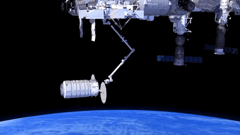
After launch in Florida, the spacecraft will arrive to the station on Saturday, March 26. Upon arrival, NASA astronaut and Expedition 46 Commander Tim Kopra will capture Cygnus at about 6:40 a.m. using the space station's Canadarm2 robotic arm to take hold of the spacecraft. Astronaut Tim Peake of ESA (European Space Agency) will support Kopra in a backup position.
Installation (when Cygnus is connected to space station) is expected to begin at 9:25 a.m. NASA TV coverage for installation resumes at 9:15 a.m.
After the Cygnus spacecraft is berthed (connected) to the space station, the contents will be emptied and brought inside for use. Any trash that is on the space station, can be put inside the empty Cygnus before it is undocked from station and sent to burn up in Earth’s atmosphere.
Watch Capture
You can watch the capture of Orbital ATK’s Cygnus spacecraft online. Stream live coverage starting at 5:30 a.m. EDT on Saturday, March 26. Capture is scheduled for 6:40 a.m.
Tune in again at 9:15 a.m. to watch #Cygnus installation to the station.
Watch online: nasa.gov/nasatv
Make sure to follow us on Tumblr for your regular dose of space: http://nasa.tumblr.com
Ever get a random craving for a food when in space?
How Do You Stay Fit on a Mission to Mars?
This mini exercise device could be the key!
Onboard the International Space Station, astronauts need to work out to maintain their bone density and muscle mass, usually exercising 2 hours every single day. Throughout the week, they exercise on three different pieces of equipment--a bike, a treadmill and the Advanced Restive Exercise Device (ARED).

All these devices are needed to keep an astronaut healthy.
However, deep-space vehicles like our Orion Spacecraft aren’t as roomy as station, so everything — including exercise equipment — needs to be downsized. The Miniature Exercise Device (MED-2) is getting us one step closer to being able to keep astronauts’ bodies healthy on long journeys to the moon, Mars and beyond.

MED-2 is a compact, all-in-one exercise device that we developed and will be launching to the space station Tuesday, March 22. Onboard the station, we’ll see how MED-2 will perform in microgravity and how it will need to be further adapted for our Journey to Mars. However, it’s already pretty well equipped for deep space missions.
So what makes MED-2 so great for deep space travel and our Journey to Mars?
1. It is an all-in-one exercise device, meaning it can do both aerobic and resistive workouts. When we go to Mars, the less equipment we need, the better.

2. It's incredibly light. The MED-2 weighs only 65 pounds, and every pound counts during space missions.

3. It has 5 - 350 pounds of resistance, despite weighing only 65 pounds. Astronauts don’t all lift the same amount, making the flexibility in MED-2’s “weights” essential.

4. It's tiny. (Hence its name Miniature Exercise Device.) Not only is MED-2 incredibly light, but it also won't take up a lot of space on any craft.

5. It powers itself. During an aerobic workout, the device charges, and then that power is used to run the resistive exercises. When traveling to space, it's good when nothing goes to waste, and now astronauts' workouts will help power the Journey to Mars.

MED-2 is only one of many devices and experiments flying on Orbital ATK’s Cygnus spacecraft. To find out more about the science on the space station, follow @ISS_Research and @Space_Station on Twitter.
Make sure to follow us on Tumblr for your regular dose of space: http://nasa.tumblr.com
Hurricanes Have No Place to Hide, Thanks to Better Satellite Forecasts

If you’ve ever looked at a hurricane forecast, you’re probably familiar with “cones of uncertainty,” the funnel-shaped maps showing a hurricane’s predicted path. Thirty years ago, a hurricane forecast five days before it made landfall might have a cone of uncertainty covering most of the East Coast. The result? A great deal of uncertainty about who should evacuate, where it was safe to go, and where to station emergency responders and their equipment.

Over the years, hurricane forecasters have succeeded in shrinking the cone of uncertainty for hurricane tracks, with the help of data from satellites. Polar-orbiting satellites, which fly nearly directly above the North and South Poles, are especially important in helping cut down on forecast error.

The orbiting electronic eyeballs key to these improvements: the Joint Polar Satellite System (JPSS) fleet. A collaborative effort between NOAA and NASA, the satellites circle Earth, taking crucial measurements that inform the global, regional and specialized forecast models that have been so critical to hurricane track forecasts.

The forecast successes keep rolling in. From Hurricanes Harvey, Irma and Maria in 2017 through Hurricanes Florence and Michael in 2018, improved forecasts helped manage coastlines, which translated into countless lives and property saved. In September 2018, with the help of this data, forecasters knew a week ahead of time where and when Hurricane Florence would hit. Early warnings were precise enough that emergency planners could order evacuations in time — with minimal road clogging. The evacuations that did not have to take place, where residents remained safe from the hurricane’s fury, were equally valuable.

The satellite benefits come even after the storms make landfall. Using satellite data, scientists and forecasters monitor flooding and even power outages. Satellite imagery helped track power outages in Puerto Rico after Hurricane Maria and in the Key West area after Hurricane Irma, which gave relief workers information about where the power grid was restored – and which regions still lacked electricity.

Flood maps showed the huge extent of flooding from Hurricane Harvey and were used for weeks after the storm to monitor changes and speed up recovery decisions and the deployment of aid and relief teams.

As the 2019 Atlantic hurricane season kicks off, the JPSS satellites, NOAA-20 and Suomi-NPP, are ready to track hurricanes and tropical cyclones as they form, intensify and travel across the ocean – our eyes in the sky for severe storms.
For more about JPSS, follow @JPSSProgram on Twitter and facebook.com/JPSS.Program, or @NOAASatellites on Twitter and facebook.com/NOAASatellites.
Make sure to follow us on Tumblr for your regular dose of space: http://nasa.tumblr.com.
10 Things to Know About Explorer 1, America's First Satellite
Sixty years ago, the hopes of Cold War America soared into the night sky as a rocket lofted skyward above Cape Canaveral, a soon-to-be-famous barrier island off the Florida coast.
1. The Original Science Robot

Sixty years ago this week, the United States sent its first satellite into space on Jan. 31, 1958. The spacecraft, small enough to be held triumphantly overhead, orbited Earth from as far as 1,594 miles (2,565 km) above and made the first scientific discovery in space. It was called, appropriately, Explorer 1.
2. Why It's Important

The world had changed three months before Explorer 1's launch, when the Soviet Union lofted Sputnik into orbit on Oct. 4, 1957. That satellite was followed a month later by a second Sputnik spacecraft. All of the missions were inspired when an international council of scientists called for satellites to be placed in Earth orbit in the pursuit of science. The Space Age was on.
3. It...Wasn't Easy

When Explorer 1 launched, we (NASA) didn't yet exist. It was a project of the U.S. Army and was built by Caltech's Jet Propulsion Laboratory (JPL) in Pasadena, California. After the Sputnik launch, the Army, Navy and Air Force were tasked by President Eisenhower with getting a satellite into orbit within 90 days. The Navy's Vanguard Rocket, the first choice, exploded on the launch pad Dec. 6, 1957.
4. The People Behind Explorer 1

University of Iowa physicist James Van Allen, whose proposal was chosen for the Vanguard satellite, had made sure his scientific instrument—a cosmic ray detector—would fit either launch vehicle. Wernher von Braun, working with the Army Ballistic Missile Agency in Alabama, directed the design of the Redstone Jupiter-C launch rocket, while JPL Director William Pickering oversaw the design of Explorer 1 and other upper stages of the rocket. JPL was also responsible for sending and receiving communications from the spacecraft.
5. All About the Science

Explorer 1's science payload took up 37.25 inches (95 cm) of the satellite's total 80.75 inches (2.05 meters). The main instruments were a cosmic-ray detector; internal, external and nose-cone temperature sensors; a micrometeorite impact microphone; a ring of micrometeorite erosion gauges; and two transmitters. There were two antennas in the body of the satellite and its four flexible whips formed a turnstile antenna that extended with the rotation of the satellite. Electrical power was provided by batteries that made up 40 percent of the total payload weight.
6. At the Center of a Space Doughnut

The first scientific discovery in space came from Explorer 1. Earth is surrounded by radiation belts of electrons and charged particles, some of them moving at nearly the speed of light, about 186,000 miles (299,000 km) per second. The two belts are shaped like giant doughnuts with Earth at the center. Data from Explorer 1 and Explorer 3 (launched March 26, 1958) led to the discovery of the inner radiation belt, while Pioneer 3 (Dec. 6, 1958) and Explorer IV (July 26, 1958) provided additional data, leading to the discovery of the outer radiation belt. The radiation belts can be hazardous for spacecraft, but they also protect the planet from harmful particles and energy from the Sun.
7. 58,376 Orbits

Explorer 1's last transmission was received May 21, 1958. The spacecraft re-entered Earth's atmosphere and burned up on March 31, 1970, after 58,376 orbits. From 1958 on, more than 100 spacecraft would fall under the Explorer designation.
8. Find Out More!

Want to know more about Explorer 1? Check out the website and download the poster celebrating 60 years of space science. go.nasa.gov/Explorer1
9. Hold the Spacecraft In Your Hands

Create your own iconic Explorer 1 photo (or re-create the original), with our Spacecraft 3D app. Follow @NASAEarth this week to see how we #ExploreAsOne. https://go.nasa.gov/2BmSCWi
10. What's Next?

All of our missions can trace a lineage to Explorer 1. This year alone, we're going to expand the study of our home planet from space with the launch of two new satellite missions (GRACE-FO and ICESat-2); we're going back to Mars with InSight; and the Transiting Exoplanet Survey Satellite (TESS) will search for planets outside our solar system by monitoring 200,000 bright, nearby stars. Meanwhile, the Parker Solar Probe will build on the work of James Van Allen when it flies closer to the Sun than any mission before.
Make sure to follow us on Tumblr for your regular dose of space: http://nasa.tumblr.com.
-
 rosebella2016 liked this · 3 years ago
 -
 itsupforubaby reblogged this · 4 years ago
 -
 loststolenorstrayed liked this · 5 years ago
 -
 vaityadil liked this · 5 years ago
 -
 avaant-gaarde liked this · 5 years ago
 -
 nyctolemon liked this · 5 years ago
 -
 unknown-uwoit liked this · 5 years ago
 -
 heavymetalchemist reblogged this · 5 years ago
 -
 keeper-of-drowned-men liked this · 5 years ago
 -
 whetstonefires liked this · 5 years ago
 -
 beatrice-otter reblogged this · 5 years ago
 -
 kimbermcleod reblogged this · 5 years ago
 -
 natscapegalore liked this · 5 years ago
 -
 cosmic40 liked this · 5 years ago
 -
 katiegairl23-blog liked this · 5 years ago
 -
 versidue liked this · 5 years ago
 -
 bosstowners reblogged this · 5 years ago
 -
 uomemuniverso-eu-blog liked this · 5 years ago
 -
 cherryobvious liked this · 5 years ago
 -
 pachelbelsheadcanon reblogged this · 5 years ago
 -
 hreremuswarlock liked this · 5 years ago
 -
 yesilovedeath liked this · 5 years ago
 -
 max39211 liked this · 5 years ago
 -
 catyuy reblogged this · 5 years ago
 -
 mercurywaterblue liked this · 5 years ago
 -
 awlwren liked this · 5 years ago
 -
 jepergola liked this · 5 years ago
 -
kimbermcleod liked this · 5 years ago
-
 applepieblackbirdfly liked this · 5 years ago
 -
 delightfulpaperpost liked this · 5 years ago
 -
 den1990 reblogged this · 5 years ago
 -
 squooshypilot liked this · 5 years ago
 -
 koolkiddo33-blog liked this · 5 years ago
 -
 basementeye-s liked this · 5 years ago
 -
 ptsd-is-a-bitch liked this · 5 years ago
 -
 stopscaringsmithers liked this · 5 years ago
 -
 gaieess02-blog liked this · 5 years ago
 -
 ipissoncomputers liked this · 5 years ago
Explore the universe and discover our home planet with the official NASA Tumblr account
1K posts