Your personal Tumblr journey starts here
Timelapse - Blog Posts
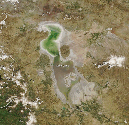
Reviving the Shriveled Lake Urmia
Once the second-largest saltwater lake in the Middle East, Lake Urmia attracted birds and bathers to bask in its turquoise waters in northwest Iran. Then beginning in the 1970s, nearly three decades of drought and high water demands on the lake shriveled the basin, shrinking it by 80 percent. Recent torrential rains have replenished the water levels of this aquatic gem once known as “the turquoise solitaire of Azerbaijan.”
The animation above shows Lake Urmia on April 9, 2018, and April 12, 2019. The images were acquired by the Moderate Resolution Imaging Spectroradiometer (MODIS) on our Terra satellite. Officials report that the lake’s surface area reached roughly 3,000 square kilometers (1,200 square miles) in April 2019—expanding its volume nearly two-fold from a year ago.
Read more about Lake Urmia here.
Make sure to follow us on Tumblr for your regular dose of space: http://nasa.tumblr.com.

During a recent close flyby of the gas giant Jupiter, our Juno spacecraft captured this stunning series of images showing swirling cloud patterns on the planet’s south pole. At first glance, the series might appear to be the same image repeated. But closer inspection reveals slight changes, which are most easily noticed by comparing the far-left image with the far-right image.
Directly, the images show Jupiter. But, through slight variations in the images, they indirectly capture the motion of the Juno spacecraft itself, once again swinging around a giant planet hundreds of millions of miles from Earth.
Juno captured this color-enhanced time-lapse sequence of images on Feb. 7 between 10:21 a.m. and 11:01 a.m. EST. At the time, the spacecraft was between 85,292 to 124,856 miles (137,264 to 200,937 kilometers) from the tops of the clouds of the planet with the images centered on latitudes from 84.1 to 75.5 degrees south.
Credit: NASA/JPL-Caltech/SwRI/MSSS/Gerald Eichstädt
Make sure to follow us on Tumblr for your regular dose of space: http://nasa.tumblr.com.
Much of the western United States began the morning with the view of a super blue blood moon total lunar eclipse. In this silent time lapse video, the complete eclipse is seen over NASA's Jet Propulsion Laboratory, located at the base of the San Gabriel Mountains near Pasadena, California. This Jan. 31 full moon was special for three reasons: it was the third in a series of “supermoons,” when the Moon is closer to Earth in its orbit -- known as perigee -- and about 14 percent brighter than usual. It was also the second full moon of the month, commonly known as a “blue moon.” The super blue moon will pass through Earth’s shadow to give viewers in the right location a total lunar eclipse. While the Moon is in the Earth’s shadow it will take on a reddish tint, known as a “blood moon.”
Credits: NASA/JPL-Caltech
Make sure to follow us on Tumblr for your regular dose of space: http://nasa.tumblr.com.
Our pale blue dot, planet Earth, is seen in this video captured by NASA astronaut Jack Fischer from his unique vantage point on the International Space Station. From 250 miles above our home planet, this time-lapse imagery takes us over the Pacific Ocean’s moon glint and above the night lights of San Francisco, CA. The thin hue of our atmosphere is visible surrounding our planet with a majestic white layer of clouds sporadically seen underneath.
The International Space Station is currently home to 6 people who are living and working in microgravity. As it orbits our planet at 17,500 miles per hour, the crew onboard is conducting important research that benefits life here on Earth.
Make sure to follow us on Tumblr for your regular dose of space: http://nasa.tumblr.com
Using a fleet of research aircraft, our Operation IceBridge images Earth's polar ice to better understand connections between polar regions and the global climate system. IceBridge studies annual changes in thickness of sea ice, glaciers and ice sheets. IceBridge bridges the gap between the ICESat missions.
Seen here is a time-lapse view of a glacier-run from the cockpit of our P-3 Orion aircraft taken during a May 8, 2017 flight over Greenland's Southeast glaciers.
Video credit: NASA/Gerrit Everson
Take a look back at this season’s Arctic ice survey HERE.
Make sure to follow us on Tumblr for your regular dose of space: http://nasa.tumblr.com