The Moon In Motion
The Moon in Motion
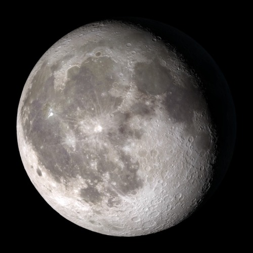
Happy New Year! And happy supermoon! Tonight, the Moon will appear extra big and bright to welcome us into 2018 – about 6% bigger and 14% brighter than the average full Moon. And how do we know that? Well, each fall, our science visualizer Ernie Wright uses data from the Lunar Reconnaissance Orbiter (LRO) to render over a quarter of a million images of the Moon. He combines these images into an interactive visualization, Moon Phase and Libration, which depicts the Moon at every day and hour for the coming year.
Want to see what the Moon will look like on your birthday this year? Just put in the date, and even the hour (in Universal Time) you were born to see your birthday Moon.
Our Moon is quite dynamic. In addition to Moon phases, our Moon appears to get bigger and smaller throughout the year, and it wobbles! Or at least it looks that way to us on Earth. This wobbling is called libration, from the Latin for ‘balance scale’ (libra). Wright relies on LRO maps of the Moon and NASA orbit calculations to create the most accurate depiction of the 6 ways our Moon moves from our perspective.
1. Phases

The Moon phases we see on Earth are caused by the changing positions of the Earth and Moon relative to the Sun. The Sun always illuminates half of the Moon, but we see changing shapes as the Moon revolves around the Earth. Wright uses a software library called SPICE to calculate the position and orientation of the Moon and Earth at every moment of the year. With his visualization, you can input any day and time of the year and see what the Moon will look like!
2. Shape of the Moon

Check out that crater detail! The Moon is not a smooth sphere. It’s covered in mountains and valleys and thanks to LRO, we know the shape of the Moon better than any other celestial body in the universe. To get the most accurate depiction possible of where the sunlight falls on the lunar surface throughout the month, Wright uses the same graphics software used by Hollywood design studios, including Pixar, and a method called ‘raytracing’ to calculate the intricate patterns of light and shadow on the Moon’s surface, and he checks the accuracy of his renders against photographs of the Moon he takes through his own telescope.

3. Apparent Size

The Moon Phase and Libration visualization shows you the apparent size of the Moon. The Moon’s orbit is elliptical, instead of circular - so sometimes it is closer to the Earth and sometimes it is farther. You’ve probably heard the term “supermoon.” This describes a full Moon at or near perigee (the point when the Moon is closest to the Earth in its orbit). A supermoon can appear up to 14% bigger and brighter than a full Moon at apogee (the point when the Moon is farthest from the Earth in its orbit).
Our supermoon tonight is a full Moon very close to perigee, and will appear to be about 14% bigger than the July 27 full Moon, the smallest full Moon of 2018, occurring at apogee. Input those dates into the Moon Phase and Libration visualization to see this difference in apparent size!
4. East-West Libration
Over a month, the Moon appears to nod, twist, and roll. The east-west motion, called ‘libration in longitude’, is another effect of the Moon’s elliptical orbital path. As the Moon travels around the Earth, it goes faster or slower, depending on how close it is to the Earth. When the Moon gets close to the Earth, it speeds up thanks to an additional pull from Earth’s gravity. Then it slows down, when it’s farther from the Earth. While this speed in orbital motion changes, the rotational speed of the Moon stays constant.
This means that when the Moon moves faster around the Earth, the Moon itself doesn’t rotate quite enough to keep the same exact side facing us and we get to see a little more of the eastern side of the Moon. When the Moon moves more slowly around the Earth, its rotation gets a little ahead, and we see a bit more of its western side.
5. North-South Libration

The Moon also appears to nod, as if it were saying “yes,” a motion called ‘libration in latitude’. This is caused by the 5 degree tilt of the Moon’s orbit around the Earth. Sometimes the Moon is above the Earth’s northern hemisphere and sometimes it’s below the Earth’s southern hemisphere, and this lets us occasionally see slightly more of the northern or southern hemispheres of the Moon!
6. Axis Angle

Finally, the Moon appears to tilt back and forth like a metronome. The tilt of the Moon’s orbit contributes to this, but it’s mostly because of the 23.5 degree tilt of our own observing platform, the Earth. Imagine standing sideways on a ramp. Look left, and the ramp slopes up. Look right and the ramp slopes down.
Now look in front of you. The horizon will look higher on the right, lower on the left (try this by tilting your head left). But if you turn around, the horizon appears to tilt the opposite way (tilt your head to the right). The tilted platform of the Earth works the same way as we watch the Moon. Every two weeks we have to look in the opposite direction to see the Moon, and the ground beneath our feet is then tilted the opposite way as well.
So put this all together, and you get this:
Beautiful isn’t it? See if you can notice these phenomena when you observe the Moon. And keep coming back all year to check on the Moon’s changing appearance and help plan your observing sessions.
Follow @NASAMoon on Twitter to keep up with the latest lunar updates.
Make sure to follow us on Tumblr for your regular dose of space: http://nasa.tumblr.com.
More Posts from Nasa and Others

Update your phones with our #CountdownToMars wallpapers, like this one, today: https://www.nasa.gov/feature/perseverance-mars-rover-wallpaper-images/
It's LANDING DAY for our Perseverance Mars Rover and her mission to search for ancient signs of life on the Red Planet!
Watch LIVE coverage today starting at 2:15pm ET (18:15 UTC):
Make sure to follow us on Tumblr for your regular dose of space: http://nasa.tumblr.com
10 Ground-breaking Earth Satellite Images from 2018
In 2018, our satellites captured beautiful imagery from throughout the solar system and beyond. However, some of our favorite visualizations are of this very planet. While this list is by no means exhaustive, it does capture some Earth satellite images from this year that are both visually striking as well as scientifically informative. This list also represents a broad variety of Earth’s features, as well as satellite instrumentation. Take a journey with our eyes in the sky!
10. Hurricane Florence

Before making landfall, Hurricane Florence churned in the Atlantic for a full two weeks — making it among the longest-lived cyclones of the 2018 season. When it finally did hit land on Sep. 14, the storm devastated the southeastern U.S. coast with intense winds, torrential rains and severe flooding.
This natural-color image was acquired by MODIS on the Terra Satellite on Sep. 12, 2018.
Images like this, as well as other satellite information, were used to anticipate the impact of the storm. Our Disasters Program created flood proxy maps that were shared with the Federal Emergency Management Agency (FEMA) and the National Guard to estimate how many and which communities would be most affected by the storm, in order to help prepare recovery efforts ahead of time.
9. Australia’s Lake Eyre Basin

The Lake Eyre Basin covers one-sixth of Australia and is one of the world’s largest internally draining river systems. However, the rivers supported by this system are ephemeral, meaning that they only run for short periods of time following unpredictable rain — the rest of the time, the Basin is a dry, arid desert.
However, when the heavy rain comes, the basin erupts in an explosion of green. In this false-color image captured by the Operational Land Imager (OLI) on Landsat 8 on Apr. 25, 2018, you can see how the vegetation completely envelops the spaces where the water has receded. (Flood water is indicated by light blue, and vegetation is indicated by light green.)
Satellites are an excellent tool for tracking greening events that are followed by flooding. These events offer opportunities for predictive tools as well as recreation.
8. Alaska’s Chukchi Sea

A Monet painting comes to life as the Chukchi Sea swirls with microscopic marine algae.
This image was captured off the Alaskan coast by OLI on Landsat 8 on Jun. 18, 2018. After the Arctic sea ice breaks up each spring, the nutrient-rich Bering Sea water mixes with the nutrient-poor Alaskan coastal water. Each type of water brings with it a different type of phytoplankton and the surface waters have just enough light for the algae to populate and flourish. The result is these mesmerizing patterns of turquoise and green.
This image represents one piece of much larger, incredibly complex ecosystem. While one would not normally associate the breaking up of sea ice with phytoplankton blooms, it is an intricate process of the phytoplankton life cycle. The size of the blooms have varied greatly from year to year, and experts are unsure why. Images like these can help scientists track the development of these blooms and link it to other environmental changes.
7. Hawaii’s Kilauea

Sometimes fresh lava is best viewed in infrared.
This false-color image of Kilauea, captured by OLI on Landsat 8 on May 23, 2018, shows the infrared signal emitted by lava flowing toward the sea. The purple areas surrounding the glowing lava are clouds lit from below, indicating that this image was taken through a break in the clouds.
The Puʻu ʻŌʻō Kupaianaha eruption has been continuously spewing red-hot lava since 1983, making it the longest eruption at Kilauea in recorded history. However, new fissures opened up this year that forced many to evacuate the area. Hawaii’s largest lake evaporated in hours and hundreds of homes were destroyed in Vacationland and Kapoho.
Imagery, seismometers and ground-based instruments were used to track the underground movement of magma. Infrared imagery can be incredibly helpful in disasters like this when you to view data that cannot be observed with the naked eye.
6. California’s Woolsey Burn Scar

Nothing quite encapsulates the destruction of a wildfire like a photo from outer space.
This image of the Woolsey Fire aftermath in Southern California was captured on Nov. 18, 2018 by the Advanced Spaceborned Thermal Emission and Reflection Radiometer (ASTER) on the Terra satellite. This false-color infrared image has been enhanced to clearly show the burned vegetation (indicated by brown) and the vegetation that survived unscathed (indicated by green).
The Woolsey Fire clearly left its mark, with almost 152 square miles (394 square km) and 88% of the Santa Monica Mountains National Recreation Area badly burned. Images like this one can assist fire managers in the area plan for recovery.
5. Bangladesh’s Padma River

As the years go by, the Padma River grows and shrinks, twists and turns. It never has a fixed shape, and as a result, thousands of people must regularly adapt to the constant changes in the river’s 75-mile (130-km) shoreline.
This image captured on Jan. 20, 2018 by OLI on Landsat 8 depicts one of the major rivers of Bangladesh. For thirty years, scientists have been tracking the erosion of the river with satellite imagery. Combinations of shortwave infrared, near infrared, and visible light are used to detect differences year-to-year in width, depth, and shape of the river. Sometimes the river splits off, but then rejoins again later. These patterns are created by the river carrying and depositing sediment, shaping the curves of the path of water.
Monitoring the Padma River is going to become especially important as a new bridge development project advances in the Char Janajat area. Although the bridge will most certainly help shorten travel times for citizens, nobody is quite sure how the river erosion might affect the construction and vice versa.
4. Alaska’s Yakutat Glacier

It’s hard to believe that Harlequin Lake was once all dry land — but it only started to form once Yakutat Glacier started melting. The lake appeared at the beginning of the twentieth century, and has been growing rapidly ever since.
In this hauntingly beautiful image, captured on Sep. 21 2018 by OLI on Landsat 8, the effect of climate change is apparent — especially when compared to earlier images of the region.
Unless the climate warming starts to reverse very soon — which scientists consider very unlikely — Yakutat could be gone as soon as 2070.
3. South Africa’s Theewaterskloof

Cape Town is a seaside city planted on the tip of South Africa. It’s a city known for its beaches and biodiversity — it also almost became known as the first major city to officially run out of water.
This image of Cape Town’s largest reservoir — Theewaterskloof — was acquired on Jul. 9th, 2018 by OLI on Landsat 8. By the time this photo was taken, the city’s main reservoirs stood at 55%. This was a huge increase from where it stood just six months earlier: just 13%.
The severe water shortage in the region started in 2015, only to become more threatening after three successive and unusually dry years. The entire city was preparing for Day Zero — the day the tap water would be shut off.
Despite forecasts that Day Zero would arrive in April, a combination of heavier rains and local conservation efforts restored the majority of the reservoir.
2. Aerosol Earth

Aerosols are all around us. From the smoke from a fire, to the dust in the wind to the salt in sea spray — these solid particles and liquid droplets are always swirling in our atmosphere, oftentimes unseen.
The Goddard Earth Observing System Forward Processing (GEOS FP) model uses mathematical equations to model what is happening in our atmosphere. The inputs for its equations — temperature, moisture, wind, etc. — come from our satellites and ground sensors.
This visualization was compiled on Aug. 24, 2018 — obviously a busy day for aerosols in our atmosphere. Swirls of sea salt (indicated by blue) reveal typhoons Soulik and Cimaron heading straight towards South Korea and Japan. A haze of black carbon (indicated by red) suffuse from agricultural burning in Africa and large wildfires in North America. And clouds of dust (indicated by purple) float off the Sahara desert.
1. Camp Fire

With nearly a hundred fatalities, hundreds of thousands of acres burned and billions of dollars of damage, the world watched in horror as Camp Fire grew to become the most destructive California wildfire in recorded history.
This image was captured on Nov. 8, 2018 by OLI on Landsat 8 on the same day Camp Fire ignited. It consolidates both visible light and shortwave-infrared light in order to highlight the active fire. Strong winds and dry conditions literally fanned the flames and spread this wildfire like a rash.
This image has not only become the iconic portrait for Camp Fire, it is also sobering representation of how quickly a fire can grow out of control in a short amount of time. Even from space, you can almost smell the massive plumes of smoke and feel the heat of the fires.
Whether you realize it or not, our Earth satellite missions are collecting data everyday in order to monitor environmental changes and prepare for natural disasters. If your interest is piqued by this list, head over to the Earth Observatory. The Earth Observatory updates daily with fresh, new content — brought to you by none other than our eyes in the sky.
Make sure to follow us on Tumblr for your regular dose of space: http://nasa.tumblr.com
What is a Supermoon Lunar Eclipse?

We’ve told you that on Sept. 27 a supermoon lunar eclipse will occur in the U.S. And much of the world, but what does that mean?
One important note, is that this event can be referred to in many different ways:
Supermoon Lunar Eclipse
Super Blood Moon
Harvest Moon Eclipse
Supermoon Eclipse
All slightly different names, but apply to the same spectacular event that will occur this weekend.
Since it’s rare that both a supermoon and an lunar eclipse occur at the same time, let’s break it down.
1) Supermoon

A supermoon is a full or new moon that falls closest to the fall equinox, and is at its closest approach to the Earth. This results in the moon appearing up to 14% larger in diameter.
2) Lunar Eclipse

A lunar eclipse occurs when the moon passes directly behind the Earth into its shadow. This can give the moon a red tint.
3) A Supermoon Lunar Eclipse!

The combination of these two events does not happen very often. In fact, since 1900 a supermoon lunar eclipse has only happened 5 times! The last time this occurred was 1982, and if you miss the event this year, your next opportunity won’t come until 2033.
This year, the event will be visible from the Americas, Europe and Africa on the night of Sept. 27. Here’s a full schedule of the supermoon eclipse:

If it’s cloudy in your area on Sept. 27, don’t worry! NASA Television will be providing a live stream of the event, so you can tune in and enjoy the show.
For more information and resources on the supermoon lunar eclipse, visit our page on NASA.gov.
Make sure to follow us on Tumblr for your regular dose of space: http://nasa.tumblr.com
Cassini Spacecraft: Top Discoveries
Our Cassini spacecraft has been exploring Saturn, its stunning rings and its strange and beautiful moons for more than a decade.

Having expended almost every bit of the rocket propellant it carried to Saturn, operators are deliberately plunging Cassini into the planet to ensure Saturn’s moons will remain pristine for future exploration – in particular, the ice-covered, ocean-bearing moon Enceladus, but also Titan, with its intriguing pre-biotic chemistry.
Let’s take a look back at some of Cassini’s top discoveries:
Titan

Under its shroud of haze, Saturn’s planet-sized moon Titan hides dunes, mountains of water ice and rivers and seas of liquid methane. Of the hundreds of moons in our solar system, Titan is the only one with a dense atmosphere and large liquid reservoirs on its surface, making it in some ways more like a terrestrial planet.

Both Earth and Titan have nitrogen-dominated atmospheres – over 95% nitrogen in Titan’s case. However, unlike Earth, Titan has very little oxygen; the rest of the atmosphere is mostly methane and traced amounts of other gases, including ethane.

There are three large seas, all located close to the moon’s north pole, surrounded by numerous smaller lakes in the northern hemisphere. Just one large lake has been found in the southern hemisphere.
Enceladus

The moon Enceladus conceals a global ocean of salty liquid water beneath its icy surface. Some of that water even shoots out into space, creating an immense plume!

For decades, scientists didn’t know why Enceladus was the brightest world in the solar system, or how it related to Saturn’s E ring. Cassini found that both the fresh coating on its surface, and icy material in the E ring originate from vents connected to a global subsurface saltwater ocean that might host hydrothermal vents.

With its global ocean, unique chemistry and internal heat, Enceladus has become a promising lead in our search for worlds where life could exist.
Iapetus

Saturn’s two-toned moon Iapetus gets its odd coloring from reddish dust in its orbital path that is swept up and lands on the leading face of the moon.

The most unique, and perhaps most remarkable feature discovered on Iapetus in Cassini images is a topographic ridge that coincides almost exactly with the geographic equator. The physical origin of the ridge has yet to be explained...

It is not yet year whether the ridge is a mountain belt that has folded upward, or an extensional crack in the surface through which material from inside Iapetus erupted onto the surface and accumulated locally.
Saturn’s Rings

Saturn’s rings are made of countless particles of ice and dust, which Saturn’s moons push and tug, creating gaps and waves.

Scientists have never before studied the size, temperature, composition and distribution of Saturn’s rings from Saturn obit. Cassini has captured extraordinary ring-moon interactions, observed the lowest ring-temperature ever recorded at Saturn, discovered that the moon Enceladus is the source for Saturn’s E ring, and viewed the rings at equinox when sunlight strikes the rings edge-on, revealing never-before-seen ring features and details.
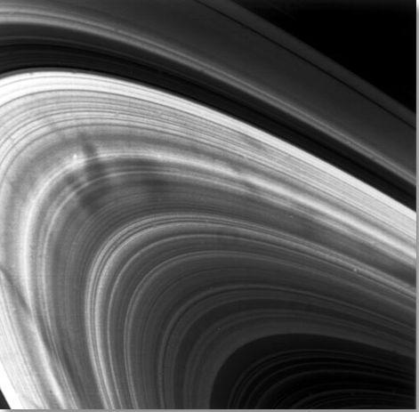
Cassini also studied features in Saturn’s rings called “spokes,” which can be longer than the diameter of Earth. Scientists think they’re made of thin icy particles that are lifted by an electrostatic charge and only last a few hours.
Auroras

The powerful magnetic field that permeates Saturn is strange because it lines up with the planet’s poles. But just like Earth’s field, it all creates shimmering auroras.

Auroras on Saturn occur in a process similar to Earth’s northern and southern lights. Particles from the solar wind are channeled by Saturn’s magnetic field toward the planet’s poles, where they interact with electrically charged gas (plasma) in the upper atmosphere and emit light.
Turbulent Atmosphere

Saturn’s turbulent atmosphere churns with immense storms and a striking, six-sided jet stream near its north pole.

Saturn’s north and south poles are also each beautifully (and violently) decorated by a colossal swirling storm. Cassini got an up-close look at the north polar storm and scientists found that the storm’s eye was about 50 times wider than an Earth hurricane’s eye.

Unlike the Earth hurricanes that are driven by warm ocean waters, Saturn’s polar vortexes aren’t actually hurricanes. They’re hurricane-like though, and even contain lightning. Cassini’s instruments have ‘heard’ lightning ever since entering Saturn orbit in 2004, in the form of radio waves. But it wasn’t until 2009 that Cassini’s cameras captured images of Saturnian lighting for the first time.

Cassini scientists assembled a short video of it, the first video of lightning discharging on a planet other than Earth.

Cassini’s adventure will end soon because it’s almost out of fuel. So to avoid possibly ever contaminating moons like Enceladus or Titan, on Sept. 15 it will intentionally dive into Saturn’s atmosphere.

The spacecraft is expected to lose radio contact with Earth within about one to two minutes after beginning its decent into Saturn’s upper atmosphere. But on the way down, before contact is lost, eight of Cassini’s 12 science instruments will be operating! More details on the spacecraft’s final decent can be found HERE.
Make sure to follow us on Tumblr for your regular dose of space: http://nasa.tumblr.com
That’s a wrap! Thanks for all the great questions.
Follow Serena on Twitter at @AstroSerena and follow the International Space Station on Twitter, Instagram and Facebook to keep up with all the cool stuff happening on our orbital laboratory.
What’s Up for June 2017?
Have a planet party and compare Saturn and Jupiter! We’ll show you where and when to point your telescope or binoculars to see these planets and their largest moons.

Meet at midnight to have a planetary party when Jupiter and Saturn are visible at the same time!

The best time will be after midnight on June 17. To see the best details, you’ll need a telescope.

Saturn will be at opposition on June 15, when Saturn, the Earth and the sun are in a straight line.

Opposition provides the best views of Saturn and several of its brightest moons. At the very least, you should be able to see Saturn’s moon Titan, which is larger and brighter than Earth’s moon.

As mentioned earlier, you’ll be able to see Jupiter and Saturn in the night sky this month. Through a telescope, you’ll be able to see the cloud bands on both planets. Saturn’s cloud bands are fainter than those on Jupiter.

You’ll also have a great view of Saturn’s Cassini Division, discovered by astronomer Giovanni Cassini in 1675, namesake of our Cassini spacecraft.

Our Cassini spacecraft has been orbiting the planet since 2004 and is on a trajectory that will ultimately plunge it into Saturn’s atmosphere on September 15, 2017, bringing the mission to a close.

Our Juno spacecraft recently completed its sixth Jupiter flyby. Using only binoculars you can observe Jupiter’s 4 Galilean moons - Io, Callisto, Ganymede and Europa.

To learn about What’s Up in the skies for June 2017, watch the full video:
For more astronomy events, check out NASA's Night Sky Network at https://nightsky.jpl.nasa.gov/.
Make sure to follow us on Tumblr for your regular dose of space: http://nasa.tumblr.com
10 Frequently Asked Questions About the James Webb Space Telescope
Got basic questions about the James Webb Space Telescope and what amazing things we’ll learn from it? We’ve got your answers right here!
The James Webb Space Telescope, or Webb, is our upcoming infrared space observatory, which will launch in 2021. It will spy the first luminous objects that formed in the universe and shed light on how galaxies evolve, how stars and planetary systems are born, and how life could form on other planets.

1. What is the James Webb Space Telescope?
Our James Webb Space Telescope is a giant space telescope that observes infrared light. Rather than a replacement for the Hubble Space Telescope, it’s a scientific successor that will complement and extend its discoveries.

Being able to see longer wavelengths of light than Hubble and having greatly improved sensitivity will let Webb look further back in time to see the first galaxies that formed in the early universe, and to peer inside dust clouds where stars and planetary systems are forming today.

2. What are the most exciting things we will learn?
We have yet to observe the era of our universe’s history when galaxies began to form.
We have a lot to learn about how galaxies got supermassive black holes in their centers, and we don't really know whether the black holes caused the galaxies to form or vice versa.

We can't see inside dust clouds with high resolution, where stars and planets are being born nearby, but Webb will be able to do just that.
We don't know how many planetary systems might be hospitable to life, but Webb could tell whether some Earth-like planets have enough water to have oceans.

We don't know much about dark matter or dark energy, but we expect to learn more about where the dark matter is now, and we hope to learn the history of the acceleration of the universe that we attribute to dark energy.
And then, there are the surprises we can't imagine!
3. Why is Webb an infrared telescope?
By viewing the universe at infrared wavelengths with such sensitivity, Webb will show us things never before seen by any other telescope. For example, it is only at infrared wavelengths that we can see the first stars and galaxies forming after the Big Bang.

And it is with infrared light that we can see stars and planetary systems forming inside clouds of dust that are opaque to visible light, such as in the above visible and infrared light comparison image of the Carina Nebula.
4. Will Webb take amazing pictures like Hubble? Can Webb see visible light?
YES, Webb will take amazing pictures! We are going to be looking at things we've never seen before and looking at things we have seen before in completely new ways.
The beauty and quality of an astronomical image depends on two things: the sharpness and the number of pixels in the camera. On both of these counts, Webb is very similar to, and in many ways better than, Hubble.

Additionally Webb can see orange and red visible light. Webb images will be different, but just as beautiful as Hubble's. Above, there is another comparison of infrared and visible light Hubble images, this time of the Monkey Head Nebula.
5. What will Webb's first targets be?
The first targets for Webb will be determined through a process similar to that used for the Hubble Space Telescope and will involve our experts, the European Space Agency (ESA), the Canadian Space Agency (CSA), and scientific community participants.

The first engineering target will come before the first science target and will be used to align the mirror segments and focus the telescope. That will probably be a relatively bright star or possibly a star field.
6. How does Webb compare with Hubble?
Webb is designed to look deeper into space to see the earliest stars and galaxies that formed in the universe and to look deep into nearby dust clouds to study the formation of stars and planets.

In order to do this, Webb has a much larger primary mirror than Hubble (2.5 times larger in diameter, or about 6 times larger in area), giving it more light-gathering power. It also will have infrared instruments with longer wavelength coverage and greatly improved sensitivity than Hubble.
Finally, Webb will operate much farther from Earth, maintaining its extremely cold operating temperature, stable pointing and higher observing efficiency than with the Earth-orbiting Hubble.
7. What will Webb tell us about planets outside our solar system? Will it take photos of these planets?
Webb will be able to tell us the composition of the atmospheres of planets outside our solar system, aka exoplanets. It will observe planetary atmospheres through the transit technique. A transit is when a planet moves across the disc of its parent star.

Webb will also carry coronographs to enable photography of exoplanets (planets outside our solar system) near bright stars (if they are big and bright and far from the star), but they will be only "dots," not grand panoramas. Coronographs block the bright light of stars, which could hide nearby objects like exoplanets.
Consider how far away exoplanets are from us, and how small they are by comparison to this distance! We didn’t even know what Pluto really looked like until we were able to send an observatory to fly right near it in 2015, and Pluto is in our own solar system!
8. Will we image objects in our own solar system?
Yes! Webb will be able to observe the planets at or beyond the orbit of Mars, satellites, comets, asteroids and objects in the distant, icy Kuiper Belt.
Many important molecules, ices and minerals have strong characteristic signatures at the wavelengths Webb can observe.

Webb will also monitor the weather of planets and their moons.
Because the telescope and instruments have to be kept cold, Webb’s protective sunshield will block the inner solar system from view. This means that the Sun, Earth, Moon, Mercury, and Venus, and of course Sun-grazing comets and many known near-Earth objects cannot be observed.
9. How far back will Webb see?

Webb will be able to see what the universe looked like around a quarter of a billion years (possibly back to 100 million years) after the Big Bang, when the first stars and galaxies started to form.
10. When will Webb launch and how long is the mission?
Webb will launch in 2021 from French Guiana on a European Space Agency Ariane 5 rocket.

Webb’s mission lifetime after launch is designed to be at least 5-1/2 years, and could last longer than 10 years. The lifetime is limited by the amount of fuel used for maintaining the orbit, and by the possibility that Webb’s components will degrade over time in the harsh environment of space.
Looking for some more in-depth FAQs? You can find them HERE.
Learn more about the James Webb Space Telescope HERE, or follow the mission on Facebook, Twitter and Instagram.
IMAGE CREDITS Carina Nebula: ESO/T. Preibisch Monkey Head Nebula: NASA, ESA, the Hubble Heritage Team (STScI/AURA), and J. Hester
Make sure to follow us on Tumblr for your regular dose of space: http://nasa.tumblr.com.
13 Reasons to Have an Out of this World Friday (the 13th)
1. Know that not all of humanity is bound to the ground

Since 2000, the International Space Station has been continuously occupied by humans. There, crew members live and work while conducting important research that benefits life on Earth.
2. Smart people are up all night working in control rooms all over NASA to ensure that data keeps flowing from our satellites

Our satellites help scientists study Earth and space. Satellites looking toward Earth provide information about clouds, oceans, land and ice. They also measure gases in the atmosphere, such as ozone and carbon dioxide, and the amount of energy that Earth absorbs and emits. And satellites monitor wildfires, volcanoes and their smoke.
Satellites that face toward space have a variety of jobs. Some watch for dangerous rays coming from the sun. Others explore asteroids and comets, the history of stars, and the origin of planets. Some satellites fly near or orbit other planets. These spacecraft may look for evidence of water on Mars or capture close-up pictures of Saturn’s rings.
3. When we are ready to send humans to Mars, they’ll have the most high tech space suits ever made

Our Z-2 Spacesuit is the newest prototype in its next-generation platform, the Z-series. Each iteration of the Z-series will advance new technologies that one day will be used in a suit worn by the first humans to step foot on the red planet.
4. When we need more space in space, it could be just like expanding a big high-tech balloon

The Bigelow Expandable Activity Module, or BEAM, leverages key innovations in lightweight and compact materials, departing from a traditional rigid metallic structure. Once attached to the International Space Station, the module would result in an additional 565 cubic feet of volume, which is about the size of a large family camping tent.
5. Even astronauts eat their VEGGIE's

The Vegetable Production System (VEGGIE) is a deployable plant growth unit capable of producing salad-type crops in space. Earlier this year, Expedition 44 crew members, sampled the red romaine lettuce from the VEGGIE plant growth system. This technology will provide future pioneers with a sustainable food supplement during long-duration exploration missions.
6. When you feel far away from home, you can think of the New Horizons spacecraft as it heads toward the Kuiper Belt…billions of miles away

Our New Horizons spacecraft completed its Pluto flyby on July 14, and has continued on its way toward the Kuiper Belt. The spacecraft continues to send back important data as it travels toward deeper space at more than 32,000 miles per hour, and is nearly 3.2 billion miles from Earth.
7. Earth has a magnetic field that largely protects it from the solar wind stripping away our atmosphere…unlike Mars

Recently announced findings from our MAVEN mission have identified the process that appears to have played a key role in the transition of the Martian climate from an early, warm and wet environment to the cold, arid planet Mars is today. MAVEN data have enabled researchers to determine the rate at which the Martian atmosphere currently is losing gas to space via stripping by the solar wind. Luckily, Earth has a magnetic field that largely protects it from this process.
8. Water bubbles look REALLY cool in space

Astronauts on the International Space Station dissolved an effervescent tablet in a floating ball of water, and captured images using a camera capable of recording four times the resolution of normal high-definition cameras. The higher resolution images and higher frame rate videos can reveal more information when used on science investigations, giving researchers a valuable new tool aboard the space station. This footage is one of the first of its kind.
9. Americans will launch from U.S. soil again with the Commercial Crew Program

Our Commercial Crew Program is working with the American aerospace industry as companies develop and operate a new generation of spacecraft and launch systems capable of carrying crews to low-Earth orbit and the International Space Station.
10. You can see a global image of your home planet…EVERY DAY

Once a day, we will post at least a dozen new color images of Earth acquired from 12 to 36 hours earlier. These images are taken by our EPIC camera from one million miles away on the Deep Space Climate Observatory (DSCOVR). Take a look HERE.
11. Over 18,000 people wanted to be astronauts and join us on the journey to Mars

More than 18,300 people applied to join our 2017 astronaut class, almost three times the number of applications received in 2012 for the most recent astronaut class, and far surpassing the previous record of 8,000 in 1978. Among this group are humanities next great explorers!
12. A lot of NASA-developed tech has been transferred for use to the public
Our Technology Transfer Program highlights technologies that were originally designed for our mission needs, but have since been introduced to the public market. HERE are a few spinoff technologies that you might not know about.
13. If all else fails, there’s this image of Psychedelic Pluto

This false color image of Pluto was created using a technique called principal component analysis. This effect highlights the many subtle color differences between Pluto’s distinct regions.
Make sure to follow us on Tumblr for your regular dose of space: http://nasa.tumblr.com
Save the Date: 2024 Total Solar Eclipse
On April 8, 2024, a total solar eclipse will travel through Mexico, cross the United States from Texas to Maine, and exit North America along Canada’s Atlantic coast. A total solar eclipse occurs when the Moon passes between the Sun and the Earth, completely blocking the face of the Sun. The sky will darken as if it were dawn or dusk.
Weather permitting, people throughout most of North and Central America, including all of the contiguous United States, will be able to view at least a partial solar eclipse. A partial solar eclipse is when the Moon only covers part of the Sun. People in Hawaii and parts of Alaska will also experience a partial solar eclipse. Click here to learn more about when and where the solar eclipse will be visible: go.nasa.gov/Eclipse2024Map
Not in the path of the eclipse? Join us online to watch the eclipse with NASA. Set a reminder to watch live: https://go.nasa.gov/3V2CQML
Make sure to follow us on Tumblr for your regular dose of space!
The Past, Present and Future of Exploration on Mars
Today, we’re celebrating the Red Planet! Since our first close-up picture of Mars in 1965, spacecraft voyages to the Red Planet have revealed a world strangely familiar, yet different enough to challenge our perceptions of what makes a planet work.

You’d think Mars would be easier to understand. Like Earth, Mars has polar ice caps and clouds in its atmosphere, seasonal weather patterns, volcanoes, canyons and other recognizable features. However, conditions on Mars vary wildly from what we know on our own planet.
Join us as we highlight some of the exploration on Mars from the past, present and future:
PAST
Viking Landers

Our Viking Project found a place in history when it became the first U.S. mission to land a spacecraft safely on the surface of Mars and return images of the surface. Two identical spacecraft, each consisting of a lander and an orbiter, were built. Each orbiter-lander pair flew together and entered Mars orbit; the landers then separated and descended to the planet’s surface.

Besides taking photographs and collecting other science data, the two landers conducted three biology experiments designed to look for possible signs of life.
Pathfinder Rover

In 1997, Pathfinder was the first-ever robotic rover to land on the surface of Mars. It was designed as a technology demonstration of a new way to deliver an instrumented lander to the surface of a planet. Mars Pathfinder used an innovative method of directly entering the Martian atmosphere, assisted by a parachute to slow its descent and a giant system of airbags to cushion the impact.

Pathfinder not only accomplished its goal but also returned an unprecedented amount of data and outlived its primary design life.
PRESENT
Spirit and Opportunity

In January 2004, two robotic geologists named Spirit and Opportunity landed on opposite sides of the Red Planet. With far greater mobility than the 1997 Mars Pathfinder rover, these robotic explorers have trekked for miles across the Martian surface, conducting field geology and making atmospheric observations. Carrying identical, sophisticated sets of science instruments, both rovers have found evidence of ancient Martian environments where intermittently wet and habitable conditions existed.

Both missions exceeded their planned 90-day mission lifetimes by many years. Spirit lasted 20 times longer than its original design until its final communication to Earth on March 22, 2010. Opportunity continues to operate more than a decade after launch.
Mars Reconnaissance Orbiter

Our Mars Reconnaissance Orbiter left Earth in 2005 on a search for evidence that water persisted on the surface of Mars for a long period of time. While other Mars missions have shown that water flowed across the surface in Mars’ history, it remained a mystery whether water was ever around long enough to provide a habitat for life.

In addition to using the rover to study Mars, we’re using data and imagery from this mission to survey possible future human landing sites on the Red Planet.
Curiosity

The Curiosity rover is the largest and most capable rover ever sent to Mars. It launched November 26, 2011 and landed on Mars on Aug. 5, 2012. Curiosity set out to answer the question: Did Mars ever have the right environmental conditions to support small life forms called microbes?

Early in its mission, Curiosity’s scientific tools found chemical and mineral evidence of past habitable environments on Mars. It continues to explore the rock record from a time when Mars could have been home to microbial life.
FUTURE
Space Launch System Rocket

We’re currently building the world’s most powerful rocket, the Space Launch System (SLS). When completed, this rocket will enable astronauts to begin their journey to explore destinations far into the solar system, including Mars.
Orion Spacecraft

The Orion spacecraft will sit atop the Space Launch System rocket as it launches humans deeper into space than ever before. Orion will serve as the exploration vehicle that will carry the crew to space, provide emergency abort capability, sustain the crew during the space travel and provide safe re-entry from deep space return velocities.
Mars 2020

The Mars 2020 rover mission takes the next step in exploration of the Red Planet by not only seeking signs of habitable conditions in the ancient past, but also searching for signs of past microbial life itself.

The Mars 2020 rover introduces a drill that can collect core samples of the most promising rocks and soils and set them aside in a “cache” on the surface of Mars. The mission will also test a method for producing oxygen from the Martian atmosphere, identify other resources (such as subsurface water), improve landing techniques and characterize weather, dust and other potential environmental conditions that could affect future astronauts living and working on the Red Planet.

For decades, we’ve sent orbiters, landers and rovers, dramatically increasing our knowledge about the Red Planet and paving the way for future human explorers. Mars is the next tangible frontier for human exploration, and it’s an achievable goal. There are challenges to pioneering Mars, but we know they are solvable.
To discover more about Mars exploration, visit: https://www.nasa.gov/topics/journeytomars/index.html
Make sure to follow us on Tumblr for your regular dose of space: http://nasa.tumblr.com
-
 daieuxetdailleurs liked this · 2 years ago
 -
 eddyrocksteady-blog liked this · 2 years ago
 -
 don-omar-78 liked this · 3 years ago
 -
 inconstantsearchofperfection reblogged this · 3 years ago
 -
 glass-handle-with-care reblogged this · 4 years ago
 -
 olfamannai liked this · 4 years ago
 -
 maricynicmonyet liked this · 4 years ago
 -
 bgukfan liked this · 4 years ago
Explore the universe and discover our home planet with the official NASA Tumblr account
1K posts