How Did The Crews React To You Being The First Non-astronaut CapCom? I Understand It Was Quite An Important
How did the crews react to you being the first non-astronaut CapCom? I understand it was quite an important thing to people that the CapCom could empathise with their experiences.
More Posts from Nasa and Others
Voyager: The Golden Record
It’s the 1970s, and we’re about to send two spacecraft (Voyager 1 & 2) into space. These two spacecraft will eventually leave our solar system and become the most distant man-made objects…ever. How can we leave our mark on them in the case that other spacefarers find them in the distant future?
The Golden Record.

We placed an ambitious message aboard Voyager 1 and 2, a kind of time capsule, intended to communicate a story of our world to extraterrestrials. The Voyager message is carried by a phonograph record, a 12-inch gold-plated copper disk containing sounds and images selected to portray the diversity of life and culture on Earth.
The Golden Record Cover
The outward facing cover of the golden record carries instructions in case it is ever found. Detailing to its discoverers how to decipher its meaning.
In the upper left-hand corner is an easily recognized drawing of the phonograph record and the stylus carried with it. The stylus is in the correct position to play the record from the beginning. Written around it in binary arithmetic is the correct time of one rotation of the record. The drawing indicates that the record should be played from the outside in.

The information in the upper right-hand portion of the cover is designed to show how the pictures contained on the record are to be constructed from the recorded signals. The top drawing shows the typical signal that occurs at the start of the picture. The picture is made from this signal, which traces the picture as a series of vertical lines, similar to ordinary television. Immediately below shows how these lines are to be drawn vertically, with staggered “interlace” to give the correct picture rendition. Below that is a drawing of an entire picture raster, showing that there are 52 vertical lines in a complete picture.

Immediately below this is a replica of the first picture on the record to permit the recipients to verify that they are decoding the signals correctly. A circle was used in this picture to ensure that the recipients use the correct ratio of horizontal to vertical height in picture reconstruction.

The drawing in the lower left-hand corner of the cover is the pulsar map previously sent as part of the plaques on Pioneers 10 and 11. It shows the location of the solar system with respect to 14 pulsars, whose precise periods are given.

The drawing containing two circles in the lower right-hand corner is a drawing of the hydrogen atom in its two lowest states, with a connecting line and digit 1 to indicate that the time interval associated with the transition from one state to the other is to be used as the fundamental time scale, both for the time given on the cover and in the decoded pictures.
The Contents
The contents of the record were selected for NASA by a committee chaired by Carl Sagan of Cornell University and his associates.

They assembled 115 images and a variety of natural sounds, such as those made by surf, wind and thunder, birds, whales and other animals. To this, they added musical selections from different cultures and eras, and spoken greetings from Earth-people in fifty-five languages, and printed messages from President Carter and U.N. Secretary General Waldheim.

Listen to some of the sounds of the Golden Record on our Soundcloud page:
Golden Record: Greetings to the Universe
Golden Record: Sounds of Earth

Songs from Chuck Berry’s “Johnny B. Goode,” to Beethoven’s Fifth Symphony are included on the golden record. For a complete list of songs, visit: https://voyager.jpl.nasa.gov/golden-record/whats-on-the-record/music/

The 115 images included on the record, encoded in analog form, range from mathematical definitions to humans from around the globe. See the images here: https://voyager.jpl.nasa.gov/golden-record/whats-on-the-record/images/
Making the Golden Record
Many people were instrumental in the design, development and manufacturing of the golden record.

Blank records were provided by the Pyral S.A. of Creteil, France. CBS Records contracted the JVC Cutting Center in Boulder, CO to cut the lacquer masters which were then sent to the James G. Lee Record Processing center in Gardena, CA to cut and gold plate eight Voyager records.

The record is constructed of gold-plated copper and is 12 inches in diameter. The record’s cover is aluminum and electroplated upon it is an ultra-pure sample of the isotope uranium-238. Uranium-238 has a half-life of 4.468 billion years.
Learn more about the golden record HERE.
Make sure to follow us on Tumblr for your regular dose of space: http://nasa.tumblr.com
What Does Two Decades of Rain and Snow Show Us?
You are seeing the culmination of almost twenty years of rain and snow, all at once.

For the first time, we have combined and remastered the satellite measurements from two of our precipitation spacecraft to create our most detailed picture of our planet’s rain and snowfall. This new record will help scientists better understand normal and extreme rain and snowfall around the world and how these weather events may change in a warming climate.

The Most Extreme Places on Earth
Using this new two-decade record, we can see the most extreme places on Earth.
The wettest places on our planet occur over oceans. These extremely wet locations tend to be very concentrated and over small regions.
A region off the coast of Indonesia receives on average 279 inches of rain per year.

An area off the coast of Colombia sees on average 360 inches of rain per year.

The driest places on Earth are more widespread. Two of the driest places on Earth are also next to cold ocean waters. In these parts of the ocean, it rains as little as it does in the desert -- they’re also known as ocean deserts!
Just two thousand miles to the south of Colombia is one of the driest areas, the Atacama Desert in Chile that receives on average 0.64 inches of rain per year.

Across the Atlantic Ocean, Namibia experiences on average 0.49 inches of rain a year and Egypt gets on average 0.04 inches of rain per year.

Global Patterns
As we move from January to December, we can see the seasons shift across the world.

During the summer in the Northern Hemisphere, massive monsoons move over India and Southeast Asia.

We can also see dynamic swirling patterns in the Southern Ocean, which scientists consider one of our planet’s last great unknowns.

Close-up Patterns
This new record also reveals typical patterns of rain and snow at different times of the day -- a pattern known as the diurnal cycle.
As the Sun heats up Earth’s surface during the day, rainfall occurs over land. In Florida, sea breezes from the Gulf of Mexico and Atlantic Ocean feed the storms causing them to peak in the afternoon. At night, storms move over the ocean.

In the winter months in the U.S. west coast, the coastal regions generally receive similar amounts of rain and snow throughout the day. Here, precipitation is driven less from the daily heating of the Sun and more from the Pacific Ocean bringing in atmospheric rivers -- corridors of intense water vapor in the atmosphere.

This new record marks a major milestone in the effort to generate a long-term record of rain and snow. Not only does this long record improve our understanding of rain and snow as our planet changes, but it is a vital tool for other agencies and researchers to understand and predict floods, landslides, disease outbreaks and agricultural production.
Make sure to follow us on Tumblr for your regular dose of space: http://nasa.tumblr.com
Cassini Top 10 Images and Science Results of 2015
As our Cassini spacecraft enters its final 20 months before its plunge into Saturn, the mission’s science team has selected their top 10 images from 2015 (above), a year of historic discoveries, as well as the top science results (below). Take a look:
1. First Deep Seafloor Hydrothermal Vents Found Beyond Earth

Cassini found the first evidence of active hot-water chemistry beyond planet Earth. An extensive, four-year analysis of data from the spacecraft, computer simulations and laboratory experiments led researchers to the conclusion the tiny silica (SiCO2) grains most likely form when hot water containing dissolved minerals from the moon’s rocky interior travels upward, coming into contact with cooler water.
2. Global Ocean Beneath Enceladus’ Surface

A global ocean lies beneath the icy crust of Saturn’s geologically active moon Enceladus. Scientists analyzed more than seven years’ worth of images of Enceladus taken by the spacecraft, which has been orbiting Saturn since mid-2004. As a result, they found Enceladus has a tiny, but measurable wobble as it orbits Saturn. This proves that there must be a global layer of liquid separating the surface from the core.
3. Titan Observed Outside of Saturnian Magnetosphere

During Cassini’s flyby of Titan, the giant moon happened to be on the sunward side of Saturn when a powerful outburst of solar activity reached the planet. The strong surge in the solar wind so compressed the sun-facing side of Saturn’s magnetosphere that the bubble’s outer edge was pushed inside the orbit of Titan. This left the moon exposed to, and unprotected from, the raging stream of energetic solar particles. The region of space dominated by Saturn’s magnetic field is called the magnetosphere.
4. Density of a Ring Particles May Indicate Recent Origins

Saturn’s A ring was found to be warmer than expected at the planet’s equinox, and also had an unusually large thermal asymmetry about the equinox. This could be due to the A ring being mostly composed of denser particles made primarily of solid ice, with a thin top layer of fluffy regolith.
5. Titan Southern Polar Ice Cloud

Scientists have detected a monstrous new cloud of frozen compounds in Titan’s low- to mid-stratosphere – a stable atmospheric region above the troposphere, or active weather layer.
6. Curtain Vents on Enceladus?

New research using data from Cassini suggests most of the eruptions from Saturn’s moon Enceladus might actually be diffuse curtains rather than discrete jets. Many features that appear to be individuals jets of material erupting along the length of prominent “tiger stripe” fractures in the moon’s south polar region might be phantoms created by an optical illusion, according to the new study.
7. Discovery of Tethys Red Arcs

Like graffiti sprayed by an unknown artist, unexplained arc-shaped, reddish streaks are visible on the surface of Saturn’s icy moon Tethys. The origin of the features and their reddish color is a mystery to scientists.
8. Saturn’s 30-year Giant Storms Powered by Water Convection

Changes in temperature and the composition of the hydrogen-laden air within the remnants of a giant storm system on Saturn reveal that air was lofted more than 120 miles in altitude from the deeper water condensation levels.
9. Seasonal Change Seen at Saturn’s Poles

Saturn’s polar regions have displayed extreme seasonal changes during Cassini’s decade-long watch, providing the most comprehensive view ever obtained of seasonal change on a giant planet.
10. Huygens Probe Imaging Mosaic of Titan’s Surface and Descent Movie

Ten years ago, an explorer from Earth, the Huygens probe, was released from the Cassini spacecraft and parachuted into the haze of an alien moon toward an uncertain fate. After a gentle descent lasting more than two hours, it landed with a thud on a frigid floodplain on Titan, surrounded by icy cobblestones.
Make sure to follow us on Tumblr for your regular dose of space: http://nasa.tumblr.com
They Put a Flag on the Moon

It’s 1969 and Apollo 11 astronauts Buzz Aldrin and Neil Armstrong are the first humans to land on the Moon. In now iconic footage, Aldrin and Armstrong carefully assemble and maneuver an American flag to place on the lunar surface. The fabric unfurls, staying suspended without any wind to animate the stars and stripes. The flagpole sways precariously as the crew work to anchor it in the Moon’s low gravity at just 1/6th that of Earth’s. How did this moment come about? On Flag Day, let’s dive behind-the-scenes of what led to getting the American flag on the Moon 50 years ago.

Image: Astronaut Buzz Aldrin poses for a photograph beside the deployed United States flag during the Apollo 11 mission.
Seeking to empower the nation, President John F. Kennedy gave us a grand charge. The human spaceflight program of the early 1960s was challenged to work on missions that sent humans to the surface of another world. Following President Kennedy’s death in 1963, President Richard Nixon stressed a more international perspective to the Apollo missions. To reconcile the need for global diplomacy with national interests, we appointed the Committee on Symbolic Activities for the First Lunar Landing.

Image: NASA Administrator Thomas Paine and President Richard Nixon are seen aboard the USS Hornet, Apollo 11’s splashdown recovery vessel.
The committee, and the U.S. at large, wanted to avoid violating the United Nations Outer Space Treaty, which prohibited any nation from taking possession of a celestial body. After some debate, they recommended that the flag only appear during the Apollo 11 spacewalk. A plaque would accompany it, explaining that the flag was meant to stand for peaceful exploration, not conquest.

Image: The plaque reads “Here men from the planet Earth first set foot upon the Moon July 1969 A.D. We came in peace for all of mankind.” Under the text are signatures by President Nixon, Buzz Aldrin, Neil Armstrong, and Michael Collins.
A team of engineers at Johnson Space Center had three months to resolve several issues regarding the flag’s assembly. First, was the Moon’s lack of atmosphere. The flag, quite literally, could not fly the way it does on Earth. To address this, a horizontal crossbar was added to support the flag’s weight and give the illusion of it waving.

Image: NASA technician David L. McCraw shows the flag next to a Lunar Module mockup.
Second was the flag’s assembly, which had to be as lightweight and compact as possible so as not to take up limited storage space. The completed package, which was attached to Lunar Module’s ladder, weighed just under ten pounds. It received an outer case made of steel, aluminum, and Thermoflex insulation and blanketing to shield the flag from the 2,000 degree Fahrenheit spike from the Eagle’s descent engine.

Image: Component pieces of the flag assembly.
The last issue was mobility. Bulky spacesuits significantly restricted the astronauts’ range of motion, and suit pressurization limited how much force they could apply. To accommodate these limits, the team included telescoping components to minimize the need to reach and maneuver the poles. A red painted ring on the flagpole indicated how far into the ground it should be driven. Hinges and catches would lock into place once the pieces were fully extended.

Image: Diagram from the 1969 Apollo 11 press release illustrating astronaut spacesuit reach capabilities and ideal working height.
Fifty years after Apollo 11, the flag we planted on the lunar surface has likely faded but its presence looms large in United States history as a symbol of American progress and innovation.

Image: A close-up view of the U.S. flag deployed on the Moon at the Taurus-by the crew of Apollo 17, the most recent lunar landing mission.
The story doesn’t stop here. Anne Platoff's article “Where No Flag Has Gone Before” sheds more light on the context and technical process of putting the United States flag on the Moon. You can also check out Johnson Space Center’s recent feature story that details its presence in later missions. Happy Flag Day! Make sure to follow us on Tumblr for your regular dose of space: http://nasa.tumblr.com.
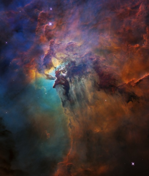
The Lagoon Nebula
This colorful image, taken by our Hubble Space Telescope between Feb. 12 and Feb. 18, 2018 , celebrated the Earth-orbiting observatory’s 28th anniversary of viewing the heavens, giving us a window seat to the universe’s extraordinary tapestry of stellar birth and destruction.
At the center of the photo, a monster young star 200,000 times brighter than our Sun is blasting powerful ultraviolet radiation and hurricane-like stellar winds, carving out a fantasy landscape of ridges, cavities, and mountains of gas and dust.
This region epitomizes a typical, raucous stellar nursery full of birth and destruction. The clouds may look majestic and peaceful, but they are in a constant state of flux from the star’s torrent of searing radiation and high-speed particles from stellar winds. As the monster star throws off its natal cocoon of material with its powerful energy, it is suppressing star formation around it.
Make sure to follow us on Tumblr for your regular dose of space: http://nasa.tumblr.com.
Top 10 Things to Know for the Return of our Launch America Mission With SpaceX

History was made May 30 when NASA astronauts Robert Behnken and Douglas Hurley launched from American soil in a commercially built and operated American crew spacecraft on its way to the International Space Station.
Pictured above is the SpaceX Dragon Endeavour spacecraft that lifted off on the company’s Falcon 9 rocket from Launch Complex 39A at Kennedy Space Center in Florida and docked with the space station on May 31. Now, Behnken and Hurley are ready to return home in Endeavour for a splashdown off the coast of Florida, closing out a mission designed to test SpaceX’s human spaceflight system, including launch, docking, splashdown, and recovery operations. Undocking is targeted for 7:34 p.m. ET on August 1, with splashdown back to Earth slated for 2:42 p.m. on August 2. Watch our continuous live coverage HERE.
1. Where will Behnken and Hurley splash down?

Image: SpaceX’s Crew Dragon is guided by four parachutes as it splashes down in the Atlantic on March 8, 2019, after the uncrewed spacecraft's return from the International Space Station on the Demo-1 mission.
Together with SpaceX, we are capable of supporting seven splashdown sites off the coast of Florida. The seven potential splashdown sites for the Dragon Endeavor are off the coasts of Pensacola, Tampa, Tallahassee, Panama City, Cape Canaveral, Daytona, and Jacksonville.
2. How will a splashdown location be chosen?
Splashdown locations are selected using defined priorities, starting with selecting a station departure date and time with the maximum number of return opportunities in geographically diverse locations to protect for weather changes. Teams also prioritize locations which require the shortest amount of time between undocking and splashdown based on orbital mechanics, and splashdown opportunities that occur in daylight hours.
Check out the Departure and Splashdown Criteria Fact Sheet for an in-depth look at selecting return locations, decision points during return, and detailed weather criteria.
3. How long will it take for Behnken and Hurley to return to Earth?

Return time for Behnken and Hurley will vary depending on the undock and splashdown opportunities chosen, with the primary opportunity taking between six and 30 hours.
4. What does the return look like? What are the major milestones?

Crew Dragon’s return home will start with undocking from the International Space Station. At the time of undock, Dragon Endeavour and its trunk weigh approximately 27,600 pounds. We will provide live coverage of the return from undocking all the way through splashdown.
There will be two very small engine burns immediately after hooks holding Crew Dragon in place retract to actually separate the spacecraft from the station. Once flying free, Dragon Endeavour will autonomously execute four departure burns to move the spaceship away from the space station and begin the flight home. Several hours later, one departure phasing burn, lasting about six minutes, puts Crew Dragon on the proper orbital path to line it up with the splashdown zone.
Shortly before the final deorbit burn, Crew Dragon will separate from its trunk, which will burn up in Earth’s atmosphere. The spacecraft then executes the deorbit burn, which commits Crew Dragon to return and places it on an orbit with the proper trajectory for splashdown. After trunk separation and the deorbit burn are complete, the Crew Dragon capsule weighs approximately 21,200 pounds.
5. How fast will Dragon Endeavour be going when it re-enters the Earth’s atmosphere? How hot will it get?
Crew Dragon will be traveling at orbital velocity prior to re-entry, moving at approximately 17,500 miles per hour. The maximum temperature it will experience on re-entry is approximately 3,500 degrees Fahrenheit. The re-entry creates a communications blackout between the spacecraft and Earth that is expected to last approximately six minutes.
6. When do the parachutes deploy?

Image: SpaceX’s final test of Crew Dragon’s Mark 3 parachute system on Friday, May 1, 2020, that will be used during the Demo-2 splashdwon mission.
Dragon Endeavour has two sets of parachutes will that deploy once back inside Earth’s atmosphere to slow down prior to splashdown. Two drogue parachutes will deploy at about 18,000 feet in altitude while Crew Dragon is moving approximately 350 miles per hour. Four main parachutes will deploy at about 6,000 feet in altitude while Crew Dragon is moving approximately 119 miles per hour.
7. Who recovers the crew and the Dragon Endeavour capsule from the water? What vehicles and personnel are involved?

Image: SpaceX’s Crew Dragon is loaded onto the company’s recovery ship, Go Searcher, in the Atlantic Ocean, about 200 miles off Florida’s east coast, on March 8, after returning from the International Space Station on the Demo-1 mission.Credits: SpaceX
For splashdown at any of the seven potential sites, SpaceX personnel will be on location to recover the capsule from the water. Two recovery ships, the Go Searcher and the Go Navigator, split locations between the Gulf of Mexico and the Atlantic Ocean off the coast of Florida. On either ship will be more than 40 personnel from SpaceX and NASA, made up of spacecraft engineers, trained water recovery experts, medical professionals, the ship’s crew, NASA cargo experts, and others to assist in the recovery.
8. How long after splashdown until Behnken and Hurley are out of the capsule?

Image: NASA astronaut Doug Hurley, along with teams from NASA and SpaceX, rehearse crew extraction from SpaceX’s Crew Dragon, on August 13, 2019. Credits: NASA/Bill Ingalls
Immediately after splashdown has occurred, two fast boats with SpaceX personnel deploy from the main recovery ship. The first boat checks capsule integrity and tests the area around the Crew Dragon for the presence of any hypergolic propellant vapors. Once cleared, the personnel on the boats begin preparing the spaceship for recovery by the ship. The second fast boat is responsible for safing and recovering Crew Dragon’s parachutes, which have at this point detached from the capsule and are in the water.
At this point the main recovery vessel can move in and begin to hoist the Crew Dragon capsule onto the main deck. Once the capsule is on the recovery vessel, it is moved to a stable location for the hatch to be opened for waiting medical professionals to conduct initial checks and assist Behnken and Hurley out of Dragon Endeavour.
This entire process is expected to take approximately 45 to 60 minutes, depending on spacecraft and sea state conditions.
9. Where do Behnken and Hurley go after they are out of the capsule?
Immediately after exiting the Crew Dragon capsule, Behnken and Hurley will be assisted into a medical area on the recovery ship for initial assessment. This is similar to procedures when welcoming long-duration crew members returning home on Soyuz in Kazakhstan.
After initial medical checks, Behnken and Hurley will be returned to shore either by traveling on the primary recovery ship or by helicopter. Helicopter returns from the recovery ship are the baseline for all splashdown zones except for the Cape Canaveral splashdown site, with travel times ranging from approximately 10 minutes to 80 minutes. The distance from shore will be variable depending on the splashdown location, ranging from approximately 22 nautical miles to 175 nautical miles.
Once returned to shore, both crew members will immediately board a waiting NASA plane to fly back to Ellington field in Houston.
10. What happens next?

Image: NASA astronauts Shannon Walker, Victor Glover Jr. and Mike Hopkins and Japan’s Soichi Noguchi train in a SpaceX Crew Dragon capsule. Credit: SpaceX
Meanwhile, Dragon Endeavour will be returned back to the SpaceX Dragon Lair in Florida for inspection and processing. Teams will examine the data and performance of the spacecraft throughout the test flight to complete the certification of the system to fly operational missions for our Commercial Crew and International Space Station Programs. The certification process is expected to take about six weeks. Following successful certification, the first operational mission will launch with Crew Dragon commander Michael Hopkins, pilot Victor Glover, and mission specialist Shannon Walker – all of NASA – along with Japan Aerospace Exploration Agency (JAXA) mission specialist Soichi Noguchi will launch on the Crew-1 mission from Launch Complex 39A at NASA’s Kennedy Space Center in Florida. The four crew members will spend six months on the space station.
The launch is targeted for no earlier than late-September.
Make sure to follow us on Tumblr for your regular dose of space: http://nasa.tumblr.com
New Research Heading to Earth’s Orbiting Laboratory
It’s a bird! It’s a plane! It’s a…dragon? A SpaceX Dragon spacecraft is set to launch into orbit atop the Falcon 9 rocket toward the International Space Station for its 12th commercial resupply (CRS-12) mission August 14 from our Kennedy Space Center in Florida.

It won’t breathe fire, but it will carry science that studies cosmic rays, protein crystal growth, bioengineered lung tissue.

Here are some highlights of research that will be delivered:
I scream, you scream, we all scream for ISS-CREAM!
Cosmic Rays, Energetics and Mass, that is! Cosmic rays reach Earth from far outside the solar system with energies well beyond what man-made accelerators can achieve. The Cosmic Ray Energetics and Mass (ISS-CREAM) instrument measures the charges of cosmic rays ranging from hydrogen to iron nuclei. Cosmic rays are pieces of atoms that move through space at nearly the speed of light

The data collected from the instrument will help address fundamental science questions such as:
Do supernovae supply the bulk of cosmic rays?
What is the history of cosmic rays in the galaxy?
Can the energy spectra of cosmic rays result from a single mechanism?
ISS-CREAM’s three-year mission will help the scientific community to build a stronger understanding of the fundamental structure of the universe.
Space-grown crystals aid in understanding of Parkinson’s disease
The microgravity environment of the space station allows protein crystals to grow larger and in more perfect shapes than earth-grown crystals, allowing them to be better analyzed on Earth.

Developed by the Michael J. Fox Foundation, Anatrace and Com-Pac International, the Crystallization of Leucine-rich repeat kinase 2 (LRRK2) under Microgravity Conditions (CASIS PCG 7) investigation will utilize the orbiting laboratory’s microgravity environment to grow larger versions of this important protein, implicated in Parkinson’s disease.

Defining the exact shape and morphology of LRRK2 would help scientists to better understand the pathology of Parkinson’s and could aid in the development of therapies against this target.
Mice Help Us Keep an Eye on Long-term Health Impacts of Spaceflight
Our eyes have a whole network of blood vessels, like the ones in the image below, in the retina—the back part of the eye that transforms light into information for your brain. We are sending mice to the space station (RR-9) to study how the fluids that move through these vessels shift their flow in microgravity, which can lead to impaired vision in astronauts.

By looking at how spaceflight affects not only the eyes, but other parts of the body such as joints, like hips and knees, in mice over a short period of time, we can develop countermeasures to protect astronauts over longer periods of space exploration, and help humans with visual impairments or arthritis on Earth.
Telescope-hosting nanosatellite tests new concept
The Kestrel Eye (NanoRacks-KE IIM) investigation is a microsatellite carrying an optical imaging system payload, including an off-the-shelf telescope. This investigation validates the concept of using microsatellites in low-Earth orbit to support critical operations, such as providing lower-cost Earth imagery in time-sensitive situations, such as tracking severe weather and detecting natural disasters.

Sponsored by the ISS National Laboratory, the overall mission goal for this investigation is to demonstrate that small satellites are viable platforms for providing critical path support to operations and hosting advanced payloads.
Growth of lung tissue in space could provide information about diseases
The Effect of Microgravity on Stem Cell Mediated Recellularization (Lung Tissue) uses the microgravity environment of space to test strategies for growing new lung tissue. The cells are grown in a specialized framework that supplies them with critical growth factors so that scientists can observe how gravity affects growth and specialization as cells become new lung tissue.

The goal of this investigation is to produce bioengineered human lung tissue that can be used as a predictive model of human responses allowing for the study of lung development, lung physiology or disease pathology.
These crazy-cool investigations and others launching aboard the next SpaceX #Dragon cargo spacecraft on August 14. They will join many other investigations currently happening aboard the space station. Follow @ISS_Research on Twitter for more information about the science happening on 250 miles above Earth on the space station.
Watch the launch live HERE starting at 12:20 p.m. EDT on Monday, Aug. 14!
Make sure to follow us on Tumblr for your regular dose of space: http://nasa.tumblr.com
Using a fleet of research aircraft, our Operation IceBridge images Earth's polar ice to better understand connections between polar regions and the global climate system. IceBridge studies annual changes in thickness of sea ice, glaciers and ice sheets. IceBridge bridges the gap between the ICESat missions.
Seen here is a time-lapse view of a glacier-run from the cockpit of our P-3 Orion aircraft taken during a May 8, 2017 flight over Greenland's Southeast glaciers.
Video credit: NASA/Gerrit Everson
Take a look back at this season’s Arctic ice survey HERE.
Make sure to follow us on Tumblr for your regular dose of space: http://nasa.tumblr.com
The 2017 Atlantic Hurricane Season: What We Learned

The 2017 Atlantic hurricane season was among the top ten most active seasons in recorded history. Our experts are exploring what made this year particularly active and the science behind some of the biggest storms to date.

After a period of 12 years without a Category 3 or higher hurricane making landfall in the U.S., Hurricane Harvey made landfall over Texas as a Category 4 hurricane this August.
Harvey was also the biggest rainfall event ever to hit the continental U.S. with estimates more than 49 inches of rain.

Data like this from our Global Precipitation Measurement Mission, which shows the amount of rainfall from the storm and temperatures within the story, are helping scientists better understand how storms develop.

The unique vantage point of satellites can also help first responders, and this year satellite data helped organizations map out response strategies during hurricanes Harvey, Irma and Maria.

In addition to satellites, we use ground stations and aircraft to track hurricanes.

We also use the capabilities of satellites like Suomi NPP and others that are able to take nighttime views. In this instance, we were able to view the power outages in Puerto Rico. This allowed first responders to see where the location of impacted urban areas.

The combined effort between us, NOAA, FEMA and other federal agencies helps us understand more about how major storms develop, how they gain strength and how they affect us.

To learn more about how we study storms, go to www.nasa.gov/Hurricanes.
Make sure to follow us on Tumblr for your regular dose of space: http://nasa.tumblr.com.
@barnabasthebarmy: How do you deal with being cooped up with other people for so long?
-
 watch reblogged this · 1 year ago
 -
 justatheatrekidwholovesspace liked this · 4 years ago
 -
 unknown-uwoit liked this · 5 years ago
 -
 mybendystraw liked this · 5 years ago
 -
 eirstohter liked this · 5 years ago
 -
 nasatranscription reblogged this · 5 years ago
 -
 skcirthinq reblogged this · 5 years ago
 -
 insertanonymousname liked this · 5 years ago
 -
 qweenofghosts liked this · 5 years ago
 -
 lennoxs liked this · 5 years ago
 -
 lucmarcou liked this · 5 years ago
 -
 bi-streetcat liked this · 5 years ago
 -
 passionatedisdain liked this · 5 years ago
 -
 fellowitch liked this · 5 years ago
 -
 riffsphere-blog liked this · 5 years ago
 -
 delicatemusictale liked this · 5 years ago
 -
 malecus liked this · 5 years ago
 -
 gautrau liked this · 5 years ago
 -
 angelglick reblogged this · 5 years ago
 -
 chocolateismynemesis reblogged this · 5 years ago
 -
 rosaliachristian liked this · 5 years ago
 -
 roadtripjb406 liked this · 5 years ago
 -
 marsbartobobbity liked this · 5 years ago
 -
 itarilde-elentari reblogged this · 5 years ago
 -
itarilde-elentari liked this · 5 years ago
-
 muhbeans liked this · 5 years ago
 -
 lesbiangummybearmafia liked this · 5 years ago
 -
 realspaceships liked this · 5 years ago
 -
choicesstanblog liked this · 5 years ago
-
 imwangimwang liked this · 5 years ago
 -
 to-worlds-more-beautiful liked this · 5 years ago
 -
 eldritchmage liked this · 5 years ago
 -
maggietann reblogged this · 5 years ago
-
maggietann liked this · 5 years ago
-
 themarionettewashere liked this · 5 years ago
 -
 humongoushorseoperasuitcase liked this · 5 years ago
 -
 maudlinsolus liked this · 5 years ago
 -
 fyrefyrefromtheskyy liked this · 5 years ago
 -
 youhaveafriend-in-sennin liked this · 5 years ago
 -
dap959799 liked this · 5 years ago
-
 axellvcero reblogged this · 5 years ago
 -
axellvcero liked this · 5 years ago
-
 weird-is-all-ive-got reblogged this · 5 years ago
Explore the universe and discover our home planet with the official NASA Tumblr account
1K posts