Do You Believe In Magic? ✨ While Appearing As A Delicate And Light Veil Draped Across The Sky,
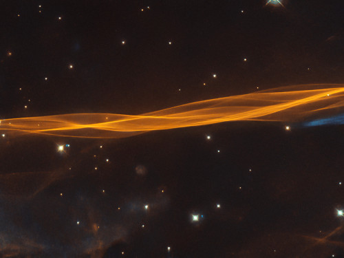
Do you believe in magic? ✨ While appearing as a delicate and light veil draped across the sky, this @NASAHubble image reminds us of the power of imagination. What does this look like to you? In reality, it's a small section of a Cygnus supernova blast wave, located around 2,400 light-years away. The original supernova explosion blasted apart a dying star about 20 times more massive than our Sun between 10,000 and 20,000 years ago. Since then, the remnant has expanded 60 light-years from its center. Credit: @ESA/Hubble & NASA, W. Blair; acknowledgment: Leo Shatz
More Posts from Nasa and Others
We’re Landing a Rover on Mars in 2020…But How Do We Decide Where?
In 2020, we will launch our next Mars rover. It will journey more than 33 million miles to the Red Planet where it will land, explore and search for signs of ancient microbial life. But how do we pinpoint the perfect location to complete this science…when we’re a million miles away on Earth?

We utilize data sent to us by spacecraft on and orbiting Mars. That includes spacecraft that have recorded data in the past.
This week, hundreds of scientists and Mars enthusiasts are gathering to deliberate the four remaining options for where we’re going to land the Mars 2020 rover on the Red Planet.

The landing site for Mars 2020 is of great interest to the planetary community because, among the rover's new science gear for surface exploration, it carries a sample system that will collect rock and soil samples and set them aside in a "cache" on the surface of Mars. A future mission could potentially return these samples to Earth. The next Mars landing, after Mars 2020, could very well be a vehicle which would retrieve these Mars 2020 samples.
Here's an overview of the potential landing sites for our Mars 2020 rover…
Northeast Syrtis

This area was once warmed by volcanic activity. Underground heat sources made hot springs flow and surface ice melt. Microbes could have flourished here in liquid water that was in contact with minerals. The layered terrain there holds a rich record of interactions between water and minerals over successive periods of early Mars history.
Jezero Crater

This area tells a story of the on-again, off-again nature of the wet past of Mars. Water filled and drained away from the crater on at least two occasions. More than 3.5 billion years ago, river channels spilled over the crater wall and created a lake. Scientists see evidence that water carried clay minerals from the surrounding area into the crater after the lake dried up. Conceivably, microbial life could have lived in Jezero during one or more of these wet times. If so, signs of their remains might be found in lakebed sediments.
Columbia Hills

At this site, mineral springs once bubbled up from the rocks. The discovery that hot springs flowed here was a major achievement of the Mars Exploration Rover, Spirit. The rover’s discovery was an especially welcome surprise because Spirit had not found signs of water anywhere else in the 100-mile-wide Gusev Crater. After the rover stopped working in 2010, studies of its older data records showed evidence that past floods may have formed a shallow lake in Gusev.
Midway

Candidate landing sites Jezero and Northeast Syrtis are approximately 37 km apart…which is close enough for regional geologic similarities to be present, but probably too far for the Mars 2020 rover to travel. This midway point allows exploration of areas of both landing sites.

How Will We Select a Site?
The team is gathered this week for the fourth time to discuss these locations. It'll be the final workshop in a series designed to ensure we receive the best and most diverse range of information and opinion from the scientific community before deciding where to send our newest rover.
The Mars 2020 mission is tasked with not only seeking signs of ancient habitable conditions on Mars, but also searching for signs of past microbial life itself. So how do we choose a landing site that will optimize these goals? Since InSight is stationary and needs a flat surface to deploy its instruments, we’re basically looking for a flat, parking lot area on Mars to land the spacecraft.

The first workshop started with about 30 candidate landing sites and was narrowed down to eight locations to evaluate further. At the end of the third workshop in February 2017, there were only three sites on the radar as potential landing locations…
…but in the ensuing months, a proposal came forward for a landing site that is in between Jezero and Northeast Syrtis – The Midway site. Since our goal is to get to the right site that provides the maximum science, this fourth site was viewed as worthy of being included in the discussions.
Now, with four sites remaining, champions for each option will take their turn at the podium, presenting and defending their favorite spot on the Red Planet.

On the final day, after all presentations have concluded, workshop participants will weigh the pros and cons of each site. The results of these deliberations will be provided to the Mars 2020 Team, which will incorporate them into a recommendation to NASA Headquarters. A final selection will be made and will likely be announced by the end of the year.
To get more information about the workshop, visit: https://marsnext.jpl.nasa.gov/workshops/wkshp_2018_10.cfm
Learn more about our Mars 2020 rover HERE.
Make sure to follow us on Tumblr for your regular dose of space: http://nasa.tumblr.com.
Solar System: 10 Things to Know This Week
The Living Planet Edition
Whether it's crops, forests or phytoplankton blooms in the ocean, our scientists are tracking life on Earth. Just as satellites help researchers study the atmosphere, rainfall and other physical characteristics of the planet, the ever-improving view from above allows them to study Earth's interconnected life.
1. Life on Earth, From Space

While we (NASA) began monitoring life on land in the 1970s with the Landsat satellites, this fall marks 20 years since we've continuously observed all the plant life at the surface of both the land and ocean. The above animation captures the entirety of two decades of observations.
2. Watching the World Breathe
With the right tools, we can see Earth breathe. With early weather satellite data in the 1970s and '80s, NASA Goddard scientist Compton Tucker was able to see plants' greening and die-back from space. He developed a way of comparing satellite data in two wavelengths.

When healthy plants are stocked with chlorophyll and ready to photosynthesize to make food (and absorb carbon dioxide), leaves absorb red light but reflect infrared light back into space. By comparing the ratio of red to infrared light, Tucker and his colleagues could quantify vegetation covering the land.
Expanding the study to the rest of the globe, the scientists could track rainy and dry seasons in Africa, see the springtime blooms in North America, and wildfires scorching forests worldwide.
3. Like Breathing? Thank Earth's Ocean

But land is only part of the story. The ocean is home to 95 percent of Earth's living space, covering 70 percent of the planet and stretching miles deep. At the base of the ocean's food web is phytoplankton - tiny plants that also undergo photosynthesis to turn nutrients and carbon dioxide into sugar and oxygen. Phytoplankton not only feed the rest of ocean life, they absorb carbon dioxide - and produce about half the oxygen we breathe.

In the Arctic Ocean, an explosion of phytoplankton indicates change. As seasonal sea ice melts, warming waters and more sunlight will trigger a sudden, massive phytoplankton bloom that feeds birds, sea lions and newly-hatched fish. But with warming atmospheric temperatures, that bloom is now happening several weeks earlier - before the animals are in place to take advantage of it.
4. Keeping an Eye on Crops
The "greenness" measurement that scientists use to measure forests and grasslands can also be used to monitor the health of agricultural fields. By the 1980s, food security analysts were approaching NASA to see how satellite images could help with the Famine Early Warning System to identify regions at risk - a partnership that continues today.

With rainfall estimates, vegetation measurements, as well as the recent addition of soil moisture information, our scientists can help organizations like USAID direct emergency help.
The view from space can also help improve agricultural practices. A winery in California, for example, uses individual pixels of Landsat data to determine when to irrigate and how much water to use.
5. Coming Soon to the International Space Station

A laser-based instrument being developed for the International Space Station will provide a unique 3-D view of Earth's forests. The instrument, called GEDI, will be the first to systematically probe the depths of the forests from space.

Another ISS instrument in development, ECOSTRESS, will study how effectively plants use water. That knowledge provided on a global scale from space will tell us "which plants are going to live or die in a future world of greater droughts," said Josh Fisher, a research scientist at NASA's Jet Propulsion Laboratory and science lead for ECOSTRESS.
6. Seeing Life, From the Microscopic to Multicellular
Scientists have used our vantage from space to study changes in animal habitats, track disease outbreaks, monitor forests and even help discover a new species. Bacteria, plants, land animals, sea creatures and birds reveal a changing world.

Our Black Marble image provides a unique view of human activity. Looking at trends in our lights at night, scientists can study how cities develop over time, how lighting and activity changes during certain seasons and holidays, and even aid emergency responders during power outages caused by natural disasters.
7. Earth as Analog and Proving Ground
Just as our Mars rovers were tested in Earth's deserts, the search for life on ocean moons in our solar system is being refined by experiments here. JPL research scientist Morgan Cable looks for life on the moons of Jupiter and Saturn. She cites satellite observations of Arctic and Antarctic ice fields that are informing the planning for a future mission to Europa, an icy moon of Jupiter.

The Earth observations help researchers find ways to date the origin of jumbled, chaotic ice. "When we visit Europa, we want to go to very young places, where material from that ocean is being expressed on the surface," she explained. "Anywhere like that, the chances of finding biomarkers goes up - if they're there."
8. Only One Living Planet
Today, we know of only one living planet: our own. The knowledge and tools NASA developed to study life here are among our greatest assets as we begin the search for life beyond Earth.

There are two main questions: With so many places to look, how can we home in on the places most likely to harbor life? What are the unmistakable signs of life - even if it comes in a form we don't fully understand? In this early phase of the search, "We have to go with the only kind of life we know," said Tony del Genio, co-lead of a new NASA interdisciplinary initiative to search for life on other worlds.

So, the focus is on liquid water. Even bacteria around deep-sea vents that don't need sunlight to live need water. That one necessity rules out many planets that are too close or too far from their stars for water to exist, or too far from us to tell. Our Galileo and Cassini missions revealed that some moons of Jupiter and Saturn are not the dead rocks astronomers had assumed, but appear to have some conditions needed for life beneath icy surfaces.
9. Looking for Life Beyond Our Solar System
In the exoplanet (planets outside our solar system that orbit another star) world, it's possible to calculate the range of distances for any star where orbiting planets could have liquid water. This is called the star's habitable zone. Astronomers have already located some habitable-zone planets, and research scientist Andrew Rushby of NASA Ames Research Center is researching ways to refine the search. "An alien would spot three planets in our solar system in the habitable zone [Earth, Mars and Venus]," Rushby said, "but we know that 67 percent of those planets are not inhabited."

He recently developed a model of Earth's carbon cycle and combined it with other tools to study which planets in habitable zones would be the best targets to look for life, considering probable tectonic activity and water cycles. He found that larger planets are more likely than smaller ones to have surface temperatures conducive to liquid water. Other exoplanet researchers are looking for rocky worlds, and biosignatures, the chemical signs of life.
10. You Can Learn a Lot from a Dot
When humans start collecting direct images of exoplanets, even the closest ones will appear as only a handful of pixels in the detector - something like the famous "blue dot" image of Earth from Saturn. What can we learn about life on these planets from a single dot?

Stephen Kane of the University of California, Riverside, has come up with a way to answer that question by using our EPIC camera on NOAA's DSCOVR satellite. "I'm taking these glorious pictures and collapsing them down to a single pixel or handful of pixels," Kane explained. He runs the light through a noise filter that attempts to simulate the interference expected from an exoplanet mission. By observing how the brightness of Earth changes when mostly land is in view compared with mostly water, Kane reverse-engineers Earth's rotation rate - something that has yet to be measured directly for exoplanets.
The most universal, most profound question about any unknown world is whether it harbors life. The quest to find life beyond Earth is just beginning, but it will be informed by the study of our own living planet.
Make sure to follow us on Tumblr for your regular dose of space: http://nasa.tumblr.com.
Not a question, but I just want to say that today is my daughter Erin's 7th birthday and she's wearing her NASA shirt and I want to thank you so much for being such an amazing inspiration to my daughter, myself, and women and girls everywhere. <3
Adorable! Please continue to encourage her to reach for the stars.
how can one work in nasa? it's my dream to work in nasa someday, right now, I'm just a high schooler but I've been planning out my trajectory so some advice and tips would be helpful.
Ever get a random craving for a food when in space?
Did you recently hear that NASA changed the zodiac signs? Nope, we definitely didn’t…
Constellations and the Calendar
Did you recently hear that NASA changed the zodiac signs? Nope, we definitely didn’t…
…Here at NASA, we study astronomy, not astrology. We didn’t change any zodiac signs, we just did the math. Here are the details:
First Things First: Astrology is not Astronomy…
Astronomy is the scientific study of everything in outer space. Astronomers and other scientists know that stars many light-years away have no effect on the ordinary activities of humans on Earth.
Astrology, meanwhile, is something else. It’s the belief that the positions of stars and planets can influence human events. It’s not considered a science.

Some curious symbols ring the outside of the Star Finder. These symbols stand for some of the constellations in the zodiac. What is the zodiac and what is special about these constellations?

Imagine a straight line drawn from Earth though the sun and out into space way beyond our solar system where the stars are. Then, picture Earth following its orbit around the sun. This imaginary line would rotate, pointing to different stars throughout one complete trip around the sun – or, one year. All the stars that lie close to the imaginary flat disk swept out by this imaginary line are said to be in the zodiac.

The constellations in the zodiac are simply the constellations that this imaginary straight line points to in its year-long journey.
What are Constellations?
A constellation is group of stars like a dot-to-dot puzzle. If you join the dots—stars, that is—and use lots of imagination, the picture would look like an object, animal, or person. For example, Orion is a group of stars that the Greeks thought looked like a giant hunter with a sword attached to his belt. Other than making a pattern in Earth’s sky, these stars may not be related at all.

Even the closest star is almost unimaginably far away. Because they are so far away, the shapes and positions of the constellations in Earth’s sky change very, very slowly. During one human lifetime, they change hardly at all.
A Long History of Looking to the Stars
The Babylonians lived over 3,000 years ago. They divided the zodiac into 12 equal parts – like cutting a pizza into 12 equal slices. They picked 12 constellations in the zodiac, one for each of the 12 “slices.” So, as Earth orbits the sun, the sun would appear to pass through each of the 12 parts of the zodiac. Since the Babylonians already had a 12-month calendar (based on the phases of the moon), each month got a slice of the zodiac all to itself.

But even according to the Babylonians’ own ancient stories, there were 13 constellations in the zodiac. So they picked one, Ophiuchus, to leave out. Even then, some of the chosen 12 didn’t fit neatly into their assigned slice of the pie and crossed over into the next one.

When the Babylonians first invented the 12 signs of zodiac, a birthday between about July 23 and August 22 meant being born under the constellation Leo. Now, 3,000 years later, the sky has shifted because Earth’s axis (North Pole) doesn’t point in quite the same direction.

The constellations are different sizes and shapes, so the sun spends different lengths of time lined up with each one. The line from Earth through the sun points to Virgo for 45 days, but it points to Scorpius for only 7 days. To make a tidy match with their 12-month calendar, the Babylonians ignored the fact that the sun actually moves through 13 constellations, not 12. Then they assigned each of those 12 constellations equal amounts of time.
So, we didn’t change any zodiac signs…we just did the math.
Make sure to follow us on Tumblr for your regular dose of space: http://nasa.tumblr.com
A Year on the Sun Through Our Satellite’s Eyes
Did you know we’re watching the Sun 24/7 from space?
We use a whole fleet of satellites to monitor the Sun and its influences on the solar system. One of those is the Solar Dynamics Observatory. It’s been in space for eight years, keeping an eye on the Sun almost every moment of every day. Launched on Feb. 11, 2010, this satellite (also known as SDO) was originally designed for a two-year mission, but it’s still collecting data to this day — and one of our best ways to keep an eye on our star.
To celebrate another year of SDO, we’re sharing some of our favorite solar views that the spacecraft sent back to Earth in 2017.
March: A long spotless stretch

For 15 days starting on March 7, SDO saw the yolk-like spotless Sun in visible light.
The Sun goes through a natural 11-year cycle of activity marked by two extremes: solar maximum and solar minimum. Sunspots are dark regions of complex magnetic activity on the Sun’s surface, and the number of sunspots at any given time is used as an index of solar activity.
Solar maximum = intense solar activity and more sunspots
Solar minimum = less solar activity and fewer sunspots
This March 2017 period was the longest stretch of spotlessness since the last solar minimum in April 2010 – a sure sign that the solar cycle is marching on toward the next minimum, which scientists expect in 2019-2020. For comparison, the images on the left are from Feb. 2014 – during the last solar maximum – and show a much spottier Sun.
June: Energized active regions

A pair of relatively small but frenetic active regions – areas of intense and complex magnetic fields – rotated into SDO’s view May 31 – June 2, while spouting off numerous small flares and sweeping loops of plasma. The dynamic regions were easily the most remarkable areas on the Sun during this 42-hour period.
July: Two weeks in the life of a sunspot
On July 5, SDO watched an active region rotate into view on the Sun. The satellite continued to track the region as it grew and eventually rotated across the Sun and out of view on July 17.
With their complex magnetic fields, sunspots are often the source of interesting solar activity: During its 13-day trip across the face of the Sun, the active region — dubbed AR12665 — put on a show for our Sun-watching satellites, producing several solar flares, a coronal mass ejection and a solar energetic particle event.
August: An eclipse in space

While millions of people in North America experienced a total solar eclipse on Aug. 21, SDO saw a partial eclipse from space. SDO actually sees several lunar transits a year from its perspective – but an eclipse on the ground doesn’t necessarily mean that SDO will see anything out of the ordinary. Even on Aug. 21, SDO saw only 14 percent of the Sun blocked by the Moon, while most US residents saw 60 percent blockage or more.
September: A spate of solar activity

In September 2017, SDO saw a spate of solar activity, with the Sun emitting 31 notable flares and releasing several powerful coronal mass ejections between Sept. 6-10. Solar flares are powerful bursts of radiation, while coronal mass ejections are massive clouds of solar material and magnetic fields that erupt from the Sun at incredible speeds.
One of the flares imaged by SDO on Sept. 6 was classified as X9.3 – clocking in at the most powerful flare of the current solar cycle. The current cycle began in December 2008 and is now decreasing in intensity, heading toward solar minimum. During solar minimum, such eruptions on the Sun are increasingly rare, but history has shown that they can nonetheless be intense.
September: A trio of tempests

Three distinct solar active regions with towering arches rotated into SDO’s view over a three-day period from Sept. 24-26. Charged particles spinning along the ever-changing magnetic field lines above the active regions trace out the magnetic field in extreme ultraviolet light, a type of light that is typically invisible to our eyes, but is colorized here in gold. To give some sense of scale, the largest arches are many times the size of Earth.
December: A curling prominence

SDO saw a small prominence arch up and send streams of solar material curling back into the Sun over a 30-hour period on Dec. 13-14. Prominences are relatively cool strands of solar material tethered above the Sun’s surface by magnetic fields.
December: Solar question mark

An elongated coronal hole — the darker area near the center of the Sun’s disk — looked something like a question mark when seen in extreme ultraviolet light by SDO on Dec. 21-22. Coronal holes are magnetically open areas on the Sun that allow high-speed solar wind to gush out into space. They appear as dark areas when seen in certain wavelengths of extreme ultraviolet light.
For all the latest on the Solar Dynamics Observatory, visit nasa.gov/sdo. Keep up with the latest on the Sun on Twitter @NASASun or at facebook.com/NASASunScience.
Make sure to follow us on Tumblr for your regular dose of space: http://nasa.tumblr.com
Vote for Space at SXSW 2017
We need your help! There are a number of exciting space-related panels proposed for next year’s South by Southwest Interactive Festival in Austin, Texas. SXSW is a community-driven event and voting accounts for 30% of the decision-making process for any given programming slot. The selection process is extremely competitive and the more votes we submit for the space panels, the more likely a panel related to space exploration will be included in the final SXSW program.

To help you out as you consider what to vote for, we’ve put together a list of all the NASA-related panel proposals.
These proposals look at ways we explore the solar system and beyond:
New Eyes on our Home System: NASA's Next Telescope
Dark Energy and Exoplanets: NASA's WFIRST Mission
Capturing NASA's James Webb Space Telescope
Lessons from the Fringes of the Solar System
Into the Unknown: The People Behind Webb Telescope
These proposals looks at how we’re using out-of-this-world tech and data to create incredible experiences here on Earth and helping solve challenges through your participation:
Space 360: Experience NASA Missions in VR/AR/video
The Power of Many: Wisdom from the Crowd
It’s Time to Ask More of Open Data
A little closer to home, this proposal explores our work to study and observe our dynamic home world, Earth:
NASA - Doing Work to Keep it Cool
We want to send humans on a journey to Mars. How? These proposals would dive into this question and more:
So you want to go to Mars?
Humans, Robots + Microbes: The Challenge of Mars
"Because They Are Hard": NASA & Mars
Lastly, we’re proposing a meetup for NASA and the entire space community at SXSW 2017:
Space Meetup
Community voting and commenting for SXSW 2017 is open through September 2, 2016.
We look forward to seeing you in Austin in March at the SXSW Interactive Festival. Thanks!
5 Space Software Codes We Can Use on Earth
We’ve made some amazingly advanced software for our space missions, from launching rockets to the International Space Station to landing rovers on Mars. But a lot of that software can be applied to other situations here on the ground. We’ve got hundreds of downloadable programs in the NASA Software Catalog available for public use—and they’re all free.
We’ve rounded up five interesting software programs to get your search started.
1. Take a walk on Mars from your living room
Want to walk around Mars from the comfort of your living room? OnSight can help with that. Our engineers and scientists created this mixed reality software to immerse themselves in a visualization of the terrain around the Curiosity rover, so users feel like they are really walking on the Red Planet. The software can be adapted to visualize other locations, which means it could also help us explore places on Earth, like caves and lava fields. No wonder it was awarded NASA’s 2018 Software of the Year!
2. Enhancing images from space and the doctor’s office

It’s hard to take a perfect picture from space. That’s why our scientists created the Hierarchical Image Segmentation software program – to help us enhance and analyze images taken of Earth from space by the Landsat and Terra missions. But, that isn’t all it can do. Doctors have used the software to analyze medical images, such as X-rays, ultrasounds and mammography images, to reveal important details previously unseen by the human eye.
3. Video game tech helps our engineers build spaceflight hardware

Installing sensitive spaceflight hardware is hardly a time for fun and games. Except when it comes to the Distributed Observer Network, or DON 3.1. This software combines innovative NASA tools with commercial video game technology to train our employees for stressful tasks – like maneuvering important, delicate tools through tight spots when building instruments or spacecraft. DON can be used in many other industries, particularly for overcoming the challenges that face virtual teams collaborating on complex problems.
4. Software helps protect Earth from space junk

Those of us on the ground may imagine space as a peaceful place to float among the stars, but in reality, Earth’s atmosphere is filled with junk. This space debris can cause damage to spacecraft and satellites, including the International Space Station. That’s where the Orbital Debris Engineering Model software program comes in. Thanks to this NASA software, we can study the risks of debris impact to help us protect our orbiting equipment and – more importantly – our planet. Communication companies could use this software to prevent debris damage when launching satellites, saving them a lot of time and money.
5. From exploration missions to your office, this software keeps projects on track

Do you manage complex projects at work? There are a lot of steps and moving pieces in play when it comes to getting a spacecraft from the launchpad into space. Used during the space shuttle missions, the Schedule Test and Assessment Tool 5.0 add-on works with Microsoft Project to automate project data to help us stay on track. It’s one of the more popular programs in our software catalog because it provides quick, clear assessment info that can help with decision making.
These are just a few examples of the software NASA has free and available for the public. To browse the new 2019-2020 catalog online, visit https://software.nasa.gov/.
Make sure to follow us on Tumblr for your regular dose of space: http://nasa.tumblr.com.
-
 nojkno liked this · 1 year ago
 -
 spensaweight77 liked this · 1 year ago
 -
 glenenelwethough liked this · 1 year ago
 -
 pedrummond reblogged this · 2 years ago
 -
 stardating reblogged this · 2 years ago
 -
 digitalbookofshawdows reblogged this · 3 years ago
 -
 nimbuscloudydazed reblogged this · 3 years ago
 -
 icewolf589 liked this · 3 years ago
 -
 xrxluvx1 liked this · 3 years ago
 -
 sunnythebunny2 liked this · 3 years ago
 -
 souless6 liked this · 3 years ago
 -
 coralladyfun liked this · 3 years ago
 -
 puffedwheatsquare liked this · 3 years ago
 -
 a-momentofsonder liked this · 3 years ago
Explore the universe and discover our home planet with the official NASA Tumblr account
1K posts