Hello!! Its Wonderful To Be Able To Ask Questions, Thank You!
Hello!! Its wonderful to be able to ask questions, thank you!
About Perseverance, does it have a self-repair option? And as Curiosity is still operational, will they run missions together? Or will they split up to cover more distance?
Is this a sign that we're close to being able to set foot on Mars?
My final question is how do you receive the messages from such a long distance?
Thanks for all your hard work! 加油/Good luck!
“Is this a sign that we are close to being able to set foot on Mars?”
More Posts from Nasa and Others
Our Planet: 8 Stunning Views of Earth from Space
Swirling clouds, deep blue oceans and textured land- and icescapes are among the many faces of our planet revealed in NASA’s new photo-essay book: Earth. This collection of 69 images captured by satellites tells a story of a 4.5-billion-year-old planet where there is always something new to see. Earth is a beautiful, awe-inspiring place, and it is the only world most of us will ever know. It is your planet. It is NASA’s mission. The book is available now in hardcover and ebook, and online with interactive features.
Here are eight of those breathtaking images for your viewing pleasure.
Channel Country, Australia

These wide floodplains in Queensland, Australia are unique on the planet. Scientists think they are caused by the extreme variation in water and sediment discharges from the rivers. In many years there is no rainfall at all, and the rivers are effectively non-existent. In years of modest rainfall, the main channels will carry some water, sometimes spilling over into narrow water holes known as billabongs.
Every few decades, the floodplain carries extremely high discharges of water. For instance, tropical storms to the north can lead to great water flows that inundate the entire width of the floodplain. On such occasions, the floodplain appears as series of brown and green water surfaces with only tree tops indicating the location of the islands. Such is the case in this image taken from the International Space Station in September 2016.
Grounded in the Caspian, Kazakhstan

A wide variety of ice forms in the Caspian Sea, which stretches from Kazakhstan to Iran. Just offshore, a well-developed expanse of consolidated ice appears bright white. Farther offshore, a gray-white field of chunky, hummocked ice has detached and is slowly drifting around a polynya, an area of open water surrounded by sea ice. That darker patch is actually growing young, thin ice and nilas, a term that designates sea ice crust up to 10 centimeters (4 inches) in thickness.
The close-up shows nilas and a white, diamond-shaped piece of ice. It might look like this chunk is on the move, cutting a path through thinner ice. But it’s more likely that the “diamond” was stuck to the sea bottom and the wind pushed ice around it.
Tsauchab River Bed, Namibia

The Tsauchab River is a famous landmark for the people of Namibia and tourists. Yet few people have ever seen the river flowing with water. In December 2009, an astronaut on the International Space Station caught this glimpse of the Tsauchab River bed jutting into the sea of red dunes. It ends in a series of light-colored, silty mud holes on the dry lake floor.
Like several other rivers around the Namib Desert, the Tsauchab brings sediment down from the hinterland toward the coastal lowland. This sediment is then blown from the river beds, and over tens of millions of years it has accumulated as the red dunes of the Namib Sand Sea.
Taranaki and Egmont, New Zealand

The circular pattern of New Zealand’s Egmont National Park stands out from space as a human fingerprint on the landscape. The park protects the forested and snow-capped slopes around Mount Taranaki (Mount Egmont to British settlers). It was established in 1900, when officials drew a radius of 10 kilometers around the volcanic peak. The colors differentiate the protected forest (dark green) from once-forested pasturelands (light- and brown-green).
Named by the native Maori people, Taranaki stands 2,518 meters (8,260 feet) tall, and it is one of the world’s most symmetric volcanoes. It first became active about 135,000 years ago. By dating lava flows, geologists have figured out that small eruptions occur roughly every 90 years and major eruptions every 500 years. Landsat 8 acquired this image of Taranaki and the park in July 2014.
Storms Stir Up Sediment in Bermuda

In October 2014, the eye of Hurricane Gonzalo passed right over Bermuda. In the process, the potent storm stirred up the sediments in the shallow bays and lagoons around the island, spreading a huge mass of sediment across the North Atlantic Ocean. This Landsat 8 image shows the area after Gonzalo passed through.
The suspended sediments were likely a combination of beach sand and carbonate sediments from around the shallows and reefs. Coral reefs can produce large amounts of calcium carbonate, which stays on the reef flats (where there are coralline algae that also produce carbonate) and builds up over time to form islands.
Framing an Iceberg in the South Atlantic Ocean

In June 2016, the Suomi NPP satellite captured this image of various cloud formations in the South Atlantic Ocean. Note how low stratus clouds framed a hole over iceberg A-56 as it drifted across the sea.
The exact reason for the hole in the clouds is somewhat of a mystery. It could have formed by chance, although imagery from the days before and after this date suggest something else was at work. It could be that the relatively unobstructed path of the clouds over the ocean surface was interrupted by thermal instability created by the iceberg. In other words, if an obstacle is big enough, it can divert the low-level atmospheric flow of air around it, a phenomenon often caused by islands.
Lofted Over Land in Madagascar

Along the muddy Mania River, midday clouds form over the forested land but not the water. In the tropical rainforests of Madagascar, there is ample moisture for cloud formation. Sunlight heats the land all day, warming that moist air and causing it to rise high into the atmosphere until it cools and condenses into water droplets. Clouds generally form where air is ascending (over land in this case), but not where it is descending (over the river). Landsat 8 acquired this image in January 2015.
A Lava Lamp Look at the Atlantic Ocean

Stretching from tropical Florida to the doorstep of Europe, the Gulf Stream carries a lot of heat, salt, and history. This river of water is an important part of the global ocean conveyor belt, moving water and heat from the Equator toward the far North Atlantic. It is one of the strongest currents on Earth and one of the most studied. Its discovery is often attributed to Benjamin Franklin, though sailors likely knew about the current long before they had a name for it.
This image shows a small portion of the Gulf Stream off of South Carolina as it appeared in infrared data collected by the Landsat 8 satellite in April 2013. Colors represent the energy—heat—being emitted by the water, with cooler temperatures in purple and the warmest water being nearly white. Note how the Gulf Stream is not a uniform band but instead has finer streams and pockets of warmer and colder water.
These images are just a few from our new book called Earth. Explore the other 61 images here.
Make sure to follow us on Tumblr for your regular dose of space: http://nasa.tumblr.com

Hi! The Sun is so bright I need shades... that are ISO 12312-2 compliant! So glad that you are all here and excited about the eclipse. I’m Alexa Halford and ready to answer your questions.
Mercury In the Spotlight
For more than seven hours on Monday, May 9, Mercury will be visible as a tiny black dot crossing the face of the sun. This rare event – which happens only slightly more than once a decade – is called a transit.

Although Mercury whips around the sun every 88 days – over four times faster than Earth – the three bodies rarely align. Because Mercury orbits in a plane 7 degrees tilted from Earth’s orbit, it usually darts above or below our line of sight to the sun. As a result, a Mercury transit happens only about 13 times a century. The last one was in 2006, and the next one isn’t until 2019.

When: On May 9, shortly after 7:00 a.m. EDT, Mercury will appear as a tiny black dot against a blazing backdrop, traversing the sun’s disk over seven and a half hours. Mercury will cross the edge of the sun (ingress) after 7:00 a.m. EDT. The mid-transit point will occur a little after 10:45 a.m. EDT, with egress around 2:30 p.m. EDT.
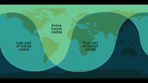
Where: Skywatchers in Western Europe, South America and eastern North America will be able to see the entirety of the transit. The entire 7.5-hour path across the sun will be visible across the Eastern U.S. – with magnification and proper solar filters – while those in the West can observe the transit in progress at sunrise.

Safety!
Unlike the 2012 Venus transit of the sun, Mercury is too small to be visible without magnification from a telescope or high-powered binoculars. Both must have safe solar filters made of specially-coated glass or Mylar; you can never look directly at the sun. We’re offering several avenues for the public to view the event without specialized and costly equipment, including images on NASA.gov, a one-hour NASA Television special, and social media coverage.

The Science…Why are Planetary Transits Important?
Transits like this allowed scientists in the 17th century to make the first estimates of Earth’s distance from the sun. Transit observations over the past few centuries have also helped scientists study everything from the atmosphere of Venus to the slight shifts in Mercury’s orbit that could only be explained by the theory of general relativity. Because we know Mercury’s size and location precisely, this transit will help scientists calibrate telescopes on solar observatories SDO, SOHO, and Hinode.

Transits can also teach us more about planets – both in and out of our solar system. The Venus transit in 2012 provided observations of the planet's atmosphere. Transits are also the main way we find planets outside the solar system, called exoplanets.

The transit method looks for a drop in the brightness of a star when a planet passes in front of it. This method will not find every planet – only those that happen to cross our line of sight from Earth to the star. But with enough sensitivity, the transit method through continuous monitoring is a great way to detect small, Earth-size planets, and has the advantage of giving us both the planet’s size (from the fraction of starlight blocked), as well as its orbit (from the period between transits). Our Kepler/K2 mission uses this method to find exoplanets, as will the Transiting Exoplanet Survey Satellites, or TESS, following its launch in 2017/2018.
We will stream a live program on NASA TV and the agency’s Facebook page from 10:30 to 11:30 a.m. -- an informal roundtable during which experts representing planetary, heliophysics and astrophysics will discuss the science behind the Mercury transit. Viewers can ask questions via Facebook and Twitter using #AskNASA.
Make sure to follow us on Tumblr for your regular dose of space: http://nasa.tumblr.com
Hunting for Organic Molecules on Mars

Did Mars once have life? To help answer that question, an international team of scientists created an incredibly powerful miniature chemistry laboratory, set to ride on the next Mars rover.

The instrument, called the Mars Organic Molecule Analyzer Mass Spectrometer (MOMA-MS), will form a key part of the ExoMars Rover, a joint mission between the European Space Agency (ESA) and Roscosmos. A mass spectrometer is crucial to send to Mars because it reveals the elements that can be found there. A Martian mass spectrometer takes a sample, typically of powdered rock, and distinguishes the different elements in the sample based on their mass.

After 8 years of designing, building, and testing, NASA scientists and engineers from NASA’s Goddard Space Flight Center said goodbye to their tiny chemistry lab and shipped it to Italy in a big pink box. Building a tiny instrument capable of conducting chemical analysis is difficult in any setting, but designing one that has to launch on a huge rocket, fly through the vacuum of space, and then operate on a planet with entirely different pressure and temperature systems? That’s herculean. And once on Mars, MOMA has a very important job to do. NASA Goddard Center Director Chris Scolese said, “This is the first intended life-detecting instrument that we have sent to Mars since Viking.”

The MOMA instrument will be capable of detecting a wide variety of organic molecules. Organic compounds are commonly associated with life, although they can be created by non-biological processes as well. Organic molecules contain carbon and hydrogen, and can include oxygen, nitrogen, and other elements.

To find these molecules on Mars, the MOMA team had to take instruments that would normally occupy a couple of workbenches in a chemistry lab and shrink them down to roughly the size of a toaster oven so they would be practical to install on a rover.

MOMA-MS, the mass spectrometer on the ExoMars rover, will build on the accomplishments from the Sample Analysis at Mars (SAM), an instrument suite on the Curiosity rover that includes a mass spectrometer. SAM collects and analyzes samples from just below the surface of Mars while ExoMars will be the first to explore deep beneath the surface, with a drill capable of taking samples from as deep as two meters (over six feet). This is important because Mars’s thin atmosphere and spotty magnetic field offer little protection from space radiation, which can gradually destroy organic molecules exposed on the surface. However, Martian sediment is an effective shield, and the team expects to find greater abundances of organic molecules in samples from beneath the surface.

On completion of the instrument, MOMA Project Scientist Will Brinckerhoff praised his colleagues, telling them, “You have had the right balance of skepticism, optimism, and ambition. Seeing this come together has made me want to do my best.”
In addition to the launch of the ESA and Roscosmos ExoMars Rover, in 2020, NASA plans to launch the Mars 2020 Rover, to search for signs of past microbial life. We are all looking forward to seeing what these two missions will find when they arrive on our neighboring planet.
Learn more about MOMA HERE.
Learn more about ExoMars HERE.
Follow @NASASolarSystem on Twitter for more about our missions to other planets.
Make sure to follow us on Tumblr for your regular dose of space: http://nasa.tumblr.com.
Six Things You Need to Know About the Green Propellant Infusion Mission
Next week, we’re launching a new “green” fuel to space for the first time! The Green Propellant Infusion Mission (GPIM)—which consists of a non-toxic liquid, compatible propulsion system and the small satellite it’s riding on—will demonstrate how our technology works so that future missions can take advantage of this safer, more efficient fuel alternative.

Here are six key facts to know about our Green Propellant Infusion Mission:
1) The Air Force Research Lab developed the “green” fuel.
The AFRL’s hydroxyl ammonium nitrate fuel/oxidizer blend—called AF-M315E—is actually peach in color. This liquid doesn’t require the kind of strict, handling protocols that conventional chemicals currently require. Think shirtsleeves instead of hazmat suits, which could reduce pre-launch ground processing time for a spacecraft from weeks to days!

Image Credit: Air Force Research Lab
2) It’s safer and more efficient.
The non-toxic fuel offers nearly 50% better performance when compared to today’s highly toxic chemical propellant, hydrazine. That’s equivalent to getting 50% more miles per gallon on your car. This means spacecraft can travel farther or operate for longer with less propellant in their fuel tanks.

3) The fuel can handle extreme temperatures.
Even on missions to extremely cold environments, such as the south pole of Mars – where temperatures can dip as low as -225 degrees Fahrenheit and carbon-dioxide ice “spiders” can form (see below) – AF-M315E won’t freeze, but rather just transforms into a glass transition phase. This means even though it turns into a solid, it won’t cause spacecraft components to stretch or expand, so the spacecraft only has to warm up the fuel when it needs it.

4) Industry is already lining up to use the technology.
Our commercial partners report that there is a lot of interest and potential for this tech. After we successfully prove how it works in space, small satellites to large spacecraft could benefit by using the green propellant system. It’d only be a matter of time before companies begin building the new systems for market.

5) GPIM required a team of talented engineers.
Engineers at Aerojet Rocketdyne in Redmond, Washington developed new, optimized hardware like thrusters, tanks, filters and valves to work with the green fuel. GPIM uses a set of thrusters that fire in different scenarios to test engine performance and reliability.

Ball Aerospace of Boulder, Colorado designed and built the mini fridge-sized spacecraft bus and pieced it all together.

Before being ready for flight, GPIM components went through rigorous testing at multiple NASA centers including our Glenn Research Center, Goddard Space Flight Center and Kennedy Space Center. The program team at Marshall Space Flight Center manages the mission. Once in orbit, researchers will work together to study how the fuel is performing as they manipulate the spacecraft. The demonstration mission will last about 13 months.
6) GPIM will hitch a ride on a SpaceX Falcon Heavy rocket.
SpaceX’s Falcon Heavy rocket will launch for a third time for the U.S. Department of Defense’s Space Test Program-2 (STP-2) mission targeted for June 24, 2019 at 11:30 p.m. EDT. With nearly two dozen other satellites from government, military and research institutions, GPIM will deploy within a few hours after launch from NASA’s Kennedy Space Center in Florida. The SpaceX Falcon Heavy launch will be live-streamed here: https://www.nasa.gov/live

Follow @NASA_Technology on Twitter for news about GPIM’s launch.
Make sure to follow us on Tumblr for your regular dose of space: http://nasa.tumblr.com.
That’s a wrap! Thank you for all the wonderful questions. James Webb Space Telescope Planetary Scientist Dr. Naomi Rowe-Gurney answered questions about the science goals, capabilities, and her hopes for the world's most powerful telescope.
Check out her full Answer Time for more: Career | Science Goals | Capabilities
We hope you enjoyed today and learned something new about the Webb mission! Don’t miss the historic launch of this first-of-its kind space observatory. Tune in to NASA TV HERE on Dec. 22 starting at 7:20 a.m. EST (12:20 UTC).
If today’s Answer Time got you excited, explore all the ways you can engage with the mission before launch! Join our #UnfoldTheUniverse art challenge, our virtual social event with international space agencies, and countdown to liftoff with us. Check out all the ways to participate HERE.
Make sure to follow us on Tumblr for your regular dose of space!


Take a moment, look outside your window. 🌷🌼
Today is the #FirstDayOfSpring in the Northern Hemisphere, also known as the vernal equinox.
#DYK Earth’s tilted axis causes the season? Throughout the year, different parts of Earth receive the Sun’s most direct rays. So, when the North Pole tilts toward the Sun, it’s summer in the Northern Hemisphere. And when the South Pole tilts toward the Sun, it’s winter in the Northern Hemisphere.
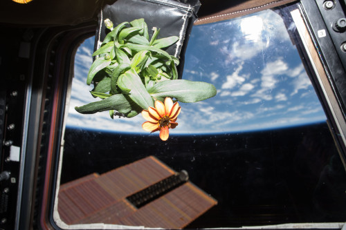
These images are of Zinnias. They are part of the flowering crop experiment that began aboard the International Space Station on Nov. 16, 2015, when NASA astronaut Kjell Lindgren activated the Veggie system and its rooting "pillows" containing zinnia seeds.
Make sure to follow us on Tumblr for your regular dose of space: http://nasa.tumblr.com.
Throwback Thursday: Frequently Asked Questions about Apollo

In celebration of the 50th anniversary of Apollo 11, we’ll be sharing answers to some frequently asked questions about the first time humans voyaged to the Moon. Answers have been compiled from archivists in the NASA History Office.
How many people worked on the Apollo program?

At the height of Apollo in 1965, about 409,900 people worked on some aspect of the program, but that number doesn’t capture it all.
It doesn’t represent the people who worked on mission concepts or spacecraft design, such as the engineers who did the wind tunnel testing of the Apollo Command Module and then moved on to other projects. The number also doesn’t represent the NASA astronauts, mission controllers, remote communications personnel, etc. who would have transferred to the Apollo program only after the end of Gemini program (1966-1967). There were still others who worked on the program only part-time or served on temporary committees. In the image above are three technicians studying an Apollo 14 Moon rock in the Lunar Receiving Laboratory at Johnson Space Center. From left to right, they are Linda Tyler, Nancy Trent and Sandra Richards.
How many people have walked on the Moon so far?

This artwork portrait done by spaceflight historian Ed Hengeveld depicts the 12 people who have walked on the Moon so far. In all, 24 people have flown to the Moon and three of them, John Young, Jim Lovell and Gene Cernan, have made the journey twice.
But these numbers will increase.
Are the U.S. flags that were planted on the Moon still standing?

Every successful Apollo lunar landing mission left a flag on the Moon but we don’t know yet whether all are still standing. Some flags were set up very close to the Lunar Module and were in the blast radius of its ascent engine, so it’s possible that some of them could have been knocked down. Neil Armstrong and Buzz Aldrin both reported that the flag had been knocked down following their ascent.

Our Lunar Reconnaissance Orbiter took photographs of all the Apollo lunar landing sites. In the case of the Apollo 17 site, you can see the shadow of the upright flag.
But why does it look like it’s waving?

The flags appear to “wave” or “flap” but actually they’re swinging. Swinging motions on Earth are dampened due to gravity and air resistance, but on the Moon any swinging motion can continue for much longer. Once the flags settled (and were clear of the ascent stage exhaust), they remained still. And how is the flag hanging? Before launching, workers on the ground had attached a horizontal rod to the top of each flag for support, allowing it to be visible in pictures and television broadcasts to the American public. Armstrong and Aldrin did not fully extend the rod once they were on the Moon, giving the flag a ripple effect. The other astronauts liked the ripple effect so much that they also did not completely extend the rod.
Why don’t we see stars in any of the pictures?

Have you ever taken a photo of the night sky with your phone or camera? You likely won’t see any stars because your camera’s settings are likely set to short exposure time which only lets it quickly take in the light off the bright objects closest to you. It’s the same reason you generally don’t see stars in spacewalk pictures from the International Space Station. There’s no use for longer exposure times to get an image like this one of Bruce McCandless in 1984 as seen from Space Shuttle Challenger (STS-41B).
The Hasselblad cameras that Apollo astronauts flew with were almost always set to short exposure times. And why didn’t the astronauts photograph the stars? Well, they were busy exploring the Moon!
When are we going back to the Moon?

The first giant leap was only the beginning. Work is under way to send the first woman and the next man to the Moon in five years. As we prepare to launch the next era of exploration, the new Artemis program is the first step in humanity’s presence on the Moon and beyond.
Keep checking back for more answers to Apollo FAQs.
Make sure to follow us on Tumblr for your regular dose of space: http://nasa.tumblr.com.

Artemis Astronauts Have Drills, Too!
Chances are, if you have ever spent time in a school or office building, you have experienced a fire drill. Well, astronauts practice emergency drills, too!

Since we began sending astronauts to space, we have used systems and drills to practice moving people safely away from the launch pad in the unlikely event of an emergency during the countdown to launch.

Early Mercury and Gemini programs in the 1960s used a launch escape system in the form of a solid rocket motor that could pull the astronauts to safety in the event of an emergency. However, this system only accounted for the astronauts, and not other personnel at the launch pad. NASA’s emergency systems have since improved substantially to include everyone.
Artemis II will be NASA’s first mission with crew aboard the SLS (Space Launch System) rocket and Orion spacecraft. Artemis II will fly around the Moon and come back to Earth. Beginning with the Artemis II mission, we will use a track cable to connect the mobile launcher — the ground structure that supports the rocket before and during launch — to the perimeter of the launch pad. Picture a gondola ski lift beginning at the top of the rocket and ending all the way down to the ground. In case of an emergency, astronauts and support crews move from the capsule into the crew access arm, climb into one of four baskets waiting for them, and ride down to the ground.

There, members of the Pad Rescue team are ready to scoop the astronauts up and whisk them to safety. Think of the Pad Rescue team as spaceflight knights in shining armor. Except instead of saving crew from a fire breathing dragon, they are whisking the astronauts away from a fully loaded skyscraper-sized rocket that’s getting ready to lift off.

The Artemis II mission will also introduce several new ground systems for the first time – including the new and improved braking system similar to what roller coasters use! Though no NASA mission to date has needed to use its ground-based emergency system during launch countdown, those safety measures are still in place and maintained as a top priority.
So the next time you practice a fire drill at school or at work, remember that these emergency procedures are important for everyone to stay safe — even astronauts.
Make sure to follow us on Tumblr for your regular dose of space!
Tour the Ocean through the Art of Sound
The ocean is one of the largest ecosystems on our planet. From eye-catching waves to the darkness of the twilight zone, it’s a place filled with mystery and rapid change.

For a scientist studying ocean color at NASA’s Goddard Space Flight Center in Greenbelt, Maryland, there was one more question–what does it sound like?
Before long, a “symphonic ocean experience” was born, combining satellite imagery, ocean color data and programming expertise. Learn more about how data gets converted to music and sound here:
This World Oceans Day, enjoy a tour of the ocean set to sound. Here we go:

Bering Sea
This melody explores the phytoplankton blooms in the western Bering Sea along the coast of the Kamchatka Peninsula collected by Aqua/MODIS on May 15, 2021. The melody created for this image was aimed at capturing the movement of the eddies or the circular movements of water. Data came from the image’s red, green, and blue channels.
Rio de la Plata
This melody explores a spring bloom in the South Atlantic Ocean off the coast of Argentina, Uruguay, and Brazil, lending the water many different shades of green, blue, and brown. The Rio de la Plata estuary in the northwest corner of the above image gets most of its tan coloration from sediments suspended in the water. The melody paired with the data evokes the sediment plumes and swirls happening off the coast.
Coral Sea
Data for the sounds of the Coral Sea were collected over the course of one year from the Aqua/Modis satellite. The information was extracted from a series of 32-day rolling averages for the year 2020, displaying the movement of chlorophyll a data.
Chlorophyll a is a specific form of chlorophyll used in photosynthesis. It absorbs most energy from wavelengths of violet-blue and orange-red light. It is a poor absorber of green and near-green portions of the spectrum, and that’s why it appears green.
Western Australia
Off the coast of western Australia is the appearance of swirls in the ocean. To catch the movement of the Indian Ocean, data was collected from 31 days of imagery examining blue wavelengths of light. The information was gathered from the Suomi-NPP/VIIRS instrument aboard the Joint Polar Satellite System (JPSS) series of spacecraft.
More moments of zen
Looking for more moments of zen? Explore them with NASA’s Soundcloud page, where many are out of this world. Curious on how we get these breathtaking ocean images? Take time to read about Goddard Oceanographer Norman Kuring and how he helped create them.
-
 anna8xin1 liked this · 5 months ago
 -
 oscar2022 reblogged this · 1 year ago
 -
 mankonfhippitua liked this · 1 year ago
 -
 exglorafda liked this · 1 year ago
 -
 twinmagics liked this · 1 year ago
 -
 watch reblogged this · 1 year ago
 -
 just-another-nerddd liked this · 3 years ago
 -
 iwantedamogusasmyblogname liked this · 3 years ago
 -
 meteoraferzie liked this · 3 years ago
Explore the universe and discover our home planet with the official NASA Tumblr account
1K posts