Solar System: Things To Know This Week
Solar System: Things to Know This Week
Our Juno mission has been exploring Jupiter since July 2016 with a special passenger on board: JunoCam, an instrument designed to take spectacular close-up color images of the largest planet in our solar system. From the raw images, citizen scientists have processed a range of beautiful photographs that highlight Jupiter's features, even turning them into works of art. Below, 10 stunning images JunoCam has given us over the past year.
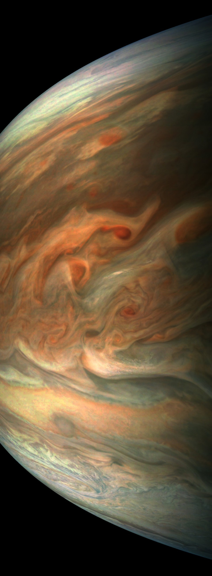
1. Jovian tempest.

This color-enhanced image of a massive, raging storm in Jupiter's northern hemisphere was captured by our Juno spacecraft during its ninth close flyby on Oct. 24, 2017. The storm is rotating counter-clockwise with a wide range of cloud altitudes, and the darker clouds are expected to be deeper in the atmosphere than the brightest clouds.
2. A southern stunner.

Jupiter's southern hemisphere shows off in beautiful detail in this image taken on Oct. 24, 2017. The color-enhanced view captures one of the white ovals in the "String of Pearls," one of eight massive rotating storms at 40 degrees south latitude on the gas giant planet.
3. Dreaming in color.

Artist Mik Petter created this unique digital piece using data from the JunoCam. The art form, known as fractals, uses mathematical formulas to create an infinite variety of form, detail, color and light. The original JunoCam image was taken on July 10, 2017.
4. Jovian moon shadow.

Jupiter's moon Amalthea casts a shadow on the gas giant planet in this image taken on Sept. 1, 2017. The elongated shape of the shadow is a result of both the location of the moon with relation to Jupiter in this image as well as the irregular shape of the moon itself.
5. 95 minutes over Jupiter.

Once every 53 days, Juno swings close to Jupiter, speeding over its clouds. In about two hours, the spacecraft travels from a perch over Jupiter's north pole through its closest approach (perijove), then passes over the south pole on its way back out. This sequence shows 11 color-enhanced images from Perijove 8 (Sept. 1, 2017) with the south pole on the left (11th image in the sequence) and the north pole on the right (first image in the sequence).
6. Soaring high.
This striking image of Jupiter was taken on Sept. 1, 2017 as Juno performed its eighth flyby. The spacecraft was 4,707 miles (7,576 kilometers) from the tops of the clouds of the planet at a latitude of about -17.4 degrees. Noteworthy: "Whale's Tail" and "Dan's Spot."
7. In true color.
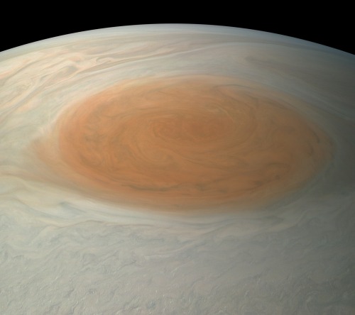
This true-color image offers a natural color rendition of what the Great Red Spot and surrounding areas would look like to human eyes from Juno's position. The image was taken on July 10, 2017 as the Juno spacecraft performed its seventh close flyby of Jupiter.
8. The 'face' of Jupiter.

JunoCam images aren't just for art and science—sometimes they're created for a good chuckle. This image, processed by citizen scientist Jason Major, is titled "Jovey McJupiterface." By rotating the image 180 degrees and orienting it from south up, two white oval storms turn into eyeballs, and the "face" of Jupiter is revealed. The original image was taken by the Juno spacecraft on May 19, 2017.
9. Bands of clouds.

This enhanced-color image of Jupiter's bands of light and dark clouds was created by citizen scientists Gerald Eichstädt and Seán Doran. Three of the white oval storms known as the "String of Pearls" are visible near the top of the image. Each of the alternating light and dark atmospheric bands in this image is wider than Earth, and each rages around Jupiter at hundreds of miles (kilometers) per hour. The lighter areas are regions where gas is rising, and the darker bands are regions where gas is sinking. Juno captured the image on May 19, 2017.
10. The edge.

This enhanced-color image of a mysterious dark spot on Jupiter seems to reveal a Jovian "galaxy" of swirling storms. Juno captured this image on Feb. 2, 2017 and citizen scientist Roman Tkachenko enhanced the color to bring out the rich detail in the storm and surrounding clouds. Just south of the dark storm is a bright, oval-shaped storm with high, bright, white clouds, reminiscent of a swirling galaxy. As a final touch, he rotated the image 90 degrees, turning the picture into a work of art.
To learn more about the Juno mission at Jupiter, visit: www.nasa.gov/juno.
Follow the Juno mission on Facebook, Instagram and Twitter.
Make sure to follow us on Tumblr for your regular dose of space: http://nasa.tumblr.com.
More Posts from Nasa and Others
We’re On a Mission to Study The Zone Where Earth Meets Space!
We’re launching ICON — short for Ionospheric Connection Explorer — a mission to explore the dynamic region where Earth meets space: the ionosphere!

Earth’s ionosphere stretches from 50 to 400 miles above the ground, overlapping the top of our atmosphere and the very beginning of space. The Sun cooks gases there until they lose an electron (or two or three), creating a sea of electrically charged particles. But, the ionosphere also responds to weather patterns from Earth rippling up. These changes are complex and tricky to understand.

That’s why we’re launching ICON! Changes in the ionosphere can affect astronauts, satellites and communications signals we use every day, like radio or GPS. Understanding these changes could help us eventually predict them — and better protect our technology and explorers in space.

ICON will track changes in the ionosphere by surveying airglow. It’s a natural feature of Earth’s that causes our atmosphere to constantly glow. The Sun excites gases in the upper atmosphere, so they emit light. From 360 miles above Earth, ICON will photograph airglow to measure the ionosphere’s winds, composition and temperature. ICON also carries an instrument that will capture and measure the particles directly around the spacecraft.

ICON is scheduled to launch on Oct. 10, on a Northrop Grumman Pegasus XL rocket. The night of launch, the rocket is flown up to the sky by Northrop Grumman’s L-1011 Stargazer airplane, which takes off from Cape Canaveral Air Force Station in Florida. From 40,000 feet above the open ocean, the Pegasus XL rocket drops from the plane and free-falls for about five seconds before igniting and carrying ICON into orbit.

NASA TV coverage of the launch starts at 9:15 p.m. EDT on Oct. 10 at nasa.gov/live. You can also follow along on Twitter, Facebook or at nasa.gov/icon.
Make sure to follow us on Tumblr for your regular dose of space: http://nasa.tumblr.com.

The trickster “Blinking Planetary”
Planetary nebula NGC 6826 is located about 4,200 light years from Earth in Cygnus. When observers look directly at it through a small telescope, they typically see only the nebula’s sparkling-white central star. However, by averting one’s gaze, glancing away from the central star, the nebula’s bulbous dust clouds come into view. This optical trickery earned this planetary nebula the name the "Blinking Planetary.”
Over the next several thousand years, the nebula will gradually disperse into space, and then the central star will slowly cool as it radiates its energy for billions of years as a white dwarf.
Make sure to follow us on Tumblr for your regular dose of space: http://nasa.tumblr.com
what has nasa and jpl learned from opportunity that has helped with developing this new project?
What are the different fields of Earth Science? Are they related to each other?
What is your advice to someone who wants to follow the same steps you take?
We See Seashores Shifting with Satellites
If you’re like us, as soon as the summer Sun is out, you start feeling – well, just beachy, sand you very much.
Lots of our favorite beaches are inside protected marine areas, which are regulated by governments to keep their ecosystems or cultural heritage intact. If you beachcomb at Cape Cod, swim in the Florida Keys or learn about Hawaiian culture at Papahānaumokuākea Marine National Monument, congrats! You’ve visited a protected marine area.

But time and tide haven’t been kind to some protected beaches.
Beaches are constantly changing, and science teams are using our 30-year record of Earth images from the NASA/USGS Landsat program to study what’s happening.
Overall, the sum total of sandy beaches has increased a bit over the last 30 years. But time and tide haven’t been as kind to our protected beaches – the team found that more than 1/3 of sandy beaches in protected marine areas have been eroding away.

Some of these areas were designated to protect vulnerable plant and animal species or connect delicate ecosystems. They are home to humpback whales and sea turtles, reefs and mangroves that protect the land from erosion and natural disasters, and species which are found in only one habitat in the world. Losing land area could upset the balance of these areas and endanger their future.

Next step: Looking for pearls of wisdom to save the beaches!
Right now, we aren’t sure which beaches are eroding due to natural processes, and which are due to humans – that’s the next step for science teams to investigate. Once we know the causes, we can start working on solutions to save the beaches.
Those 30 years of Landsat data will help scientists find answers to these questions much faster – instead of using airplanes or measuring the beaches by hand, they can use computer programs to rapidly investigate millions of satellite photos spanning many years of change.

By tracking beaches from space, scientists can help keep our summers sandy for years to come.
And that makes us as happy as clams.
Read the full story HERE.
Make sure to follow us on Tumblr for your regular dose of space: http://nasa.tumblr.com.
How did COVID19 affect your teamwork leading up to the launch? I hope everyone is staying well and sane:)

Take the Next Moon Step Challenge! Create an image of your footprint and tell us what you would say, in 20 words or less, if you were the next person to step foot on the Moon! Enter here: https://www.futureengineers.org/nextmoonstep
Tune in, Starliner! How NASA’s Near Space Network Powers Communications

On May 19, 2022, our partners at Boeing launched their Starliner CST-100 spacecraft to the International Space Station as a part of our Commercial Crew Program. This latest test puts the company one step closer to joining the SpaceX Crew Dragon in ferrying astronauts to and from the orbiting laboratory. We livestreamed the launch and docking at the International Space Station, but how? Let’s look at the communications and navigation infrastructure that makes these missions possible.

Primary voice and data communications are handled by our constellation of Tracking and Data Relay Satellites (TDRS), part of our Near Space Network. These spacecraft relay communications between the crewed vehicles and mission controllers across the country via terrestrial connections with TDRS ground stations in Las Cruces, New Mexico, and Guam, a U.S. territory in the Pacific Ocean.
TDRS, as the primary communications provider for the space station, is central to the services provided to Commercial Crew vehicles. All spacecraft visiting the orbiting laboratory need TDRS services to successfully complete their missions.

During launches, human spaceflight mission managers ensure that Commercial Crew missions receive all the TDRS services they need from the Near Space Operations Control Center at our Goddard Space Flight Center in Greenbelt, Maryland. There, communications engineers synthesize network components into comprehensive and seamless services for spacecraft as they launch, dock, undock, and deorbit from the space station.

Nearby, at our Flight Dynamics Facility, navigation engineers track the spacecraft on their ascent, leveraging years of experience supporting the navigation needs of crewed missions. Using tracking data sent to our Johnson Space Center in Houston and relayed to Goddard, these engineers ensure astronaut safety throughout the vehicles’ journey to the space station.
Additionally, our Search and Rescue office monitors emergency beacons on Commercial Crew vehicles from their lab at Goddard. In the unlikely event of a launch abort, the international satellite-aided search and rescue network will be able to track and locate these beacons, helping rescue professionals to return the astronauts safely. For this specific uncrewed mission, the search and rescue system onboard the Boeing Starliner will not be activated until after landing for ground testing.

To learn more about NASA’s Space Communications and Navigation (SCaN) services and technologies, visit https://www.nasa.gov/directorates/heo/scan/index.html. To learn more about NASA’s Near Space Network, visit https://esc.gsfc.nasa.gov/projects/NSN.
Make sure to follow us on Tumblr for your regular dose of space!
Do you have any protections against asteroids?
-
 cloverosita246 liked this · 5 months ago
 -
 newsmostbassiona liked this · 1 year ago
 -
 sulisusima liked this · 1 year ago
 -
 mizar2 reblogged this · 2 years ago
 -
 0815-4711-01 liked this · 2 years ago
 -
 zianiaa liked this · 2 years ago
 -
 mannofmisstery liked this · 3 years ago
 -
 elyre-the-liar liked this · 3 years ago
 -
 nocjourn reblogged this · 3 years ago
 -
nocjourn liked this · 3 years ago
-
 deeporangewishes reblogged this · 3 years ago
 -
deeporangewishes liked this · 3 years ago
-
 captainfrog96 liked this · 3 years ago
 -
 who-dat-b0i liked this · 4 years ago
 -
 lunagrimm777 liked this · 4 years ago
 -
 a-exists liked this · 4 years ago
 -
 bblobbsblog liked this · 4 years ago
 -
 illuminatiblog liked this · 4 years ago
 -
 mallinz reblogged this · 4 years ago
 -
 deadstrides liked this · 4 years ago
 -
 sevensimian liked this · 4 years ago
 -
 firstofthefours liked this · 4 years ago
 -
 rose1729 liked this · 4 years ago
 -
 lotusriver reblogged this · 4 years ago
 -
 xvenusxxx liked this · 5 years ago
 -
 q-108 liked this · 5 years ago
 -
 clembarbarossa liked this · 5 years ago
 -
 jiruchan reblogged this · 5 years ago
Explore the universe and discover our home planet with the official NASA Tumblr account
1K posts