Four Things ECOSTRESS Can See From Space
Four Things ECOSTRESS Can See From Space
Our new instrument in space, the Ecosystem Spaceborne Thermal Radiometer Experiment on Space Station (ECOSTRESS), is designed to study how plants respond to heat and water stress by measuring the temperature of Earth's vegetation, but that’s not all it will do. Adding ECOSTRESS to the Space Station will also add to our understanding of volcanoes, fires, urban heat and coastal and inland waters.

1. Fires
ECOSTRESS's radiometer can detect all kinds of fires, but it may be most useful in recording small fires – new wildfires that are just beginning to grow. These have proven hard to study from satellite observations. ECOSTRESS has a pixel size of only 130 by 230 feet (40 by 70 meters), offering a much sharper view. "We'll be able to see a bonfire on a beach," ECOSTRESS scientist Simon Hook says.

Credit: USGS
2. Volcanoes
ECOSTRESS's thermal infrared imager will be able to spot new fissures and hotspots that can signal impending volcanic eruptions.

The Chiliques volcano in Chile was thought to be dormant until thermal images revealed new activity. Credit: NASA/METI/AIST/Japan Space Systems and U.S./Japan ASTER Science Team
3. Urban Heat
The heat generated by a large city can compound the health hazards of heat waves, particularly for the oldest and youngest city dwellers. Which neighborhoods suffer from heat the most? With the very detailed images from ECOSTRESS, we'll be able to see which mitigation efforts are keeping neighborhoods cool.

Urban areas can be up to 8 degrees warmer than surrounding suburban or natural landscapes, as seen here in a true-color image of the Atlanta area, top, and temperature data, bottom. Credit: NASA
4. Coastal and Inland Waters
Along coastlines and in large lakes, wind can push surface water aside allowing water from the depths to rise to the surface, bringing nutrients. These upwellings of cold water are important sources of nutrition for the coastal and lake plants and animals. ECOSTRESS can detect these smaller upwellings, providing valuable information for researchers.

Upwelling can be seen in satellite data. Here temperature data (top) and chlorophyll concentrations (bottom) are shown around the Isthmus of Tehuantepec in Mexico. Credit: MODIS Ocean Color Team/Norman Kuring
Read more about the ECOSTRESS mission at https://ecostress.jpl.nasa.gov/. Make sure to follow us on Tumblr for your regular dose of space: http://nasa.tumblr.com
More Posts from Nasa and Others
See the Universe in a New Way with the Webb Space Telescope's First Images
Are you ready to see unprecedented, detailed views of the universe from the James Webb Space Telescope, the largest and most powerful space observatory ever made? Scroll down to see the first full-color images and data from Webb. Unfold the universe with us. ✨
Carina Nebula

This landscape of “mountains” and “valleys” speckled with glittering stars, called the Cosmic Cliffs, is the edge of the star-birthing Carina Nebula. Usually, the early phases of star formation are difficult to capture, but Webb can peer through cosmic dust—thanks to its extreme sensitivity, spatial resolution, and imaging capability. Protostellar jets clearly shoot out from some of these young stars in this new image.
Southern Ring Nebula

The Southern Ring Nebula is a planetary nebula: it’s an expanding cloud of gas and dust surrounding a dying star. In this new image, the nebula’s second, dimmer star is brought into full view, as well as the gas and dust it’s throwing out around it. (The brighter star is in its own stage of stellar evolution and will probably eject its own planetary nebula in the future.) These kinds of details will help us better understand how stars evolve and transform their environments. Finally, you might notice points of light in the background. Those aren’t stars—they’re distant galaxies.
Stephan’s Quintet

Stephan’s Quintet, a visual grouping of five galaxies near each other, was discovered in 1877 and is best known for being prominently featured in the holiday classic, “It’s a Wonderful Life.” This new image brings the galaxy group from the silver screen to your screen in an enormous mosaic that is Webb’s largest image to date. The mosaic covers about one-fifth of the Moon’s diameter; it contains over 150 million pixels and is constructed from almost 1,000 separate image files. Never-before-seen details are on display: sparkling clusters of millions of young stars, fresh star births, sweeping tails of gas, dust and stars, and huge shock waves paint a dramatic picture of galactic interactions.
WASP-96 b

WASP-96 b is a giant, mostly gas planet outside our solar system, discovered in 2014. Webb’s Near-Infrared Imager and Slitless Spectrograph (NIRISS) measured light from the WASP-96 system as the planet moved across the star. The light curve confirmed previous observations, but the transmission spectrum revealed new properties of the planet: an unambiguous signature of water, indications of haze, and evidence of clouds in the atmosphere. This discovery marks a giant leap forward in the quest to find potentially habitable planets beyond Earth.
Webb's First Deep Field

This image of galaxy cluster SMACS 0723, known as Webb’s First Deep Field, looks 4.6 billion years into the past. Looking at infrared wavelengths beyond Hubble’s deepest fields, Webb’s sharp near-infrared view reveals thousands of galaxies—including the faintest objects ever observed in the infrared—in the most detailed view of the early universe to date. We can now see tiny, faint structures we’ve never seen before, like star clusters and diffuse features and soon, we’ll begin to learn more about the galaxies’ masses, ages, histories, and compositions.
These images and data are just the beginning of what the observatory will find. It will study every phase in the history of our Universe, ranging from the first luminous glows after the Big Bang, to the formation of solar systems capable of supporting life on planets like Earth, to the evolution of our own Solar System.
Make sure to follow us on Tumblr for your regular dose of space—and for milestones like this!
Credits: NASA, ESA, CSA, and STScI
Countdown to Launch of Landsat 9
We’re launching Landsat 9 — the ninth in a series of satellite missions from NASA and the U.S. Geological Survey (USGS) that have been collecting images of our planet for almost 50 years. Follow along as we count down to launch!

A normal launch countdown starts at 10, but for Landsat 9, we’re jumping in with L-9!
There are 9 million images in the USGS/NASA Landsat archive! They’re all available for free, for use by scientists, data managers, and anyone else who’s interested. You can even download them!

Landsat 9 won’t be orbiting alone. Working together, Landsat 9 and Landsat 8 will completely image Earth every 8 days! This helps us track changes on the planet’s surface as they happen in near-real-time.

Landsat sees all 7 continents! From Antarctic ice to growing cities to changing forests, Landsat measures land — and coastal regions — all around the globe.

Working in space is really hard. Landsat 6 never made it to orbit, an important reminder that failures can be opportunities to learn and grow. Shortly after the unsuccessful launch, engineers got to work on Landsat 7, which is still collecting data today — 22 years later.

We have 5 decades of Landsat observations, the longest continuous record of Earth’s land surfaces in existence! While building the original Landsat in the 1970s, it would have been hard to imagine that this mission would still be providing crucial data about our planet today.

For each color band collected, Landsat 9 will see 4 times the shades of light as the previous Landsat mission! With more than 16,000 different intensities detected, Landsat 9 will be able to see crucial details on our planet’s surface.

Our eyes detect 3 colors of light: red, green, and blue — and Landsat does too! But Landsat 9 also detects wavelengths that can be combined to measure things our eyes can’t, like crop stress, coral reef health, fires, and more.

There are 2 instruments on Landsat 9! The Operational Land Imager 2 collects light, and works kind of like our eyes — or cameras — to make data-rich images. The Thermal Infrared Sensor 2 measures temperature, helping monitor plant health, fires, and more.

The Landsat program is the result of 1 amazing partnership! For more than 50 years, we’ve worked with the U.S. Geological Survey to design, build, launch, and manage Landsat satellites.

Two agencies working together makes for the longest continuous record of Earth’s surfaces. Now, let’s launch this satellite!
Make sure to follow us on Tumblr for your regular dose of space!
Why is the final phase so difficult?Sorry if I sound dumb,I'm just curious.Also,what will be the rover's first task after landing?

Ever want to ask a real life astronaut a question? Here’s your chance!
We are kicking off Hispanic Heritage Month a little early this year, and astronaut Serena M. Auñón-Chancellor will be taking your questions in an Answer Time session on Thursday, September 12 from 12pm - 1pm ET here on NASA’s Tumblr! Find out what it’s like to be a NASA astronaut and learn more about her Cuban-American heritage. Make sure to ask your question now by visiting http://nasa.tumblr.com/ask!
Dr. Serena M. Auñón-Chancellor began working with NASA as a Flight Surgeon in 2006 and was later selected as a NASA astronaut in 2009. Her first flight was from Jun 6- Dec. 20, 2018 where she served as Flight Engineer on the International Space Station as a member of Expeditions 56 and 57. During these missions, the crew contributed to hundreds of experiments in biology, biotechnology, physical science and Earth science – including investigations into a new cancer treatment!
She has a Bachelor of Science in Electrical Engineering from The George Washington University, Washington, D.C and a Doctorate of Medicine from The University of Texas - Health Science Center at Houston.
Dr. Auñón-Chancellor Fun Facts:
She spent 2 months in Antarctica from 2010 to 2011 searching for meteorites as part of the ANSMET expedition.
She served as an Aquanaut on the NEEMO 20 mission in the Aquarius underwater laboratory, which is used to prepare for living and working in space.
She logged 197 days in space during Expeditions 56 and 57.
Follow Serena on Twitter at @AstroSerena and follow NASA on Tumblr for your regular dose of space.
Solar System: 10 Things to Know
Movie Night
Summer break is just around the corner. Hang a sheet from the clothesline in the backyard and fire up the projector for a NASA movie night.
1. Mars in a Minute

Back in the day, movies started with a cartoon. Learn the secrets of the Red Planet in these animated 60 second chunks.
2. Crash of the Titans

Watch two galaxies collide billions of years from now in this high-definition visualization.
3. Tour the Moon in 4K

Wait for the dark of the waning Moon next weekend to take in this 4K tour of our constant celestial companion.
4. Seven Years of the Sun

Watch graceful dances in the Sun’s atmosphere in this series of videos created by our 24/7 Sun-sentinel, the Solar Dynamic Observatory (SDO).
5. Light ‘Em Up

Crank up the volume and learn about NASA science for this short video about some of our science missions, featuring a track by Fall Out Boy.
6. Bennu’s Journey

Follow an asteroid from its humble origins to its upcoming encounter with our spacecraft in this stunning visualization.
7. Lunar Landing Practice
Join Apollo mission pilots as they fly—and even crash—during daring practice runs for landing on the Moon.
8. Earthrise

Join the crew of Apollo 8 as they become the first human beings to see the Earth rise over the surface of the Moon.
9. Musical Descent to Titan

Watch a musical, whimsical recreation of the 2005 Huygens probe descent to Titan, Saturn’s giant moon.
10. More Movies

Our Goddard Scientific Visualization Studio provides a steady stream of fresh videos for your summer viewing pleasure. Come back often and enjoy.
Read the full version of this article on the web HERE.
Make sure to follow us on Tumblr for your regular dose of space: http://nasa.tumblr.com.

Take the Next Moon Step Challenge! Create an image of your footprint and tell us what you would say, in 20 words or less, if you were the next person to step foot on the Moon! Enter here: https://www.futureengineers.org/nextmoonstep
What exactly is a sun eclipse? Will I be able to see it and if so when from the Netherlands?
The solar eclipse is when the moon is directly in front of the Sun and creates a shadow on the Earth. They happen about once every 18 months. I don’t believe that you’ll be able to see this eclipse from the Netherlands. I think the next one to be in Europe is in 2026. There’s one in Chillie and Argentia in 2019 and another in Antartica in 2021.
A Wrinkle in Space-Time: The Eclipse That “Proved” Einstein Right
One hundred years ago a total solar eclipse turned an obscure scientist into a household name. You might have heard of him — his name is Albert Einstein. But how did a solar eclipse propel him to fame?
First, it would be good to know a couple things about general relativity. (Wait, don’t go! We’ll keep this to the basics!)

A decade before he finished general relativity, Einstein published his special theory of relativity, which demonstrates how space and time are interwoven as a single structure he dubbed “space-time.” General relativity extended the foundation of special relativity to include gravity. Einstein realized that gravitational fields can be understood as bends and curves in space-time that affect the motions of objects including stars, planets — and even light.
For everyday situations the centuries-old description of gravity by Isaac Newton does just fine. However, general relativity must be accounted for when we study places with strong gravity, like black holes or neutron stars, or when we need very precise measurements, like pinpointing a position on Earth to within a few feet. That makes it hard to test!

A prediction of general relativity is that light passing by an object feels a slight "tug", causing the light's path to bend slightly. The more mass the object has, the more the light will be deflected. This sets up one of the tests that Einstein suggested — measuring how starlight bends around the Sun, the strongest source of gravity in our neighborhood. Starlight that passes near the edge of the Sun on its way to Earth is deflected, altering by a small amount where those stars appear to be. How much? By about the width of a dime if you saw it at a mile and a quarter away! But how can you observe faint stars near the brilliant Sun? During a total solar eclipse!

That’s where the May 29, 1919, total solar eclipse comes in. Two teams were dispatched to locations in the path of totality — the places on Earth where the Moon will appear to completely cover the face of the Sun during an eclipse. One team went to South America and another to Africa.
On eclipse day, the sky vexed both teams, with rain in Africa and clouds in South America. The teams had only mere minutes of totality during which to take their photographs, or they would lose the opportunity until the next total solar eclipse in 1921! However, the weather cleared at both sites long enough for the teams to take images of the stars during totality.

The teams took two sets of photographs of the same patch of sky – one set during the eclipse and another set a few months before or after, when the Sun was out of the way. By comparing these two sets of photographs, researchers could see if the apparent star positions changed as predicted by Einstein. This is shown with the effect exaggerated in the image above.
A few months after the eclipse, when the teams sorted out their measurements, the results demonstrated that general relativity correctly predicted the positions of the stars. Newspapers across the globe announced that the controversial theory was proven (even though that’s not quite how science works). It was this success that propelled Einstein into the public eye.

The solar eclipse wasn’t the first test of general relativity. For more than two centuries, astronomers had known that Mercury’s orbit was a little off. Its perihelion — the point during its orbit when it is closest to the Sun — was changing faster than Newton’s laws predicted. General relativity easily explains it, though, because Mercury is so close to the Sun that its orbit is affected by the Sun’s dent in space-time, causing the discrepancy.
In fact, we still test general relativity today under different conditions and in different situations to see whether or not it holds up. So far, it has passed every test we’ve thrown at it.
Curious to know where we need general relativity to understand objects in space? Tune into our Tumblr tomorrow to find out!

You can also read more about how our understanding of the universe has changed during the past 100 years, from Einstein's formulation of gravity through the discovery of dark energy in our Cosmic Times newspaper series.
Make sure to follow us on Tumblr for your regular dose of space: http://nasa.tumblr.com.
Mercury In the Spotlight
For more than seven hours on Monday, May 9, Mercury will be visible as a tiny black dot crossing the face of the sun. This rare event – which happens only slightly more than once a decade – is called a transit.

Although Mercury whips around the sun every 88 days – over four times faster than Earth – the three bodies rarely align. Because Mercury orbits in a plane 7 degrees tilted from Earth’s orbit, it usually darts above or below our line of sight to the sun. As a result, a Mercury transit happens only about 13 times a century. The last one was in 2006, and the next one isn’t until 2019.

When: On May 9, shortly after 7:00 a.m. EDT, Mercury will appear as a tiny black dot against a blazing backdrop, traversing the sun’s disk over seven and a half hours. Mercury will cross the edge of the sun (ingress) after 7:00 a.m. EDT. The mid-transit point will occur a little after 10:45 a.m. EDT, with egress around 2:30 p.m. EDT.
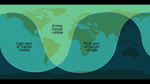
Where: Skywatchers in Western Europe, South America and eastern North America will be able to see the entirety of the transit. The entire 7.5-hour path across the sun will be visible across the Eastern U.S. – with magnification and proper solar filters – while those in the West can observe the transit in progress at sunrise.

Safety!
Unlike the 2012 Venus transit of the sun, Mercury is too small to be visible without magnification from a telescope or high-powered binoculars. Both must have safe solar filters made of specially-coated glass or Mylar; you can never look directly at the sun. We’re offering several avenues for the public to view the event without specialized and costly equipment, including images on NASA.gov, a one-hour NASA Television special, and social media coverage.

The Science…Why are Planetary Transits Important?
Transits like this allowed scientists in the 17th century to make the first estimates of Earth’s distance from the sun. Transit observations over the past few centuries have also helped scientists study everything from the atmosphere of Venus to the slight shifts in Mercury’s orbit that could only be explained by the theory of general relativity. Because we know Mercury’s size and location precisely, this transit will help scientists calibrate telescopes on solar observatories SDO, SOHO, and Hinode.

Transits can also teach us more about planets – both in and out of our solar system. The Venus transit in 2012 provided observations of the planet's atmosphere. Transits are also the main way we find planets outside the solar system, called exoplanets.

The transit method looks for a drop in the brightness of a star when a planet passes in front of it. This method will not find every planet – only those that happen to cross our line of sight from Earth to the star. But with enough sensitivity, the transit method through continuous monitoring is a great way to detect small, Earth-size planets, and has the advantage of giving us both the planet’s size (from the fraction of starlight blocked), as well as its orbit (from the period between transits). Our Kepler/K2 mission uses this method to find exoplanets, as will the Transiting Exoplanet Survey Satellites, or TESS, following its launch in 2017/2018.
We will stream a live program on NASA TV and the agency’s Facebook page from 10:30 to 11:30 a.m. -- an informal roundtable during which experts representing planetary, heliophysics and astrophysics will discuss the science behind the Mercury transit. Viewers can ask questions via Facebook and Twitter using #AskNASA.
Make sure to follow us on Tumblr for your regular dose of space: http://nasa.tumblr.com
Smoke Gets In Your Eyes…and Our Instruments
Fires are some of the most dynamic and dramatic natural phenomena. They can change rapidly, burning natural landscapes and human environments alike. Fires are a natural part of many of Earth’s ecosystems, necessary to replenish soil and for healthy plant growth. But, as the planet warms, fires are becoming more intense, burning longer and hotter.

Right now, a fleet of vehicles and a team of scientists are in the field, studying how smoke from those fires affects air quality, weather and climate. The mission? It’s called FIREX-AQ. They’re working from the ground up to the sky to measure smoke, find out what’s in it, and investigate how it affects our lives.

Starting on the ground, the Langley Aerosol Research Group Experiment (LARGE) operates out of a large van. It’s one of two such vans working with the campaign, along with some other, smaller vans. It looks a little like a food truck, but instead of a kitchen, the inside is packed full of science instruments.

The team drives the van out into the wilderness to take measurements of smoke and tiny particles in the air at the ground level. This is important for a few reasons: First of all, it’s the stuff we’re breathing! It also gives us a look at smoke overnight, when the plumes tend to sink down out of the atmosphere and settle near the ground until temperatures heat back up with the Sun. The LARGE group camps out with their van full of instruments, taking continuous measurements of smoke…and not getting much sleep.

Just a little higher up, NOAA’s Twin Otter aircraft can flit down close to where the fires are actually burning, taking measurements of the smoke and getting a closer look at the fires themselves. The Twin Otters are known as “NOAA’s workhorses” because they’re easily maneuverable and can fly nice and slow to gather measurements, topping out at about 17,000 feet.

Then, sometimes flying at commercial plane height (30,000 feet) and swooping all the way down to 500 feet above the ground, NASA’s DC-8 is packed wing to wing with science instruments. The team onboard the DC-8 is looking at more than 500 different chemicals in the smoke.

The DC-8 does some fancy flying, crisscrossing over the fires in a maneuver called “the lawnmower” and sometimes spiraling down over one vertical column of air to capture smoke and particles at all different heights. Inside, the plane is full of instrument racks and tubing, capturing external air and measuring its chemical makeup. Fun fact: The front bathroom on the DC-8 is closed during science flights to make sure the instruments don’t accidentally measure anything ejected from the plane.

Finally, we make it all the way up to space. We’ve got a few different mechanisms for studying fires already mounted on satellites. Some of the satellites can see where active fires are burning, which helps scientists and first responders keep an eye on large swaths of land.

Some satellites can see smoke plumes, and help researchers track them as they move across land, blown by wind.

Other satellites help us track weather and forecast how the fires might behave. That’s important for keeping people safe, and it helps the FIREX-AQ team know where to fly and drive when they’ll get the most information. These forecasts use computer models, based on satellite observations and data about how fires and smoke behave. FIREX-AQ’s data will be fed back into these models to make them even more accurate.

Learn more about how NASA is studying fires from the field, here.
Make sure to follow us on Tumblr for your regular dose of space: http://nasa.tumblr.com.
-
 najyxo liked this · 1 year ago
 -
 dahinterdasgesicht liked this · 3 years ago
 -
 5yin liked this · 4 years ago
 -
 kraftundlicht liked this · 4 years ago
 -
 franklinsantos liked this · 4 years ago
 -
 alexis-asterix liked this · 4 years ago
 -
 ilovegirlswithglasses1 liked this · 4 years ago
 -
 mazzardpie liked this · 4 years ago
 -
 dallydewdrop reblogged this · 4 years ago
 -
dallydewdrop liked this · 4 years ago
-
 spasticalactica liked this · 4 years ago
 -
 pattersonba liked this · 5 years ago
 -
 mrightfuljug63 liked this · 5 years ago
 -
 metinkso liked this · 5 years ago
 -
 le-petitte-demon-horse liked this · 6 years ago
 -
 thekiltedginger liked this · 6 years ago
 -
 sillymongerstudenthairdo-blog liked this · 6 years ago
 -
 wielderofscythes reblogged this · 6 years ago
 -
wielderofscythes liked this · 6 years ago
-
 stevia333k reblogged this · 6 years ago
 -
stevia333k liked this · 6 years ago
-
 jecroisauxlicornes reblogged this · 6 years ago
 -
jecroisauxlicornes liked this · 6 years ago
-
 makenoteofit reblogged this · 6 years ago
 -
 findingdeeperspaces liked this · 6 years ago
 -
 atchiu-ruad reblogged this · 6 years ago
 -
 two2ds reblogged this · 6 years ago
 -
 llaevateinn reblogged this · 6 years ago
 -
 theravenofwynter reblogged this · 6 years ago
 -
 jazzyvix reblogged this · 6 years ago
 -
 astra-peraspera reblogged this · 6 years ago
 -
 randomavatarfan reblogged this · 6 years ago
 -
 fleurdebach5-blog liked this · 6 years ago
 -
 celestialdragon-system-blog liked this · 6 years ago
 -
 cn-real reblogged this · 6 years ago
 -
 cloudair liked this · 6 years ago
 -
 leilabug13 reblogged this · 6 years ago
 -
 gentianablue reblogged this · 6 years ago
 -
 cruisenjoe reblogged this · 6 years ago
 -
gentianablue liked this · 6 years ago
-
 cripple-cat liked this · 6 years ago
Explore the universe and discover our home planet with the official NASA Tumblr account
1K posts