If #NationalCheeseDay Has You Thinking About The Moon, You're Not Alone. 🧀
If #NationalCheeseDay has you thinking about the Moon, you're not alone. 🧀
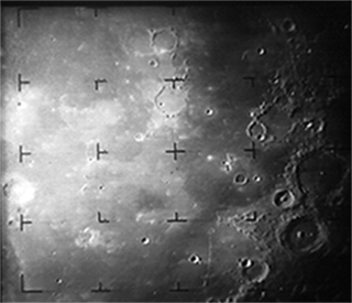
In 1965, the Ranger 9 probe captured these sharp images of a cratered lunar surface just moments before its planned impact. What we learned paved the way for Apollo. #Apollo50th
More Posts from Nasa and Others
8 Common Questions About Our James Webb Space Telescope
You might have heard the basics about our James Webb Space Telescope, or Webb, and still have lots more questions! Here are more advanced questions we are frequently asked. (If you want to know the basics, read this Tumblr first!)
Webb is our upcoming infrared space observatory, which will launch in 2021. It will spy the first luminous objects that formed in the universe and shed light on how galaxies evolve, how stars and planetary systems are born, and how life could form on other planets.
1. Why is the mirror segmented?
The James Webb Space Telescope has a 6.5-meter (21.3-foot) diameter mirror, made from 18 individual segments. Webb needs to have an unfolding mirror because the mirror is so large that it otherwise cannot fit in the launch shroud of currently available rockets.

The mirror has to be large in order to see the faint light from the first star-forming regions and to see very small details at infrared wavelengths.

Designing, building, and operating a mirror that unfolds is one of the major technological developments of Webb. Unfolding mirrors will be necessary for future missions requiring even larger mirrors, and will find application in other scientific, civil, and military space missions.
2. Why are the mirrors hexagonal?
In short, the hexagonal shape allows a segmented mirror to be constructed with very small gaps, so the segments combine to form a roughly circular shape and need only three variations in prescription. If we had circular segments, there would be gaps between them.

Finally, we want a roughly circular overall mirror shape because that focuses the light into the most symmetric and compact region on the detectors.

An oval mirror, for example, would give images that are elongated in one direction. A square mirror would send a lot of the light out of the central region.
3. Is there a danger from micrometeoroids?
A micrometeoroid is a particle smaller than a grain of sand. Most never reach Earth's surface because they are vaporized by the intense heat generated by the friction of passing through the atmosphere. In space, no blanket of atmosphere protects a spacecraft or a spacewalker.
Webb will be a million miles away from the Earth orbiting what we call the second Lagrange point (L2). Unlike in low Earth orbit, there is not much space debris out there that could damage the exposed mirror.

But we do expect Webb to get impacted by these very tiny micrometeoroids for the duration of the mission, and Webb is designed to accommodate for them.

All of Webb's systems are designed to survive micrometeoroid impacts.
4. Why does the sunshield have five layers?
Webb has a giant, tennis-court sized sunshield, made of five, very thin layers of an insulating film called Kapton.
Why five? One big, thick sunshield would conduct the heat from the bottom to the top more than would a shield with five layers separated by vacuum. With five layers to the sunshield, each successive one is cooler than the one below.

The heat radiates out from between the layers, and the vacuum between the layers is a very good insulator. From studies done early in the mission development five layers were found to provide sufficient cooling. More layers would provide additional cooling, but would also mean more mass and complexity. We settled on five because it gives us enough cooling with some “margin” or a safety factor, and six or more wouldn’t return any additional benefits.
Fun fact: You could nearly boil water on the hot side of the sunshield, and it is frigid enough on the cold side to freeze nitrogen!
5. What kind of telescope is Webb?

Webb is a reflecting telescope that uses three curved mirrors. Technically, it’s called a three-mirror anastigmat.
6. What happens after launch? How long until there will be data?
We’ll give a short overview here, but check out our full FAQ for a more in-depth look.
In the first hour: About 30 minutes after liftoff, Webb will separate from the Ariane 5 launch vehicle. Shortly after this, we will talk with Webb from the ground to make sure everything is okay after its trip to space.

In the first day: After 24 hours, Webb will be nearly halfway to the Moon! About 2.5 days after launch, it will pass the Moon’s orbit, nearly a quarter of the way to Lagrange Point 1 (L2).

In the first week: We begin the major deployment of Webb. This includes unfolding the sunshield and tensioning the individual membranes, deploying the secondary mirror, and deploying the primary mirror.

In the first month: Deployment of the secondary mirror and the primary mirror occur. As the telescope cools in the shade of the sunshield, we turn on the warm electronics and initialize the flight software. As the telescope cools to near its operating temperature, parts of it are warmed with electronic heaters. This prevents condensation as residual water trapped within some of the materials making up the observatory escapes into space.

In the second month: We will turn on and operate Webb’s Fine Guidance Sensor, NIRCam, and NIRSpec instruments.

The first NIRCam image, which will be an out-of-focus image of a single bright star, will be used to identify each mirror segment with its image of a star in the camera. We will also focus the secondary mirror.

In the third month: We will align the primary mirror segments so that they can work together as a single optical surface. We will also turn on and operate Webb’s mid-infrared instrument (MIRI), a camera and spectrograph that views a wide spectrum of infrared light. By this time, Webb will complete its journey to its L2 orbit position.

In the fourth through the sixth month: We will complete the optimization of the telescope. We will test and calibrate all of the science instruments.
After six months: The first scientific images will be released, and Webb will begin its science mission and start to conduct routine science operations.

7. Why not assemble it in orbit?
Various scenarios were studied, and assembling in orbit was determined to be unfeasible.
We examined the possibility of in-orbit assembly for Webb. The International Space Station does not have the capability to assemble precision optical structures. Additionally, space debris that resides around the space station could have damaged or contaminated Webb’s optics. Webb’s deployment happens far above low Earth orbit and the debris that is found there.

Finally, if the space station were used as a stopping point for the observatory, we would have needed a second rocket to launch it to its final destination at L2. The observatory would have to be designed with much more mass to withstand this “second launch,” leaving less mass for the mirrors and science instruments.
8. Who is James Webb?
This telescope is named after James E. Webb (1906–1992), our second administrator. Webb is best known for leading Apollo, a series of lunar exploration programs that landed the first humans on the Moon.

However, he also initiated a vigorous space science program that was responsible for more than 75 launches during his tenure, including America's first interplanetary explorers.
Looking for some more in-depth FAQs? You can find them HERE.
Learn more about the James Webb Space Telescope HERE, or follow the mission on Facebook, Twitter and Instagram.
Make sure to follow us on Tumblr for your regular dose of space!
What’s Up for July 2016?

What's Up for July? Use Saturn as your guide to a tour of the summer Milky Way.

Saturn continues to dazzle this month. Its wide rings and golden color provide a nice contrast to nearby Mars and Antares. Below Saturn lies the constellation Scorpius, which really does look like a scorpion!

Through binoculars or telescopes you'll be able to spot two pretty star clusters: a compact (or globular) cluster, M-4, and an open cluster, M-7. M-7 is known as Ptolemy's cluster. It was observed and cataloged by Greek-Egyptian astronomer Ptolemy in the first century.

Climbing north, you'll be able to spot the teapot shape which forms part of the constellation Sagittarius. The center of the Milky Way is easy to see. It looks like bright steam rising from the teapot's spout.

With difficulty, a good star chart and a medium-sized telescope you can locate faint Pluto in the "teaspoon" adjacent to the teapot.

A binocular tour of this center core of the Milky Way reveals many beautiful summer sky objects. We first encounter the Eagle Nebula, M-16. Part of this nebula is featured in the famous and beautiful "Pillars of Creation" images taken by our Hubble Space Telescope.

You'll have to stay up later to see the northern Milky Way constellations, which are better placed for viewing later in the summer and fall. Cygnus the swan features the prettiest supernova remnant in the entire sky, the Veil Nebula. It's too big to fit in one eyepiece view, but luckily there are three sections of it.

Look between Aquila and Cygnus to find three tiny constellations: Delphinus the dolphin, Vulpecula the fox and Lyra the lyre (or harp). M-57, the Ring Nebula, is the remains from a shell of ionized gas expelled by a red giant star into the surrounding interstellar medium. It's pretty, too! Look in Vulpecula for the Dumbbell, another planetary nebula.

We'll end our summer tour with Lacerta the lizard and Draco the Dragon. Lacerta is home to a star with an extrasolar planet in its orbit, and Draco, facing away from the center of our Milky Way, is a treasure trove of distant galaxies to catch in your telescope.
Watch the full What’s Up for July 2016 video HERE.
You can catch up on current missions and space telescopes studying our Milky Way and beyond at www.nasa.gov.
Make sure to follow us on Tumblr for your regular dose of space: http://nasa.tumblr.com

Spinoffs: Space Station Innovations in Your Cart (and Heart!)
You might think NASA technology is just spaceships and telescopes, but did you know the camera in your cell phone is, too? It’s one of many NASA innovations now found everywhere on Earth.
The International Space Station has had crew living on it for 25 years straight. In that time, the space station has enabled a tremendous amount of research, helping NASA and scientists better understand long-term living in space – but it’s not just knowledge coming back down to Earth! Technologies developed for the space station and experiments conducted aboard the orbiting lab also benefit people on the planet below. Here are a few of these inventions, or spinoffs, you can find in your everyday life.

A Sunscreen That Blocks Radiation in Space – and on Your Face
After surviving for 18 months outside the International Space Station, an extremely hardy organism is now improving sunscreens and face cream products from a cosmetics company, which licensed use of the organism from NASA’s Jet Propulsion Laboratory.


Build Muscle With or Without Gravity
Muscles atrophy quickly in space, so when astronauts began long stays on the International Space Station, they needed some specialized exercise equipment. A resistance mechanism made of a coiled metal spring formed the basis of the first way for astronauts to “lift weights” in space. Soon after, that same design became the heart of compact home gym equipment.

Fresh Greens Every Day of the Year
The need to grow fresh food in space pushed NASA to develop indoor agriculture techniques. Thanks to the agency’s research, private companies are building on NASA’s vertical farm structure, plant-growth “recipes,” and environmental-control data to create indoor farms, resulting in higher crop yields and better-quality produce while conserving water and energy and eliminating the need for pesticides.

Cultivating Hearts and Knees in Space
Gravity is a significant obstacle to bioprinting cells and growing human tissue on Earth because heavier components settle to the bottoms of petri dishes. In the absence of gravity, each cell layer stays in place, which is how it’s possible to grow heart and knee tissue on the space station. The same principle also allows mixing of complex pharmaceuticals on orbit.

Storing Oodles of Energy
NASA chose nickel-hydrogen batteries to power the Hubble Space Telescope and the International Space Station because the technology is safe, reliable in extreme temperatures, and long-lived. NASA’s improvements brought down the cost of the technology, which is now used by large-scale utilities and renewable power plants that need to store energy generated by intermittent sources.
You can read about many more products sourced from the ISS on spinoff.nasa.gov.
Make sure to follow us on Tumblr for your regular dose of space!
Solar System: Things to Know This Week
Learn about Earth’s nearest neighbors, the moon, near Earth asteroids, and more this week.

1. Cosmic, Man
The fifth International Cosmic Day will take place on Nov. 2. This event will bring students, teachers and scientists together to talk and learn about cosmic rays, energetic particles from deep space. Participants will learn more about cosmic rays, and can also carry out their own measurements and get in contact with groups all over the world to compare and discuss their results.
+ Join in

2. Meet Our Neighbors
The number of near-Earth asteroids (NEAs) discovered now tops 15,000, with an average of 30 added each week. "While no known NEA currently poses a risk of impact with Earth over the next 100 years," says NASA Planetary Defense Officer Lindley Johnson. "We've found mostly the larger asteroids...we have a lot more of the smaller, but still potentially hazardous ones, to find."
+ Find out how we keep watch

3. Written in the Scars
The moon wasn't always so lucky when it came to avoiding impacts. New results from our Gravity Recovery and Interior Laboratory (GRAIL) mission are providing insights into the huge impacts that dominated the early history of Earth's moon--and other solid worlds like Earth and Mars.
+ See more

4. Raw Beauty
Our Cassini spacecraft regularly returns spectacular images from Saturn. What you may not realize is that even before they've been processed by Cassini imaging specialists, these pictures are published online in raw, unprocessed form, almost the moment they come down to Earth.
+ See for yourself

5. Photobomb!
On Oct. 30, 2016, the Solar Dynamics Observatory, or SDO, experienced a partial solar eclipse in space when it caught the moon passing in front of the sun. The lunar transit lasted an hour, with the moon covering about 59 percent of the sun at the peak of its journey across the face of the sun. The moon's shadow occasionally obstructs SDO's otherwise constant view of the sun. The shadow's edge is sharp and distinct, since the moon has no atmosphere that would distort sunlight.
Discover the full list of 10 things to know about our solar system this week HERE.
Make sure to follow us on Tumblr for your regular dose of space: http://nasa.tumblr.com
Celestial Mechanics Around the Solar System During December 2019
The dance of planets, moons and spacecraft around the solar system creates a host of rare alignments in late December 2019. Here's what's coming up.
Dec. 21: Winter solstice in the Northern Hemisphere
Dec. 21 is the 2019 winter solstice for the Northern Hemisphere. A solstice marks the point at which Earth's tilt is at the greatest angle to the plane of its orbit, also the point where half of the planet is receiving the longest stretch of daylight and the other the least. There are two solstices a year, in June and December: the summer and winter solstices, respectively, in the Northern Hemisphere.

The winter solstice is the longest night of the year, when that hemisphere of Earth is tilted farthest from the Sun and receives the fewest hours of sunlight in a given year. Starting Dec. 21, the days will get progressively longer until the June solstice for those in the Northern Hemisphere, and vice versa for the Southern Hemisphere.
Dec. 26: Annular solar eclipse visible in Asia
On Dec. 26, an annular solar eclipse will be visible in parts of Asia. During an annular eclipse, the Moon's apparent size is too small to completely cover the face of the Sun, creating a "ring of fire" around the Moon's edge during the eclipse.

Credit: Dale Cruikshank
Solar eclipses happen when the Moon lines up just right with the Sun and Earth. Though the Moon orbits Earth about once a month, the tilt in its orbit means that it's relatively rare for the Moon to pass right in line between the Sun and Earth — and those are the conditions that create an eclipse. Depending on the alignment, the Moon can create a partial, total or annular solar eclipse.

On Dec. 26, the Moon will be near perigee, the point in its orbit when it's farthest from Earth. That means its apparent size from Earth is just a bit smaller — and that difference means that it won't completely cover the Sun during the Dec. 26 eclipse. Instead, a ring of the bright solar surface will be visible around the Moon during the point of greatest eclipse. This is called an annular eclipse.
It is never safe to look directly at an annular solar eclipse, because part of the Sun is always visible. If you're in the path of the annular eclipse, be sure to use solar viewing glasses (not sunglasses) or another safe viewing method to watch the eclipse.
Dec. 26: Parker Solar Probe flies by Venus
After the eclipse, more than 100 million miles away from Earth, Parker Solar Probe will pull off a celestial maneuver of its own. On Dec. 26, the spacecraft will perform the second Venus gravity assist of the mission to tighten its orbit around the Sun.

During the seven gravity assists throughout the mission, Parker Solar Probe takes advantage of Venus's gravity to slow down just the right amount at just the right time. Losing some of its energy allows the spacecraft to be drawn closer by the Sun's gravity: It will fly by the Sun's surface at just 11.6 million miles during its next solar flyby on Jan. 29, 2020. During this flyby, Parker Solar Probe will break its own record for closest-ever spacecraft to the Sun and will gather new data to build on the science already being shared from the mission.
Make sure to follow us on Tumblr for your regular dose of space: http://nasa.tumblr.com
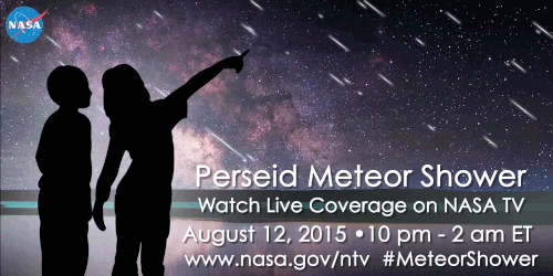
What are Perseid Meteors, and why should you be excited for them this year? Let us tell you!
The Perseid meteor shower is caused by debris from Comet Swift-Tuttle as it swings through the inner solar system and ejects a trail of dust and gravel along its orbit. When the Earth passes through the debris, specs of comet-stuff hit the atmosphere at 140,000 mph and disintegrate in flashes of light. Meteors from this comet are called Perseids because they seem to fly out of the constellation Perseus.

Last year, this meteor shower peaked during a bright “supermoon”, so visibility was reduced. Luckily, forecasters say the show could be especially awesome this year because the Moon is nearly new when the shower peaks on Aug. 12-13.
The best place to view the event is away from city lights around midnight. Under a clear, dark sky forecasters predict meteor rates as high as 100 per hour on peak night. So, get outside, look up and enjoy the show!
If your area has poor visibility on the peak night, we’ve got you covered! We’ll be hosting a live broadcast about the meteor shower from 10 p.m. EDT Wednesday, Aug. 12, to 2 a.m. Thursday, Aug. 13. In addition to footage from our live skycam, the program will highlight the science behind the Perseids, as well as our research related to meteors and comets. Tune in on NASA TV or our UStream Channel.
What was your reaction to getting selected for the Air Force Fellows program?
A Total Solar Eclipse Revealed Solar Storms 100 Years Before Satellites
Just days from now, on Aug. 21, 2017, the Moon will pass between the Sun and Earth, casting its shadow down on Earth and giving all of North America the chance to see a solar eclipse. Remember that it is never safe to look at the partially eclipsed or uneclipsed Sun, so make sure you use a solar filter or indirect viewing method if you plan to watch the eclipse.

Eclipses set the stage for historic science. Past eclipses enabled scientists to study the Sun’s structure, find the first proof of Einstein’s theory of general relativity, and discover the element helium — 30 years before it was found on Earth..
We’re taking advantage of the Aug. 21 eclipse by funding 11 ground-based scientific studies. As our scientists prepare their experiments for next week, we’re looking back to an historic 1860 total solar eclipse, which many think gave humanity our first glimpse of solar storms — called coronal mass ejections — 100 years before scientists first understood what they were.

Coronal mass ejections, or CMEs, are massive eruptions made up of hot gas, plasma and magnetic fields. Bursting from the Sun’s surface, these giant clouds of solar material speed into space up to a million miles per hour and carry enough energy to power the world for 10,000 years if we could harness it. Sometimes, when they’re directed towards Earth, CMEs can affect Earth’s space environment, creating space weather: including triggering auroras, affecting satellites, and – in extreme cases – even straining power grids.

Scientists observed these eruptions in the 1970s during the beginning of the modern satellite era, when satellites in space were able to capture thousands of images of solar activity that had never been seen before.

But in hindsight, scientists realized their satellite images might not be the first record of these solar storms. Hand-drawn records of an 1860 total solar eclipse bore surprising resemblance to these groundbreaking satellite images.
On July 18, 1860, the Moon’s shadow swept across North America, Spain and North Africa. Because it passed over so much populated land, this eclipse was particularly well-observed, resulting in a wealth of scientific observations.

Drawings from across the path of the 1860 eclipse show large, white finger-like projections in the Sun’s atmosphere—called the corona—as well as a distinctive, bubble-shaped structure. But the observations weren’t uniform – only about two-thirds of the 1860 eclipse sketches showed this bubble, setting off heated debate about what this feature could have been.

Sketches from the total solar eclipse of July 1860.
One hundred years later, with the onset of space-based satellite imagery, scientists got another piece of the puzzle. Those illustrations from the 1860 eclipse looked very similar to satellite imagery showing CMEs – meaning 1860 may have been humanity’s first glimpse at these solar storms, even though we didn’t understand what we were seeing.

While satellites provide most of the data for CME research, total solar eclipses seen from the ground still play an important role in understanding our star. During an eclipse, observers on the ground are treated to unique views of the innermost corona, the region of the solar atmosphere that triggers CMEs.
This region of the Sun’s atmosphere can’t be measured at any other time, since human-made instruments that create artificial eclipses must block out much of the Sun’s atmosphere—as well as its bright face—in order to produce clear images. Yet scientists think this important region is responsible for accelerating CMEs, as well as heating the entire corona to extraordinarily high temperatures.

When the path of an eclipse falls on land, scientists take advantage of these rare chances to collect unique data. With each new total solar eclipse, there’s the possibility of new information and research—and maybe, the chance to reveal something as astronomical as the first solar storm.

Learn all about the Aug. 21 eclipse at eclipse2017.nasa.gov, and follow @NASASun on Twitter and NASA Sun Science on Facebook for more. Watch the eclipse through the eyes of NASA at nasa.gov/eclipselive starting at 12 PM ET on Aug. 21.
Make sure to follow us on Tumblr for your regular dose of space: http://nasa.tumblr.com
Amazing Earth: Satellite Images from 2020
In the vastness of the universe, the life-bringing beauty of our home planet shines bright. During this tumultuous year, our satellites captured some pockets of peace, while documenting data and striking visuals of unprecedented natural disasters. As 2020 comes to a close, we’re diving into some of the devastation, wonders, and anomalies this year had to offer.
NASA’s fleet of Earth-observing satellites and instruments on the International Space Station unravel the complexities of the blue marble from a cosmic vantage point. These robotic scientists orbit our globe constantly, monitoring and notating changes, providing crucial information to researchers here on the ground.
Take a glance at 2020 through the lens of NASA satellites:
A Delta Oasis in Southeastern Kazakhstan

Seen from space, the icy Ili River Delta contrasts sharply with the beige expansive deserts of southeastern Kazakhstan.
When the Operational Land Imager (OLI) on Landsat 8 acquired this natural-color image on March 7, 2020, the delta was just starting to shake off the chill of winter. While many of the delta’s lakes and ponds were still frozen, the ice on Lake Balkhash was breaking up, revealing swirls of sediment and the shallow, sandy bed of the western part of the lake.
The expansive delta and estuary is an oasis for life year round. Hundreds of plant and animal species call it home, including dozens that are threatened or endangered.
Fires and Smoke Engulf Southeastern Australia

A record-setting and deadly fire season marred the beginning of the year in Australia. Residents of the southeastern part of the country told news media about daytime seeming to turn to night, as thick smoke filled the skies and intense fires drove people from their homes.
This natural-color image of Southeastern Australia was acquired on January 4, 2020, by the Moderate Resolution Imaging Spectroradiometer (MODIS) on NASA’s Aqua satellite. The smoke has a tan color, while clouds are bright white. It is likely that some of the white patches above the smoke are pyrocumulonimbus clouds—clouds created by the convection and heat rising from a fire.
Nighttime Images Capture Change in China

A team of scientists from NASA’s Goddard Space Flight Center (GSFC) and Universities Space Research Association (USRA) detected signs of the shutdown of business and transportation around Hubei province in central China. As reported by the U.S. State Department, Chinese authorities suspended air, road, and rail travel in the area and placed restrictions on other activities in late January 2020 in response to the COVID-19 outbreak in the region.
A research team analyzed images of Earth at night to decipher patterns of energy use, transportation, migration, and other economic and social activities. Data for the images were acquired with the Visible Infrared Imaging Radiometer Suite (VIIRS) on the NOAA–NASA Suomi NPP satellite (launched in 2011) and processed by GSFC and USRA scientists. VIIRS has a low-light sensor—the day/night band—that measures light emissions and reflections. This capability has made it possible to distinguish the intensity, types, and sources of lights and to observe how they change.
The Parched Paraná River

Though a seemingly serene oasis from above, there is more to this scene than meets the eye. On July 3, 2020, the Operational Land Imager (OLI) on Landsat 8 captured this false-color image of the river near Rosario, a key port city in Argentina. The combination of shortwave infrared and visible light makes it easier to distinguish between land and water. A prolonged period of unusually warm weather and drought in southern Brazil, Paraguay, and northern Argentina dropped the Paraná River to its lowest water levels in decades. The parched river basin has hampered shipping and contributed to an increase in fire activity in the delta and floodplain.
The drought has affected the region since early 2020, and low water levels have grounded several ships, and many vessels have had to reduce their cargo in order to navigate the river. With Rosario serving as the distribution hub for much of Argentina’s soy and other farm exports, low water levels have caused hundreds of millions of dollars in losses for the grain sector, according to news reports.
Historic Fires Devastate the U.S. Pacific Coast

Climate and fire scientists have long anticipated that fires in the U.S. West would grow larger, more intense, and more dangerous. But even the most experienced among them have been at a loss for words in describing the scope and intensity of the fires burning in West Coast states during September 2020.
Lightning initially triggered many of the fires, but it was unusual and extreme meteorological conditions that turned some of them into the worst conflagrations in the region in decades.
Throughout the outbreak, sensors like the Visible Infrared Imaging Radiometer Suite (VIIRS) and the Ozone Mapping and Profiler Suite (OMPS) on the NOAA-NASA Suomi NPP satellite collected daily images showing expansive, thick plumes of aerosol particles blowing throughout the U.S. West on a scale that satellites and scientists rarely see.
This image shows North America on September 9th, 2020, as a frontal boundary moved into the Great Basin and produced very high downslope winds along the mountains of Washington, Oregon, and California. The winds whipped up the fires, while a pyrocumulus cloud from the Bear fire in California injected smoke high into the atmosphere. The sum of these events was an extremely thick blanket of smoke along the West Coast.
The Sandy Great Bahama Bank

Though the bright blues of island waters are appreciated by many from a sea-level view, their true beauty is revealed when photographed from space. The underwater masterpiece photographed above is composed of sand dunes off the coast of the Bahamas.
The Great Bahama Bank was dry land during past ice ages, but it slowly submerged as sea levels rose. Today, the bank is covered by water, though it can be as shallow as two meters (seven feet) deep in places. The wave-shaped ripples in the image are sand on the seafloor. The curves follow the slopes of the dunes, which were likely shaped by a fairly strong current near the sea bottom. Sand and seagrass are present in different quantities and depths, giving the image it’s striking range of blues and greens.
This image was captured on February 15th, 2020, by Landsat 8, whose predecessor, Landsat 7, was the first land-use satellite to take images over coastal waters and the open ocean. Today, many satellites and research programs map and monitor coral reef systems, and marine scientists have a consistent way to observe where the reefs are and how they are faring.
Painting Pennsylvania Hills

Along with the plentiful harvest of crops in North America, one of the gifts of Autumn is the gorgeous palette of colors created by the chemical transition and fall of leaves from deciduous trees.
The folded mountains of central Pennsylvania were past peak leaf-peeping season but still colorful when the Operational Land Imager (OLI) on the Landsat 8 satellite passed over on November 9, 2020. The natural-color image above shows the hilly region around State College, Pennsylvania overlaid on a digital elevation model to highlight the topography of the area.
The region of rolling hills and valleys is part of a geologic formation known as the Valley and Ridge Province that stretches from New York to Alabama. These prominent folds of rock were mostly raised up during several plate tectonic collisions and mountain-building episodes in the Ordovician Period and later in the creation of Pangea—when what is now North America was connected with Africa in a supercontinent. Those events created the long chain of the Appalachians, one of the oldest mountain ranges in the world.
A Dangerous Storm in the Night

Ominous and looming, a powerful storm hovered off the US coastline illuminated against the dark night hues.
The Visible Infrared Imaging Radiometer Suite (VIIRS) on NOAA-20 acquired this image of Hurricane Laura at 2:20 a.m. Central Daylight Time on August 26, 2020. Clouds are shown in infrared using brightness temperature data, which is useful for distinguishing cooler cloud structures from the warmer surface below. That data is overlaid on composite imagery of city lights from NASA’s Black Marble dataset.
Hurricane Laura was among the ten strongest hurricanes to ever make landfall in the United States. Forecasters had warned of a potentially devastating storm surge up to 20 feet along the coast, and the channel might have funneled that water far inland. It did not. The outcome was also a testament to strong forecasting and communication by the National Hurricane Center and local emergency management authorities in preparing the public for the hazards.
A Windbreak Grid in Hokkaido

From above, the Konsen Plateau in eastern Hokkaido offers a remarkable sight: a massive grid that spreads across the rural landscape like a checkerboard, visible even under a blanket of snow. Photographed by the Operational Land Imager (OLI) on Landsat 8, this man-made design is not only aesthetically pleasing, it’s also an agricultural insulator.
The strips are forested windbreaks—180-meter (590-foot) wide rows of coniferous trees that help shelter grasslands and animals from Hokkaido’s sometimes harsh weather. In addition to blocking winds and blowing snow during frigid, foggy winters, they help prevent winds from scattering soil and manure during the warmer months in this major dairy farming region of Japan.
Shadows from a Solar Eclipse

Formidable, rare, and awe-inspiring — the first and only total solar eclipse of 2020 occurred on December 14, with the path of totality stretching from the equatorial Pacific to the South Atlantic and passing through southern Argentina and Chile as shown in the lower half of the image above. The Advanced Baseline Imager (ABI) on Geostationary Operational Environmental Satellite 16 (GOES-16) captured these images of the Moon’s shadow crossing the face of Earth.
The “path of totality” (umbral path) for the eclipse was roughly 90 kilometers (60 miles) wide and passed across South America from Saavedra, Chile, to Salina del Eje, Argentina. While a total eclipse of the Sun occurs roughly every 18 months, seeing one from any particular location on Earth is rare. On average, a solar eclipse passes over the same parcel of land roughly every 375 years. The next total solar eclipse will occur on December 4, 2021 over Antarctica, and its next appearance over North America is projected for April 8, 2024.
For additional information and a look at more images like these visit NASA’s Earth Observatory.
Make sure to follow us on Tumblr for your regular dose of space: http://nasa.tumblr.com.
How Well Do You Know Mercury?
Mercury is the smallest planet in our solar system and is only slightly larger than Earth’s moon. To give you some perspective, if the sun were as tall as a typical front door, Earth would be the size of a nickel and Mercury would be about as big as a green pea.

Mercury is the closest planet to the sun. Daytime temperatures can reach 430 degrees Celsius (800 degrees Fahrenheit) and drop to –180 degrees Celsius (-290 degrees Fahrenheit) at night.
Here are a few fun facts about Mercury:
Mercury takes only 88 Earth days to orbit the sun
If we could stand on Mercury’s surface when it is at its closest point to the sun, the sun would appear more than three times larger than it does here on Earth
Mercury is home to one of the largest impact basins in the solar system: the Caloris Basin. The diameter of this impact basin is the length of 16,404 football fields (minus the end zones) placed end to end!
Mercury is one of only two planets in our solar system that do not have moons (Venus is the other one)
Mercury completes three rotations for every two orbits around the sun. That means that if you wanted to stay up from sunrise to sunrise on Mercury, you’d be up for 176 Earth days…you’d need a LOT of coffee!

Two missions have visited Mercury:
Mariner 10 was the first mission to Mercury, and 30 years later, our MESSENGER mission was the second to visit the planet. Mariner 10 was also the first spacecraft to reach one planet by using the gravity of another planet (in this case, Venus) to alter its speed and trajectory.

MESSENGER was the first spacecraft to orbit Mercury, The spacecraft had its own shades to protect it from the light of the sun. This is important since sunlight on Mercury can be as much as 11 times brighter than it is here on Earth. The spacecraft was originally planned to orbit Mercury for one year, but exceeded expectations and worked for over four years capturing extensive data. On April 30, 2015, the spacecraft succumbed to the pull of solar gravity and impacted Mercury’s surface.
Water Ice?
The MESSENGER spacecraft observed compelling support for the long-held hypothesis that Mercury harbors abundant water ice and other frozen volatile materials in its permanently shadowed polar craters.

This radar image of Mercury’s north polar region. The areas shown in red were captured by MESSENGER, compared to the yellow deposits imaged by Earth-based radar. These areas are believed to consist of water ice.
Mercury Transit of the Sun
For more than seven hours on Monday, May 9, Mercury will be visible as a tiny black dot crossing the face of the sun. This rare event – which happens only slightly more than once a decade – is called a transit.

Where: Skywatchers in Western Europe, South America and eastern North America will be able to see the entirety of the transit. The entire 7.5-hour path across the sun will be visible across the Eastern U.S. – with magnification and proper solar filters – while those in the West can observe the transit in progress at sunrise.

Watch: We will stream a live program on NASA TV and the agency’s Facebook page from 10:30 to 11:30 a.m. – an informal roundtable during which experts representing planetary, heliophysics and astrophysics will discuss the science behind the Mercury transit. Viewers can ask questions via Facebook and Twitter using #AskNASA. Unlike the 2012 Venus transit of the sun, Mercury is too small to be visible without magnification from a telescope or high-powered binoculars. Both must have safe solar filters made of specially-coated glass or Mylar; you can never look directly at the sun.
To learn more about our solar system and the planets, visit: http://solarsystem.nasa.gov/
Make sure to follow us on Tumblr for your regular dose of space: http://nasa.tumblr.com
-
 fractiplosis liked this · 1 year ago
 -
 alllthequeenshorses reblogged this · 1 year ago
 -
 samfparker reblogged this · 1 year ago
 -
 tenigam reblogged this · 1 year ago
 -
tenigam liked this · 1 year ago
-
 lighthouse-in-a-storm liked this · 1 year ago
 -
 jiffisquid liked this · 1 year ago
 -
 profanities-of-common-sense reblogged this · 1 year ago
 -
 navalhistory reblogged this · 1 year ago
 -
 gaziliatron9000 liked this · 3 years ago
 -
 shiny-aesthetic liked this · 3 years ago
 -
 tom-tomorrow reblogged this · 3 years ago
 -
 kewpiedoll liked this · 3 years ago
 -
 loralegel liked this · 3 years ago
 -
 venus-u reblogged this · 3 years ago
 -
venus-u liked this · 3 years ago
-
 gdel82 liked this · 3 years ago
 -
 profgrewbeard reblogged this · 3 years ago
Explore the universe and discover our home planet with the official NASA Tumblr account
1K posts